Good Morning. This is Dave Zinn with a spring weather and snowpack update on Friday, April 17th. The Gallatin National Forest Avalanche Center has stopped issuing daily avalanche forecasts for the season. We will issue weather and snowpack updates on Monday and Friday mornings through April.
This week’s storm totaled 8-12” in the Bridger, Madison, and Gallatin Ranges and 2-3” in the mountains around West Yellowstone and Cooke City. Winds ranged 5-15 mph with gusts of 30 mph from the northwest before shifting to the east and now back to the west. High temperatures in the mountains were in the 20s F and near 30 F in the Bridger Range.
The weekend will start off with sunny skies and warm temperatures before clouds build late Saturday afternoon with 1-2” of snow possible by Sunday. High temperatures will be in the upper 30s to 40s F with moderate winds 15-25 mph from the west to southwest until late Saturday when they will calm to 5-15 mph for the remainder of the weekend.

All Regions
This week a spring storm delivered 8-12” of snow (0.6 - 0.8” of snow water equivalent – SWE) to the mountains except near Cooke City and West Yellowstone which received 2-3” (0.3” SWE). During and following the storm skiers and riders triggered avalanches within the new snow, many ran fast and far. Look back through our avalanche activity list to see a summary of these events. Warm temperatures and sunny skies today and intermittently through the weekend will rapidly increase the wet snow avalanche danger. When the snow under your feet starts getting wet or you see roller balls and pinwheels, stay off steep slopes, move to cooler aspects, or call it a day.
Avalanches breaking within the new snow and on weak layers buried 1-3’ deep are also possible this weekend. Wind will increase to 15-25 mph through the early part of the weekend creating new drifts of snow where skiers and riders could initiate a slide. If you see recent avalanche activity or cracks shooting out from your sled, board, or skis you found an area with unstable snow. Move on and find low angle terrain. Perform a quick extended column test to look for these instabilities if they don’t jump out at you. The storm moving into the area Saturday night does not look like it will bring significant snowfall. However, if the storm exceeds expectations, the avalanche danger will rise with new snow.
On Wednesday, there was an avalanche fatality in Colorado (preliminary report). This was the third fatality in April (avalanche accident database). Be safe if you go into the mountains this weekend.
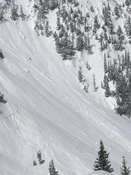
Note if you are touring at Bridger Bowl: Familiarity with the terrain from when the ski area is open influences our decision-making. Ski patrol has not done avalanche mitigation work in over a month and our “normal” routes may not be advisable. For example, the North Bowl Road crosses through the middle of serious avalanche terrain that is managed during the season. It is not a good route for your skin track as some skiers learned this week (photo).
See our forecast page and this article for general spring snowpack and travel advice.
Please continue to send us your observations. You can fill out an observation form, email us (mtavalanche@gmail.com), leave a VM at 406-587-6984, or Instagram (#gnfacobs). We greatly appreciate your support.
Give Big Gallatin Valley
Give Big Gallatin Valley is April 30th - May 1st. The Friends of the Avalanche Center are participating again this year and want to thank all of you for your support.
CLOSURES AND STAY-AT-HOME ORDER
A Stay at Home order is in effect for the State of Montana due to COVID-19. This order specifically discourages “outdoor recreation activities that pose enhanced risks of injury or could otherwise stress the ability of local first responders to address the COVID-19 emergency (e.g., backcountry skiing in a manner inconsistent with avalanche recommendations or in closed terrain)”.
Bridger Bowl is closed and advises against uphill travel which could place first responders at risk. Backcountry conditions exist. There is no avalanche control or ski patrol rescue. Please do not loiter or congregate in the parking lots.
Park County is requesting anyone who is not a permanent resident or provider of essential service to avoid travel to Cooke City/ Silvergate. This includes both single day and overnight visitors.
Hyalite Canyon is closed to vehicle traffic and will reopen on May 16th. This is the regular spring use closure.
GENERAL SPRING SNOWPACK AND TRAVEL ADVICE
Spring weather can be highly variable and create a mix of avalanche problems to watch out for. Snow conditions and stability can change drastically from day to day or hour to hour. Anticipate rapid change and plan accordingly. Abundant snowfall over the winter with more spring snow to come makes avalanches possible into summer.
NEW SNOW AND WIND LOADED SLOPES
Spring storms are notorious for depositing heavy amounts of snow in the mountains. Even with a deep and generally stable snowpack throughout the advisory area, heavy and rapid loads of new snow will decrease stability. The main problems to look out for are avalanches breaking within the new snow, wind slabs, and loose snow avalanches. The likelihood of triggering an avalanche spikes during and immediately after snowstorms. New snow instabilities tend to stabilize quickly, but it’s a good idea to give new snow a day to adjust before hitting big terrain. New snow instabilities can be difficult to assess, and spring storms bond to old snow differently across aspects and elevations. Conservative terrain selection is essential during and immediately following storms. Wind loaded slopes and slopes steeper than 35 degrees should be avoided for 24-48 hours after new snow and wind.
New snow can quickly change from dry to wet on a spring day, and stability can decrease rapidly with above freezing temperatures or brief sunshine. New snow may bond well early in the morning, and then easily slide later. Wet loose slides are likely during the first above freezing temperatures or sunshine immediately after a storm. Anticipate changes in snow stability as you change aspect or elevation, and over the course of the day. An early start is always an advantage. Be ready to change plans or move to safer terrain at the first signs of decreasing stability.
WET SNOW AVALANCHES
Spring and wet snow avalanches go hand-in-hand. Above freezing temperatures, rain, and/or intense sunshine cause the snow to become wet and weak, and make wet avalanches easy to trigger or release naturally. Conditions tend to become most unstable when temperatures stay above freezing for multiple days and nights in a row. Avoid steep terrain, and be aware of potential for natural wet avalanches in steep terrain above you, if you see:
· Heavy rain,
· Above freezing temperatures for more than 24 hours,
· Natural wet avalanches,
· Roller balls or pin wheels indicating a moist or wet snow surface,
· Or if you sink to your boot top in wet snow.
In general, if the snow surface freezes solid overnight, the snowpack will be stable in the morning and stability will decrease through the day as snow warms up. The snow surface hardness, rate of warming, duration of sunshine, aspect and elevation determine how fast stability will decrease through the day. Be aware that sunny aspects may have a wet snow avalanche danger while shadier slopes still have a dry snow avalanche danger. Getting off of steep slopes should be considered when, or before, the above signs of instability are present. Wet snow avalanches, whether loose snow or slabs, can be powerful, destructive and very dangerous. Conservative terrain choices, starting early in the day, and careful observations can keep you safe. See Alex’s recent video, and this article for more spring travel advice.
CORNICES
Cornices along ridgelines are massive and can break under the weight of a person (photo). Prolonged above freezing temperatures and rain make them weaker and possible to break naturally. They can break off suddenly and farther back than one might expect. Cornice falls can also entrain large amounts of loose snow or trigger slab avalanches. Stay far back from the edge of ridgelines and minimize exposure to slopes directly below cornices. Regardless of whether a cornice triggers a slide or not, a falling cornice is dangerous to anyone in its path.
DISCLAIMER
It does not matter if new snow falls or not, avalanches will continue to occur until the existing snowpack is mostly gone. Always assess the slope you plan to ride with diligence and safety in mind. Do not let your guard down. Travel with a partner, carry rescue gear and only expose one person at a time in avalanche terrain.
Have a safe and enjoyable spring and summer!
Doug, Alex, Ian and Dave
For more spring travel advice see this article from our GNFAC forecaster blog.
On Wednesday in Colorado, a backcountry tourer was caught and killed by an avalanche after getting carried 1800’ and sustaining fatal injuries. This is the third fatality in April. Our deepest sympathy goes out to the victim’s family and friends. You can read the preliminary report or the article from the Colorado Sun to learn more.