Good Morning. This is Alex Marienthal with the Gallatin National Forest Avalanche Forecast on Sunday, December 13th at 7:00 a.m. This forecast is sponsored by Cooke City Super 8/Bearclaw Bob’s and Stronghold Fabrication. This forecast does not apply to operating ski areas.
*Note: Bridger Bowl Ski Area is closed and there is no avalanche control or ski patrol services. Backcountry conditions exist. Workers are setting up for the season and making snow. Please stay clear of work areas, snow guns, chairlifts and other equipment.
Since yesterday morning the mountains got 1-3” of low-density snow. Wind has been west-southwest at 5-15 mph with gusts to 25 mph. This morning temperatures are single digits to low teens F. Today temperatures will reach high teens to low 20s F with west-southwest wind at 15-25 mph. Snow tonight will drop 2-3” by morning with another 3-5” during the day tomorrow.

Today, moderate wind out of the west-southwest will drift the new low-density snow into thicker slabs, and a weak underlying snowpack can’t be trusted to hold much. Yesterday I was on the Bridger ridge, there was minimal wind, and I had a small 4” deep drift crack 20 feet wide under my skis (photo). Watch for blowing snow as a sign these fresh wind slabs are forming.
The mountains near Bozeman, Big Sky and West Yellowstone have 1-2 feet of sugary, faceted snow on the ground which will struggle to support the weight of additional snow. See our videos from the last couple weeks in the field for a good look at this weak snowpack (Lionhead video, Beehive video, Saddle Peak video, Buck Ridge video). The snow that fell since Friday morning totaled 3-6”, and was very low density equaling 0.1-0.3” of snow water equivalent (SWE). This is not enough weight to create widespread instability, but starts a trend of decreasing stability through this week.
Small dry loose avalanches are possible to trigger on steeper avalanche slopes (>36 degrees). A couple were reported within the new snow yesterday near Big Sky, Bridger and Cooke City. These can entrain the weak faceted snowpack below and become large enough to push a person down a slope, into trees, rocks or cliffs (photo).
Today the avalanche danger is MODERATE on wind-loaded slopes, and LOW on other slopes.

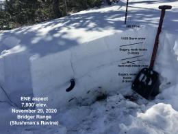
The mountains near Cooke City have 2-4 feet of snow on the ground, and a generally stronger snowpack than the rest of the advisory area. Ian and I were there nine days ago and found some pockets of weak, sugary snow lower in the snowpack (video). There have also been a few reports of buried surface hoar, so it is worthwhile to dig and perform stability tests to search for these layers.
The snowpack near Cooke City will handle the couple inches of low-density new snow that fell yesterday, and avalanches are unlikely today. We can’t completely rule out small wind slabs that will form with moderate wind today, and dry loose avalanches in steeper avalanche terrain. If you plan to travel on steep slopes, carefully assess the snowpack and consequences of a slide. Today the avalanche danger is LOW.
If you get out, please send us your observations no matter how brief. You can submit them via our website, email (mtavalanche@gmail.com), phone (406-587-6984), or Instagram (#gnfacobs).
Upcoming Avalanche Education and Events
See our education calendar for an up to date list of all local classes. Here are a few select upcoming events and opportunities to check out:
Every Saturday in Cooke City, FREE snowpack update and rescue practice at the Round Lake Warming Hut between 10 a.m. and 3 p.m. Starts this Saturday, November 28. Poster with More Info.
Wednesday, December 16, 6-7 p.m., FREE online 1-hr Avalanche Awareness sponsored by Uphill Pursuits.
Monday, December 21, 6-7 p.m., FREE online 1-hr Avalanche Awareness sponsored by Mystery Ranch. Join HERE.
January 20 & 21 (plus field sessions the following weekends), Avalanche Fundamentals with Field Course. There are separate field sessions tailored for both skiers and splitboarders (Bridger Bowl) and snowmobilers (Buck Ridge). Register here.
Doug worked with Bruce Jamieson on a video about when, where and how to perform stability tests. Watch it here.