Good Morning. This is Doug Chabot with the Gallatin National Forest Avalanche Forecast on Thursday, December 17th at 7:30 a.m. This forecast is sponsored by Werner Wealth Management (Advisors with DA Davidson) and Montana Backcountry Alliance. This forecast does not apply to ski areas.
In the last 24 hours 3-4” of snow fell in the southern ranges and Cooke City, and 1” of snow in the mountains around Big Sky and Bozeman. Winds are strong and gusty from the W-SW with speeds averaging 20-35 mph and gusting to 65 mph up Hyalite. Winds will continue to be strong and temperatures will reach the high 20s. Scattered snowfall today will end late this afternoon. By morning the southern mountains and Cooke City will get 3” with the 1-2” in the northern ranges.

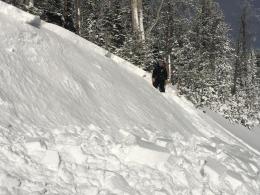
The 2-3 foot deep snowpack in the mountains south of Big Sky to West Yellowstone consists of mostly weak, faceted, sugary snow. Every day over the last 6 days snow has fallen and the winds have blown (wx log). This incremental loading is creating instability. I was in the Lionhead area over the last 2 days and found very weak snow (video). Yesterday, I was able to avalanche a small sidehill that was wind-loaded (photo), another skier saw a small avalanche on the Fawn Pass/Bighorn loop in YNP (details), and a sledder got the weak layer to propagate/fracture in his stability tests on the heavily wind-loaded Two Top Mountain (video). These red flags are evidence of a rising instability, especially on wind-loaded slopes. Avalanches, shooting cracks and whumpfs are signs to recreate elsewhere.
The avalanche danger is rated CONSIDERABLE on wind-loaded slopes and MODERATE on all others.

The northern ranges received 1” of snow and strong west to southwest wind. The snowpack is mostly thin (2 feet or less) and weak. Sugary, faceted snow is the overwhelming theme. Wind-loaded slopes at ridgetops or gullies are where increased avalanche danger lurks. Dave and Ian show us this recipe in Tuesday’s video north of Bridger Bowl. We are finding the same snowpack structure and recipe for avalanches throughout the Bridger, northern Gallatin and northern Madison Ranges (video playlist).
Snow storms have been small with only a few inches falling at a time. This incremental loading is slowly building a slab which is becoming unstable on wind-loaded slopes. Both Big Sky and Bridger Ski Areas have a snowpack similar to the backcountry and they are getting avalanches with explosives. Additionally, skiers in Beehive Basin are getting unstable test scores, a first of the season and a telling sign of future problems. Be careful traveling onto wind-loaded slopes and retreat if you get cracks shooting out from your skis or sled, or feel a whumpf. Today the avalanche danger is rated MODERATE on wind-loaded slopes and LOW on all other slopes.
Cooke City got 4” of snow (.3” snow water equivalent) and moderate southwest wind. The snowpack here lacks widespread weak layers and is 4-5 feet deep, but current wind-loading will create drifts which could be triggered. A foot of snow that fell in the last 7 days is being blown around. Drifts could be a couple feet thick and should be avoided. Shooting cracks are signs of instability and a warning to go play on a non-wind-loaded slope. For today, the avalanche danger is rated MODERATE on wind-loaded slopes and LOW on all other slopes.
If you get out, please send us your observations no matter how brief. You can submit them via our website, email (mtavalanche@gmail.com), phone (406-587-6984), or Instagram (#gnfacobs).
Upcoming Avalanche Education and Events
See our education calendar for an up to date list of all local classes. Here are a few select upcoming events and opportunities to check out:
Every Saturday in Cooke City, FREE snowpack update and rescue practice at the Round Lake Warming Hut between 10 a.m. and 3 p.m. Starts this Saturday, November 28. Poster with More Info.
Monday, December 21, 6-7 p.m., FREE online 1-hr Avalanche Awareness sponsored by Mystery Ranch. Join HERE.
January 20 & 21 (plus field sessions the following weekends), Avalanche Fundamentals with Field Course. There are separate field sessions tailored for both skiers and splitboarders (Bridger Bowl) and snowmobilers (Buck Ridge). Register here.
Doug worked with Bruce Jamieson on a video about when, where and how to perform stability tests. Watch it here.