Good Morning. This is Doug Chabot with the Gallatin National Forest Avalanche Forecast on St. Patrick’s Day, Wednesday, March 17th at 7:00 a.m. Today’s forecast is sponsored by Spark R&D and Highline Partners. This forecast does not apply to operating ski areas.
Under clear skies mountain temperatures are in the high teens to low 20s F this morning. Wind is light at 1-10 mph out of the southeast. Today will be sunny with mountain temperatures hitting the high 40s F, our warmest day yet. Temperatures will drop into the 20s tonight with an even warmer day tomorrow.

WET AVALANCHE DANGER
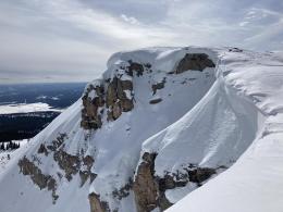
The sun’s power is intense. Low elevation slopes that get sunshine are melting, getting slushy and becoming quickly unstable. Today's clear skies and unseasonably warm temperatures will also impact high elevation slopes that are sunny. If you are sinking past your ankles in wet snow you are susceptible to triggering or getting caught in a wet avalanche (loose slides at high elevations and wet slabs at lower) and heading out of the backcountry is recommended. You can seek shady, cooler aspects (ie. high, northern facing slopes), but unless you parked your vehicle there, you'll have to navigate wet terrain on your exit. Ian was in Lionhead yesterday and saw first-hand how aspect, elevation and timing affects wet avalanche danger (video). Today I expect many loose wet avalanches as well as cornices sagging and potentially breaking (picture from Lionhead, Abiathar cornice fall). The wet snow avalanche danger will start LOW but rise to CONSIDERABLE on all sunny slopes.
On slopes that remain dry the snowpack will be generally stable. There is still weak snow (depth hoar) near the ground and a person would have to be extremely unlucky to trigger an avalanche on this layer. For today the dry snow avalanche danger is rated LOW on all slopes.

Yesterday I toured up Sheep Creek north of Cooke City and found a frozen surface on one side of the valley (SW facing) and dry snow on the opposite (NE). I dug on a northeast aspect at 9,000 feet and did not find any weakness, nor did I see any signs of instability (video). There might be a rogue wind slab lurking about, but in general it is unlikely someone could trigger an avalanche. These mountains will reach the low 40s F this afternoon and triggering wet avalanches is a possibility, mostly on sunny, lower elevation slopes. For today, the dry snow avalanche danger is rated LOW. The wet snow avalanche danger will start LOW but rise to MODERATE on slopes getting sun. Seeing roller balls, pinwheels or sinking past your ankles in wet snow are signs to head home.
Upcoming Avalanche Education and Events
See our education calendar for an up-to-date list of all local classes. Here are a few select upcoming events and opportunities to check out:
March 20, 5:30 p.m., Snowpack Update for Bozeman Splitfest, online Link to Join HERE
March 24, 6 p.m., Free 1-Hour Avalanche Awareness, online Link to Join HERE
March 29, 6 p.m., Free 1-Hour Avalanche Awareness, online Link to Join HERE
The University of Nevada, Reno School of Medicine and Montana State University are doing a brief survey to learn if and how the use of the winter backcountry has changed due to the coronavirus pandemic. The 5-minute survey is HERE.