Good Morning. This is Dave Zinn with the Gallatin National Forest Avalanche Forecast on Tuesday, April 6th at 7:15 a.m. Today’s forecast is sponsored by the Yellowstone Club Community Foundation. This forecast does not apply to operating ski areas.
Bridger Bowl is closed and backcountry conditions exist. There is no avalanche mitigation or ski patrol rescue. Please stay clear of work areas, snowmobiles, chair lifts and other equipment.
Temperatures this morning are in the 20s F with 5-10 mph winds from the north. The Gallatin Range, Southern Madison Range and Lionhead Area received 5-8” of snow with 3-4” in the Bridger Range, Northern Madison Range and the mountains around Cooke City. Today, temperatures will rise to the mid to upper-30s F with 5-10 mph winds from the north. Morning snowfall will deliver 2-4” to the ranges south of Big Sky and near Cooke City and 1-2” to the northern ranges.

All Regions
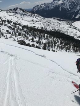
The mountains received 3-6” of snow equal to 0.3-0.7” of snow water equivalent-SWE with 8” (0.8” SWE) in the Taylor Fork. Continued snowfall this morning will add a couple more inches to the storm total. The old snow surface and the amount of new snow will define avalanches today (video). In many areas, a crust formed by cooler temperatures will limit the depth of avalanches the height of the new snow. Assess the interface between the old and new snow before going onto steep slopes remembering that it does not take a very deep avalanche to tumble a skier or rider through nasty terrain. Expect conditions to change and avalanches to become more likely as temperatures warm in the afternoon and the sun hits slopes for the first time.
Where the old snow surface didn’t freeze or precipitation began as rain, avalanches may gouge deeper and be more destructive (wet slab video). Avoid steep terrain where your skis or sled drop into unsupportable wet snow below the storm snow.
Human-triggered avalanches are possible today and the danger is rated MODERATE.
If you get out, please send us your observations no matter how brief. You can submit them via our website, email (mtavalanche@gmail.com), phone (406-587-6984), or Instagram (#gnfacobs).
Upcoming Avalanche Education and Events
See our education calendar for an up-to-date list of all local classes.
We will end regular forecasts next weekend, but avalanches will still be possible through April or longer. Remain vigilant with safe travel practices and snowpack assessments throughout the duration of your ski season.