Good morning. This is Alex Marienthal with the Gallatin National Forest Avalanche Forecast on Monday, January 3rd at 7:00 a.m. This information is sponsored by Highline Partners and Gallatin County Sheriff Search and Rescue. This forecast does not apply to operating ski areas.
Since yesterday evening wind has been 15-30 mph out of the south-southwest with gusts of 45-55mph. This morning temperatures are single digits to low teens F. No snow has fallen in the last 24 hours. Today will be mostly cloudy with temperatures in the teens to mid-20s F and southwest wind at 15-30 mph with gusts of 35-55 mph. Snow is expected tonight and tomorrow with 2-4” possible by tomorrow morning.

A person can trigger avalanches 1-5 feet deep, within or below snow that fell over the past couple weeks. Strong southwest wind will drift snow into fresh slabs that could avalanche under the weight of a person. These drifts could be large enough to bury someone and could trigger an avalanche deeper and wider on buried weak layers (Lionhead video). The last three days without new snow mean it is becoming more difficult to trigger large avalanches breaking below the recent snow, but it is still possible. Yesterday riders near Cooke City reported an avalanche on Mt. Abundance which is a few days old, but it shows what is possible and an example of type of terrain to stay away from today (photo, photo). Today, human triggered avalanches are possible and the avalanche danger is MODERATE.
In the Bridger Range avalanches are possible to trigger and could break 1-3 feet deep below drifts that formed over the last week. Large natural avalanches on Saddle Peak that occurred late last week are a sign to remain cautious of wind-loaded slopes (details, photo, photo). Within the last week both Dave and I found weak, faceted snow buried up to a foot deep below recent snow (Saddle Peak video, northern Bridger video). This layer has us worried that deeper avalanches are possible to trigger. Additional weight from wind-drifted snow today keeps the avalanche danger heightened, and on their own these fresh drifts could be unstable and potentially harmful. Today avalanches are possible to trigger and avalanche danger is MODERATE.

Strong winds today are drifting snow into shallow slabs. Due to minimal recent snow for wind to drift, in only isolated areas will fresh slabs be unstable and large enough to be harmful. Otherwise, the snowpack is generally stable and large avalanches are unlikely. If you plan to venture into steep terrain today, continuously assess the potential for unstable drifts and consider the consequences of being caught in even a small slide. Yesterday, skiers in Hyalite backed-off steep, consequential terrain after their snowpack assessments revealed potential unstable wind slabs sitting on weak snow. Today, large avalanches are unlikely and avalanche danger is LOW.
If you get out, please send us your observations no matter how brief. You can submit them via our website, email (mtavalanche@gmail.com), phone (406-587-6984), or Instagram (#gnfacobs).
Upcoming Education Opportunities
Get your avalanche brain ready for the season at one of the many classes listed on our education calendar, and list of upcoming events below.
January 20 + Field day. Our popular Avalanche Fundamentals with Field Course is perfect as a refresher or an introduction to avalanches. We are introducing a new format with four pre-recorded lectures to watch at your convenience, a live question and answer session, and a choice of a snowmobile or ski/ board based field day occurring the following two weekends.
Every Saturday near Cooke City, 10 a.m.-3 p.m. FREE snowpack update and transceiver/rescue training. Stop by for 20 minutes or more at the Round Lake Warming Hut.
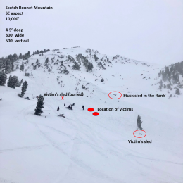
On Monday, December 27th, two snowmobilers were caught and killed in an avalanche on Scotch Bonnet Mountain, north of Cooke City. We have completed our report, which is available HERE.