Good morning. This is Doug Chabot with the Gallatin National Forest Avalanche Forecast on Thursday, January 6th at 7:00 a.m. This information is sponsored by Chad Bunting-Financial Advisor-Edward Jones, Suzy Hahn: Montana Mountain Real Estate Cooke City and the local BWAGs. This forecast does not apply to operating ski areas.
Since 5 a.m. yesterday morning 2-4” has fallen and snowfall will continue unabated today. Mountain temperatures are between 0 and +10F with west wind blowing 15 mph and gusting to 30 mph. Wind will stay westerly and blow stronger today with temperatures warming into the teens through tonight. By morning 2-4” will fall around Bozeman, 4-6” in Big Sky to West Yellowstone and 8-12” around Cooke City. The storm will continue into Friday morning in the southern ranges.

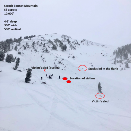
The avalanche danger is rising. Today is snowy and windy with the bulk of the storm occurring during daylight hours. 6-12” is expected to fall and will create instabilities. Wind-loading at most elevations will make thick drifts that could break and avalanche. Additionally, there is a weak layer 6-12” under the surface on some slopes. An avalanche was seen at this depth in Lionhead that broke a day or two prior (photo). A buried layer of faceted crystals or feathery surface hoar is the likely culprit, but the specifics don’t matter, just that a new weak layer is being loaded and avalanching. Outside Cooke City a “whumph” or collapse was felt on Henderson Mountain, a sign of instability. Today’s snow will create dangerous avalanche conditions. Triggering slides in fresh wind drifts or a deeper layer is likely. Travel carefully and do not expose yourself to steep terrain. An error in judgement could be deadly. For today, the avalanche danger is rated CONSIDERABLE on all slopes.

Today’s snowfall is welcome, but carries a heightened risk of avalanches. Wind speed is increasing at all elevations. It is blowing westerly at ridgelines, but will swirl and load slopes at many aspects and elevations. These wind drifts could be triggered. Furthermore, a layer of weak, faceted snow 1-3 feet deep in the Bridger Range is widespread and could avalanche as it did last week on Saddle Peak (details). Today’s snow is falling onto a relatively stable snowpack but we have concerns nonetheless. Ian was on Mt Ellis on Tuesday and took the time to test the snow before he exposed himself to avalanche terrain (video). New snow today creates instabilities with wind-loading. It also creates questions about how it is bonding to the old snow surface and how buried weak layers, some near the ground, are handling this week’s snowfall. Already 8-10” of snow (.8” of snow water equivalent) has incrementally loaded the snowpack since Monday. The avalanche danger is rising and due diligence is required: dig, test and only expose 1 person at a time to avalanche terrain. For today, it is possible to trigger avalanches and the danger is rated MODERATE on all slopes.
If you get out, please send us your observations no matter how brief. You can submit them via our website, email (mtavalanche@gmail.com), phone (406-587-6984), or Instagram (#gnfacobs).
Upcoming Education Opportunities
See our education calendar for an up-to-date list of all local classes. Here are a few select upcoming events and opportunities to check out:
January 20 + Field day. Our popular Avalanche Fundamentals with Field Course is perfect as a refresher or an introduction to avalanches. We are introducing a new format with four pre-recorded lectures to watch at your convenience, a live question and answer session, and a choice of a snowmobile or ski/ board based field day occurring the following two weekends.
Every Saturday near Cooke City, 10 a.m.-3 p.m. FREE snowpack update and transceiver/rescue training. Stop by for 20 minutes or more at the Round Lake Warming Hut.
Read Doug’s latest article on Popular Avalanche Myth’s published by Explore Big Sky.