Good morning. This is Alex Marienthal with the Gallatin National Forest Avalanche Forecast on Sunday, February 13th, at 7:00 a.m. This information is sponsored by Spark R&D and Uphill Pursuits. This forecast does not apply to operating ski areas.
This morning there is no new snow. Temperatures are high teens to mid-20s F, and wind has been west-northwest at 10-20 mph with gusts of 25-40 mph. Today will be mostly sunny with temperatures reaching mid-20s to high 30s F and west wind at 10-20 mph with gusts to 30 mph. Clouds will increase tonight with the next round of snow on track for late tomorrow evening.

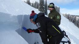
In the mountains near Cooke City a person can trigger an avalanche that breaks 1-1.5 feet deep on layers of weak, sugary facets or surface hoar. These buried weak layers are slow to gain strength. While avalanches are becoming less likely after a week without substantial snowfall, they remain possible and would be large enough to bury a person. Before riding in steep terrain assess the snowpack for these weak layers and pay attention to signs of instability like collapsing, cracking, or recent avalanches. On Friday, strong winds formed fresh drifts which put more weight over these weak layers. Be extra cautious of wind-loaded slopes where the snowpack is probably more unstable. Last weekend I was finding these buried weak layers on almost every slope, so ruling out their presence is difficult (video). If you are unsure of the snowpack stability, avoid slopes steeper than 30 degrees. Today, large avalanches are possible to trigger and avalanche danger is MODERATE.

In the mountains near Bozeman, Big Sky, and West Yellowstone the snowpack is generally stable with small and isolated avalanche hazards to watch for. Yesterday on Buck Ridge near Big Sky I found a generally stable snowpack and saw one small cornice fall avalanche off Cedar Mountain (video, photo). Before riding, skiing, or climbing in steep terrain assess the snowpack for drifts of snow that may remain unstable due to resting on weak, sugary snow. Also watch for small wet loose avalanches on steep, rocky slopes that face the sun (photo), and cornices along ridgelines that could weaken with sun and warm temperatures. These hazards will exist in isolated areas and are unlikely to produce large avalanches, but they would be harmful if they push you into trees, rocks, or over cliffs. Today the avalanche danger is rated LOW.
If you get out, please send us your observations no matter how brief. You can submit them via our website, email (mtavalanche@gmail.com), phone (406-587-6984), or Instagram (#gnfacobs).
Upcoming Education Opportunities
See our education calendar for an up-to-date list of all local classes. Here are a few select upcoming
February 19, Women's only Companion Rescue Clinic sponsored in partnership with SheJumps! Register Here.
March 4, Companion Rescue Clinic with the Bozeman Splitfest. Information and registration HERE.
Every Saturday near Cooke City, 10 a.m.-3 p.m. FREE snowpack update and transceiver/rescue training. Stop by for 20 minutes or more at the Round Lake Warming Hut.
A detailed report on the avalanche fatality at Ski Hill in Lionhead is HERE, a video summary is on our YouTube channel and the incident is recorded on our Accident Reports page.