Good morning. This is Dave Zinn with the Gallatin National Forest Avalanche Forecast on Tuesday, March 1st, at 7:15 a.m. This information is sponsored by Blitz Motorsports and Yamaha and Uphill Pursuits. This forecast does not apply to operating ski areas.
This morning temperatures range from 20 degrees F to the mid 30s F. Strong winds are blowing 15-35 mph from the west to southwest and the mountains near Big Sky and Cooke City received 1-2” of new snow. Today, temperatures will be in the low 30s F to mid 40s F with snow levels between 7,000-8,000’ elevation. Winds will be 20-30 mph from the southwest and the mountains will receive a trace to 2” of snow by tomorrow morning.

Strong winds are blasting the mountains around Bozeman, Big Sky and West Yellowstone, drifting snow onto weak layers buried 6-18” deep and making human-triggered avalanches possible. The Big Sky and Taylor Fork areas received 2” of new snow last night providing a little more ammunition for the wind. Yesterday, Doug got blasted by blowing snow in his video discussing instabilities related to wind-loading in the northern Bridger Range. Way to go the extra mile, Doug.
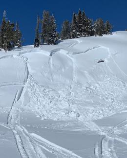
Yesterday, a group turned back from snowboarding a steep line in Hyalite Canyon when they found hard wind slabs covering their objective. Sunday, skiers near Flanders Mountain reported shooting cracks and thin wind slabs (photos and details). Saturday, four separate groups triggered avalanches breaking 8-18” deep and up to several hundred feet wide in the Bridger Range (northern Bridgers avalanches 1, 2, 3, Mount Baldy avalanche). Similar conditions exist in the mountains from Bozeman through West Yellowstone.
On non-wind-loaded slopes, you will find generally stable conditions but slopes unaffected by the wind are getting harder to find (video).
Finally, with high temperatures in the mid 40s F and the possibility of light rain at lower elevations, watch for increased moisture in the upper snowpack and isolated wet snow avalanches.
The danger is MODERATE. Avoid slopes with signs of recently wind-drifted snow and instabilities like cracking or collapsing and test the snowpack before considering steep terrain.
Skiers and riders triggered at least five avalanches breaking 12-24” deep last weekend in the mountains around Cooke City (avalanche activity list). Additionally, Alex was climbing Scotch Bonnet on Sunday, when he heard a loud “whumph” that communicated the message of unstable snow to him and his partner (video). The two inches of new snow will not significantly change stability. But winds are gusting to 40 mph from the southwest are drifting snow and exacerbating the existing instabilities related to persistent weak layers in the top two feet deep in the snowpack.
While smaller slides related to wind-drifting are the most likely problem today, dangerous avalanches like the last week’s slide on Mount Abundance and the recent fatal avalanche near Miller Mountain remain possible (Miller Mountain fatality video, Mt. Abundance video, details). Turn back if you notice any signs of instability and dig down to test weak layers buried a couple of feet deep.
Today, the danger will be most acute on slopes with recent or ongoing wind-loading. The danger is MODERATE.
If you get out, please send us your observations no matter how brief. You can submit them via our website, email (mtavalanche@gmail.com), phone (406-587-6984), or Instagram (#gnfacobs).
Upcoming Education Opportunities
See our education calendar for an up-to-date list of all local classes. Here are a few select upcoming events.
March 4, Companion Rescue Clinic with the Bozeman Splitfest. Information and registration HERE.
Every Saturday near Cooke City, 10 a.m.-3 p.m. FREE snowpack update and transceiver/rescue training. Stop by for 20 minutes or more at the Round Lake Warming Hut.
A detailed report on the avalanche that killed a snow biker outside Cooke City on February 19th is posted online. The video describing the avalanche can be viewed here.