Good morning. This is Doug Chabot with the Gallatin National Forest Avalanche Forecast on the Winter Solstice, Wednesday, December 21st at 7:00 a.m. This information is sponsored by Blitz Motorsports and Yamaha and Montana State Parks. This forecast does not apply to operating ski areas.
You are forgiven if you already thought it was winter. Today’s solstice will leave no doubt. Since yesterday morning 14” of snow has fallen in Cooke City, 10” in the southern ranges and 2-5” around Bozeman and Big Sky. Wind is very strong out of the SW-W averaging 20-40 mph with gusts of 50-60 mph. This morning 3-6” will fall in the north and Cooke City, with 2-4” in the southern ranges. Temperature will spiral downward to -20F to -30F by tomorrow morning.

Cooke City is getting hammered by snow and wind. In the last 48 hours 20” of snow fell (1.2” snow water equivalent, SWE) and SW wind gusting to 47 mph. Triggering avalanches is likely today. Any avalanche is bad news and triggering a slide deep in the snowpack is even worse. Ian and Dave are in Cooke City, and yesterday they were skeptical about getting onto steep terrain (video), and today they must be downright worried. Besides new snow avalanche danger they found weak, faceted snow buried 4-5 feet deep that could be triggered if a skier or rider hit a thin area of the slope. We recommend staying out of avalanche terrain as the danger is rated CONSIDERABLE.
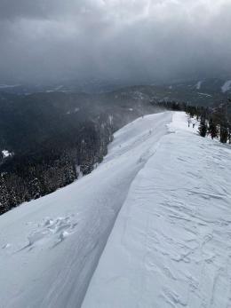
In the last 24 hours the Lionhead area picked up 10” of snow (.4-.5” SWE). Wind is strong and drifting snow. Yesterday, I skied above Hebgen Lake and found a poor snowpack structure which is similar to many slopes in our forecast area (video). Weak, faceted snow is underneath thicker slabs, a real-world jenga tower. Today’s snow and wind-drifting will make it likely to trigger avalanches. Stay clear of drifts and look for signs of instability like whumpfing (collapsing) as you ride or ski, or shooting cracks, both telltale signs that you are very close to triggering a slide. For today, the avalanche danger is rated CONSIDERABLE on all slopes.
At 6 a.m. the Bridger Range had 5” of snow, 3” around Big Sky and 1” in Hyalite. Wind is SW-W at 30-50+ mph. Yesterday a skier noticed a shallow wind-slab avalanche in Beehive Basin (observation) from recent wind-loading. Another concern is a weak layer of faceted snow in the bottom half of the snowpack. Dave and I were in Beehive/Bear Basins on Sunday and agreed that although the facets are widespread, their instability is not. However, an unlucky person could trigger a slide on these facets. Others reached a similar conclusion on Divide Peak on Monday (observation), as well as Ian and Alex in the northern Bridger Range on Saturday (video). New snow and wind will create dangerous conditions, especially on slopes that are wind-loaded. Look for signs of instability and dig, test and assess the snowpack. Slopes that were stable yesterday might not be today. For today, the avalanche danger is rated CONSIDERABLE on wind-loaded slopes and MODERATE on all others.
If you get out, please share avalanche, snowpack or weather observations via our website, email (mtavalanche@gmail.com), phone (406-587-6984), or Instagram (#gnfacobs).

In the last 24 hours 4” of snow has fallen. Wind is also strong and drifting snow. Weak, faceted snow is underneath thicker slabs and wind-drifting adds weight on top of the weak snow. Triggering avalanches on these slopes is likely. Stay clear of thicker drifts and tune in to signs of instability like whumpfing (collapsing) as you ride or ski, or shooting cracks, both telltale signs that you can trigger a slide.
Upcoming Avalanche Education and Events
Our education calendar is full of awareness lectures and field courses. Check it out: Events and Education Calendar.
January 4 + field day on January 7 or 8, Avalanche Fundamentals for Snowmobilers, Information and pre-registration HERE.
January 4 + field day, Avalanche Fundamentals for Skiers and Snowboarders, Information and pre-registration HERE.
Every Saturday, 10 a.m - 2:00 p.m. Avalanche Rescue Training, drop in for any amount of time. Round Lake Warming Hut, Cooke City. Free.
Please consider donating to the Friends of GNFAC Annual Fundraiser.
Send us your observations. They do not have to be fancy, just a few sentences. Did you see any avalanches? How much new snow? Is the wind blowing and drifting snow? Pictures, snowpits and stability test scores are also welcome, but not necessary. You can help us fill in the gaps of our field work.