Good morning. This is Dave Zinn with the Gallatin National Forest Avalanche Forecast on Wednesday, March 1st at 7:00 a.m. This information is sponsored by BWAGs, Pine Edge Cabins and the FUGOWEE Snowmobile Club. This forecast does not apply to operating ski areas.
This morning, temperatures are in the single digits F. The winds dropped off and are currently 5-15 mph from the southwest to the southeast. Cooke City and West Yellowstone received 3-5” of new snow, with a trace to an inch around Bozeman and Big Sky. Today, temperatures will be around 20 degrees F with 5-10 mph winds working around the compass. Cooke City and West Yellowstone will receive 1-3” of snow by morning, with a trace to an inch near Bozeman and Big Sky.

In the last 24 hours, the mountains around West Yellowstone received 3” of snow, equal to 0.2” of snow water equivalent (SWE). This is on top of nearly 3’ of snow that fell incrementally in the last eight days. Last night winds averaging 20-35 mph blew fresh snow into drifts where avalanches breaking several inches to a few feet deep are likely today. Yesterday, Doug and his partner rode at Lionhead and explicitly warned that the nice fluffy powder was primed to get blown into drifts sensitive to human triggers (video). Identify and avoid wind-loaded slopes. Use environmental clues to predict which slopes were loaded by last night’s wind.
Dig and test for instability in and immediately below the recent snow (3’ deep) before riding in non-wind-loaded terrain. The avalanche danger is CONSIDERABLE on wind-loaded slopes and MODERATE on all others.

The mountains around Cooke City received 5” of new snow equal to 0.3” of SWE, and the winds are light. Near-constant snowfall since Friday has added up to two feet of fresh snow, and strong winds transported recent snow into thick drifts where triggering an avalanche is most likely (weather and avalanche log). Since Saturday, four people have been caught and partially buried in avalanches; luckily, no one was injured (Town Hill - 2 partially buried, Mt. Abundance - partial burial, Round Lake - partial burial). Groups of riders and skiers reported many large, natural avalanches documented in our Avalanche Activity Log (Pilot Creek avalanche video). On Monday, Alex and I rode north of Cooke City and described our concerns, especially about wind-loaded slopes (video).
Be suspicious of commonly wind-loaded terrain, slopes with signs of recent wind-loading, and watch for signs of instability. Dig and test the upper three to four feet of the snowpack before engaging with avalanche terrain, whether wind-loaded or not. The avalanche danger is MODERATE.
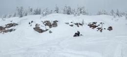
The Bridger, Gallatin, and Madison Ranges received a trace to an inch of new snow in the last 24 hours. Our primary concern is avalanches breaking several inches to 2 feet deep below or within recent drifts or snow. Yesterday, a snowmobiler in Cabin Creek climbed a small slope, triggering an avalanche that broke 100’ wide and 20” deep (photos and details). Similar avalanches are possible today. Last Friday, a cornice collapsed in Bear Basin (photo and details), and large, natural avalanches on Mount Bole, Mount Blackmore and Fan Mountain show us the larger end of the spectrum.
Heed warnings provided by signs of instability and test the upper few feet of the snowpack before considering steep slopes. Today, human-triggered avalanches are possible, and the danger is MODERATE.
Please share avalanche, snowpack or weather observations via our website, email (mtavalanche@gmail.com), phone (406-587-6984), or Instagram (#gnfacobs).

Dangerous avalanche conditions exist on recently wind-loaded slopes. The Centennial Range received 16-20” of snow in the last three days, with more on the way. Winds gusted to 60 mph on Sawtelle Peak last night before calming early this morning. Strong winds blew fresh snow into drifts where avalanches breaking several inches to a few feet deep are likely today. Predict which slopes were loaded by last night’s wind and avoid them. Dig and test for instability in and below the recent snow (3’ deep) before riding in non-wind-loaded terrain.
Upcoming Avalanche Education and Events
Our education calendar is full of awareness lectures and field courses. Check it out: Events and Education Calendar.
March 3, 9 a.m.-3 p.m., Bozeman Splitfest - Companion Rescue Clinic. Classroom session followed by a field session. More information and registration HERE.
March 3-5, Bozeman Splitfest. More info and register here.
March 3 & 4, Companion Rescue Clinic. Online classroom session Friday evening followed by a field session from 10 a.m.-2 p.m. Saturday. More information and registration HERE.
March 9, 6 p.m.-7 p.m., 1-Hour Awareness - Spring conditions. FREE at REI Bozeman.
March 10 & 11, SheJumps - Women’s Companion Rescue Clinic. Online classroom session Friday evening followed by a field session from 10 a.m.-2 p.m. Saturday. More information and registration HERE.
Every Saturday, 10 a.m. - 2:00 p.m. Avalanche Rescue Training, drop in for any amount of time. Round Lake Warming Hut, Cooke City. Free.
Loss in the Outdoors, is a support group for those who have been affected by grief and loss related to outdoor pursuits. Check out the link for more information.
Tragically, last Thursday in Wyoming a snowmobiler was buried and killed in an avalanche. Over the weekend in Colorado, two skiers and one snowmobiler were buried and killed. Current details for these accidents are available HERE.