Good morning. This is Dave Zinn with the Gallatin National Forest Avalanche Forecast on Monday, March 6th at 7:00 a.m. This information is sponsored by Mystery Ranch and onX. This forecast does not apply to operating ski areas.
This morning, temperatures are in the single digits F with 5-20 mph winds from the east to south, except in Cooke City where they are from the northeast. The Bridger Range received 11” of fresh snow with 2-4” everywhere else. Today, temperatures will be in the teens to 20s F, the wind will shift back to the southwest to west later this morning at 5-15 mph and the mountains will receive 3-6” of snow.

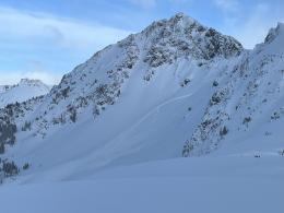
Dangerous avalanche conditions exist in the mountains across the advisory area. Eleven inches of fresh snow in the Bridger Range and 2-5” elsewhere adds to six straight days of cumulative loading. West Yellowstone and Cooke City have received near constant snowfall for more than two weeks. Consider two problems today. The first, is deep slab avalanches that could fail multiple feet deep. The second, is slides within the new and wind-drifted snow. The latter is slightly less dangerous but more likely. The former is less likely but potentially unsurvivable.
Deep slab avalanches keep us on edge and should keep you on edge too because signs of instability before triggering an avalanche are less likely, snowpack tests are often unreliable and multiple people may ski or ride a slope before it releases. Manage deep slab avalanche by avoiding slopes over 30 degrees and minimizing time below them. Staying in lower elevation or non-wind-loaded terrain reduces but does not eliminate your chances of triggering a deep slab avalanche.
In Cooke City, five human-triggered avalanches have failed in the last week, with four partial burials (Miller Mountain, Town Hill, Round Lake, Mt. Abundance). Doug investigated the most recent skier-triggered avalanche that failed 4 feet deep on Thursday and found that it broke on a layer of buried surface hoar on a slope barely over 30 degrees steepness (video). This weekend, skiers triggered a four-and-a-half-foot deep avalanche on Hyalite Peak that caught and partially buried one of them (details and photos). Outside our advisory area in the Absaroka Range, a number of people skied and boarded a slope before one triggered a large slide and was injured, requiring helicopter evacuation (details and photos). Other recent avalanches across the advisory area are a clear sign that buried weak layers are a real concern (Buck Ridge Rider triggered, Cabin Creek rider triggered, Natural in Sage Basin).
Remember also the threat posed by smaller avalanches in the new and wind-drifted snow. Yesterday, Alex saw cracks shooting from the skis of his sled at Buck Ridge (video), and a group in the Northern Bridger Range found sensitive slabs breaking 5-10” deep (details and photos). On Saturday, a pair of skiers triggered a wind slab on Elephant Mountain in Hyalite Canyon in high-consequence terrain (photos and details). Move on if you observe signs of instability and consider terrain features like trees, cliffs or gullies that increase the consequences of getting caught in a small slide.
The danger is CONSIDERABLE.
Please share avalanche, snowpack or weather observations via our website, email (mtavalanche@gmail.com), phone (406-587-6984), or Instagram (#gnfacobs).

Dangerous avalanche conditions exist in Island Park. Six inches of snow fell yesterday, adding to over two weeks of nearly constant loading (recent observation). Slab avalanches failing multiple feet deep are possible. The most reliable management strategy relative to deep slab avalanches is avoiding slopes over 30 degrees. Staying in lower elevation or non-wind-loaded terrain reduces but does not eliminate your chances of triggering a deep slab avalanche.
Slides within the new and wind-drifted snow are likely. Move to different terrain if you observe signs of instability and consider terrain features like trees, cliffs or gullies that increase the consequences of getting caught in a small slide.
Upcoming Avalanche Education and Events
Our education calendar is full of awareness lectures and field courses. Check it out: Events and Education Calendar.
TODAY! March 3-5, Bozeman Splitfest. More info and register here.
March 9, 6 p.m.-7 p.m., 1-Hour Awareness - Spring conditions. FREE at REI Bozeman.
March 10 & 11, SheJumps - Women’s Companion Rescue Clinic. Online classroom session Friday evening followed by a field session from 10 a.m.-2 p.m. Saturday. More information and registration HERE.
Every Saturday, 10 a.m. - 2:00 p.m. Avalanche Rescue Training, drop in for any amount of time. Round Lake Warming Hut, Cooke City. Free.
Loss in the Outdoors, is a support group for those who have been affected by grief and loss related to outdoor pursuits. Check out the link for more information.
A list of all avalanche activity from our forecast area can be viewed HERE.