Good morning. This is Ian Hoyer with the Gallatin National Forest Avalanche Forecast on Friday, March 10th at 7:00 a.m. This information is sponsored by Blitz Motorsports and Yamaha and Avalanche Alliance. This forecast does not apply to operating ski areas.
At 6 a.m., there are 7” of new snow in the Lionhead area and 2-3” across most of the rest of the advisory area (excepting the Bridger Range which stayed dry). Winds are 20-40 mph out of the south and southwest with gusts of 35-55 mph. Temperatures are in the teens F. South-southwest winds will ramp up even more during the day and we could see gusts into the 60s and 70s mph. High temperatures will generally be in the high 20s F (mid-30s F in the Bridgers). 5-10” of new snow will accumulate near West Yellowstone and Cooke City by tomorrow morning, with the bulk falling during daylight hours today. 3-5” will fall near Big Sky and 2-4” near Bozeman.

New snow and strong winds are adding load to a snowpack that was already teetering on the edge of instability. As snow accumulates today, you will be able to trigger avalanches in the new and windblown snow. Be on the lookout for and avoid steep slopes with thick fresh drifts. Very strong winds will be loading slopes at all elevations, including slopes that are not usually wind affected. New snow slides could easily be large enough to bury you by themselves and definitely merit caution, but also don’t let them distract you from the much more dangerous deep slab concern.
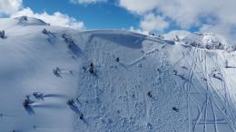
Last week, steady, incremental loading led to several natural and human triggered avalanches breaking on persistent weak layers buried deep in the snowpack (Cooke City video). Today’s loading event makes it more likely for you to trigger one of these large, likely unsurvivable, deep slab avalanches. Getting on steep slopes while a snowpack that has shown the propensity for deep slab avalanches is actively being loaded is tempting fate. Avoid riding on or under slopes steeper than 30 degrees today.
Human triggered avalanches are likely and the avalanche danger is CONSIDERABLE.

A couple inches of new snow isn’t enough to bump up the danger rating, but by no means does that mean conditions are safe. The avalanche concerns are the same here as in the areas getting more snowfall today, but slides in the new snow will be smaller and avalanches breaking deeper are less likely. If you are planning on riding in avalanche terrain, watch out for wind drifts and dig to test recently buried weak layers in the upper snowpack (observation documenting a new weak layer in Hyalite). As the potential still exists for huge, deep slab avalanches (Hyalite video) simply continuing to avoid steep slopes all together is not at all an unreasonable plan. Any potential for deep slab avalanches is particularly scary because signs of instability before an avalanche are often non-existent, stability tests aren’t as effective and many people may travel across a slope before someone hits the wrong spot, and it releases.
Triggering large avalanches remains possible and the avalanche danger is rated MODERATE.
Please share avalanche, snowpack or weather observations via our website, email (mtavalanche@gmail.com), phone (406-587-6984), or Instagram (#gnfacobs).

Heavy snowfall and very strong winds today will dramatically increase the avalanche danger. We were a hair's breadth away from issuing an avalanche warning. The more new snow that falls, the more dangerous conditions will become. Avalanches could break in today’s new and wind drifted snow, within the snow that fell last week, or potentially on weak layers deeper in the snowpack. Take a huge step back in your terrain choices today. Avoid riding on or beneath steep slopes.
Upcoming Avalanche Education and Events
Our education calendar is full of awareness lectures and field courses. Check it out: Events and Education Calendar.
Today! March 10 & 11, SheJumps - Women’s Companion Rescue Clinic. Online classroom session Friday evening followed by a field session from 10 a.m.-2 p.m. Saturday. More information and registration HERE.
Every Saturday, 10 a.m. - 2:00 p.m. Avalanche Rescue Training, drop in for any amount of time. Round Lake Warming Hut, Cooke City. Free.
Loss in the Outdoors is a support group for those affected by grief and loss related to outdoor pursuits. Check out the link for more information
A list of all avalanche activity from our forecast area can be viewed HERE.