Good morning. This is Dave Zinn with the Gallatin National Forest Avalanche Forecast on Tuesday, March 5th at 7:00 a.m. Today’s forecast is sponsored by Bozeman Splitfest, Cooke City Motorsports and Bridger Bowl. This forecast does not apply to operating ski areas.
Temperatures are in the single digits above and below 0 F this morning, with 10-25 mph winds from the west to the south. The mountains received 1-3” of new snow across the advisory area, with 5” in Island Park. Today, temperatures will be in the upper teens to low-20s F, with 15-25 mph winds from the southwest to the northwest. By tomorrow morning, the mountains near Cooke City, West Yellowstone and Island Park will have 8-12” of new snow, with 5-8” near Big Sky and the Northern Gallatin Range and 1-3” in the Bridger Range.

All Regions
Dangerous avalanche conditions across the advisory area have been the norm for the better part of two months, and today is no different. An incoming snowstorm will add weight to a snowpack structure that has proven itself untrustworthy (avalanche and weather log). Avalanches failing 1-2 feet deep within the new and wind-drifted snow are likely, and large enough to bury or injure backcountry travelers. However, very large avalanches breaking 3-4+ feet on persistent weak layers remain the primary concern.
I don’t like surprises, and I was surprised yesterday at Bacon Rind when my partners and I came across two recent avalanches on slopes that I had not previously seen slide. The avalanches broke over 100 feet wide and 3-4 feet deep and ran a short distance before the terrain constrained them. To be clear, the slopes are 29-34 degrees, thus avalanche terrain, but the pitches are very small, and both were unusual events in this location. On a larger slope, getting caught by a similar slide would be terrifying or worse (video).
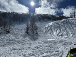
Alex and Ian spent the weekend documenting avalanche activity in Tepee Basin (video) and the northern Bridger Range, where they saw many small slab and loose snow avalanches (photo) and a pair of larger slides that failed 2-3 feet deep (video, photo, photo).
Many recent avalanches have been the largest of the season, including slides in Hyalite Canyon that broke across an entire mountain bowl (Info and photos), in McAtee Basin that failed nearly to the ground (observation), on Henderson Mountain that slid to the valley floor breaking trees along the way (observation, photo), on Fan Mountain (observation), and many more around Cooke City (photos and observation, 2).
Avoidance is critical, and the only way to ensure this is to avoid backcountry terrain steeper than 30 degrees and avalanche runout zones. Build in wider margins for error during a season that dishes out surprises. The danger is CONSIDERABLE.
If you venture out, please fill an observation form. It does not need to be technical. Did you see any avalanches? How much snow is on the ground? Was the wind moving snow? Simple observations are incredibly valuable. You can also contact us via email (mtavalanche@gmail.com), phone (406-587-6984), or Instagram (#gnfacobs).
Upcoming Avalanche Education and Events
Our education calendar is full of awareness lectures and field courses. Check it out: Events and Education Calendar.
March 8-10: Bozeman Splitfest. Check the Bozeman Splitfest website for event details and avalanche education opportunities offered by the Friends of the Avalanche Center.
Every weekend in Cooke City: Friday at The Antlers at 7 p.m., Free Avalanche Awareness and Current Conditions talk, and Saturday from 10 a.m.-2 p.m. at Round Lake Warming Hut, Free Rescue Practice.
Loss in the Outdoors is a support group for those affected by loss and grief related to outdoor pursuits. Check out the link for more information.
On Friday there were two snowmobilers killed in separate avalanches, in Washington and northern Idaho. Our deepest condolences go out to the families, friends, and all involved.