Good morning. This is Doug Chabot with the Gallatin National Forest Avalanche Forecast on Thursday, March 7th at 7:15 a.m. Today’s forecast is sponsored by Montana State Parks and Spark R&D. This forecast does not apply to operating ski areas.
An inch of snow fell yesterday morning in Cooke City and Island Park before the skies cleared. Wind has calmed with only occasional westerly gusts of 15 mph. Mountain temperatures are 5F and will rise to the high 20’s today under mostly calm and sunny skies. No snow is expected until early next week.

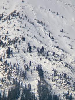
Yesterday we issued an avalanche warning in Lionhead, Cooke City and Island Park where 4-5 feet of snow fell in the last week (3.6-4.8” SWE). Avalanches came crashing down and a webcam recorded a large natural avalanche on the outskirts of Cooke City (video). Observers also saw a large natural on Mount Abundance north of Cooke City (photo) and another party saw a large natural and many smaller slides at Lionhead (observation). Natural slides are not expected today, but triggering a large avalanche is still likely. Dangerous avalanche conditions exist. Looking at the photo of a very large slide in Hyalite still causes my palms to sweat 4 days later. And let’s not forget that Dave found wild instability at Bacon Rind on Monday. Low-angled and small slopes broke 3-4 feet deep (observation and video).
In typical years the snowpack can stabilize within a day or two of loading. Not this year, it’s taking longer. At the moment we are conservative in our actions in the field and in the forecast. We are not touching avalanche terrain today; our uncertainty is high.
The avalanche danger is rated CONSIDERABLE.

The Bridger Range received 3 feet of snow in the last week (2.8” SWE) which was blown around and responsible for an avalanche warning on Sunday. Since then, slopes have become less hair trigger and no significant avalanche activity has been reported. People are heading into avalanche terrain without consequence…so far. The snowpack is unstable on some slopes and people can still trigger slides. Signs of instability are mostly absent and stability tests have been showing “false-stable” conditions, so assessing slopes just got a lot trickier. If you decide to enter avalanche terrain, go gradually and start with less steep and smaller slopes. Only expose 1 person at a time in avalanche terrain so everyone else is poised to rescue if your assessment was wrong. Be smart, be careful and be ready.
The avalanche danger is rated MODERATE. Triggering large avalanches is still possible.
An Editorial: I am most worried about Saddle Peak. I ask myself, “Could it slide?” and my answer is, “Yes”. Its snowpack is no different than the other peaks in the range, but it gets a magnitude of more traffic. More traffic means more potential triggers and more people being exposed. Tracks on a slope are not indicative of stability. An avalanche on Saddle Peak in 2010 took out hundreds of tracks.
If you venture out, please fill an observation form. It does not need to be technical. Did you see any avalanches? How much snow is on the ground? Was the wind moving snow? Simple observations are incredibly valuable. You can also contact us via email (mtavalanche@gmail.com), phone (406-587-6984), or Instagram (#gnfacobs).
Upcoming Avalanche Education and Events
Our education calendar is full of awareness lectures and field courses. Check it out: Events and Education Calendar.
THIS WEEKEND, March 8-10: Bozeman Splitfest. Check the Bozeman Splitfest website for event details and avalanche education opportunities offered by the Friends of the Avalanche Center.
Every weekend in Cooke City: Friday at The Antlers at 7 p.m., Free Avalanche Awareness and Current Conditions talk, and Saturday from 10 a.m.-2 p.m. at Round Lake Warming Hut, Free Rescue Practice.
Loss in the Outdoors is a support group for those affected by loss and grief related to outdoor pursuits. Check out the link for more information.
An Editorial by Doug: I am most worried about Saddle Peak. I ask myself, “Could it slide?” and my answer is, “Yes”. Its snowpack is no different than the other peaks in the range, but it gets a magnitude of more traffic. More traffic means more potential triggers and more people being exposed. Tracks on a slope are not indicative of stability. An avalanche on Saddle Peak in 2010 took out hundreds of tracks.