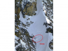
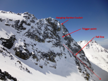
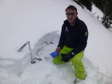
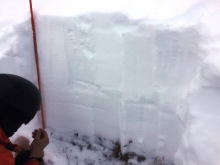
Advisory Archive
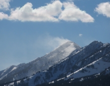
Over the past 24 hours the northern Gallatin Range (Hyalite area) received 10 inches of low density snow totaling .5 inches of SWE. The mountains around Big Sky, West Yellowstone and Cooke City picked up between 5-7 inches, while the Bridger Range squeezed out about 4 inches. This morning, temperatures range from the single digits to low teens F and winds are blowing 15-25 mph out of the W-NW. Today, scattered snow showers will continue in the mountains with additional 1-2 inches possible. Temperatures will slowly warm into the low to upper teens F and winds will continue to blow 15-25 out of the W-NW. By this evening snow showers will taper off and skies will become mostly clear. Temperatures will be cold tonight dropping into the single digits, but Saturday will provide plenty of sunshine and temperatures in the 20s F.


Winter made an appearance this morning and delivered four inches of snow to the Bridger Range and three inches at Big Sky. Other areas did not record any significant snowfall. Temperatures are dropping this afternoon with lows in the teens and highs in the 30s F expected through the week. Scattered snow showers are expected from Tuesday through Thursday with an accumulation of 4-6” on Thursday night. Winds will be between 30 and 50 mph from Tuesday through Wednesday with gusts up to 60 mph on Wednesday near Bozeman.

It’s warm, partly cloudy and windy out there. Mountain temperatures are reaching the low 30s as west to southwest winds average 20-30 mph with gusts of 40. The winds will continue into tonight and calm tomorrow. Mountain temperatures will be slightly above freezing through the weekend with Saturday being the warmest and sunniest. There’s a chance of flurries Sunday night followed by below freezing temperatures next week with more snow possible on Thursday or Friday. If you are craving one last day of rock climbing or mountain biking, this weekend might be it.
Yesterday’s storm favored the Bridger Range, which picked up 5” of new snow. The mountains around Big Sky, West Yellowstone and Cooke City received 2-3” of new snow. This morning, temperatures range from the single digits to low teens F and winds are increasing out of the west-southwest, with the exception of Cooke City where winds are blowing out of the northwest. The ridge weather station at Bridger Bowl is showing wind gusts in excess of 40 mph, while winds around Hyalite and Big Sky are gusting close to 30 mph. Today, temperatures will warm into the 20s F and winds will continue to be moderate to strong out of west. Skies will be partly cloudy this morning, but will become increasingly cloudy by this afternoon. A weak weather system will push into the area later today producing a slight chance of mountain snow showers this evening. The mountains could pick up a trace to one inch of new snow by tomorrow morning. Warmer and drier conditions look to be on hand for the weekend.
At 5:30 a.m. light snow flurries are still falling but will end soon. Overnight the mountains picked up 2-4 inches of snow with west to northwest winds blowing 15-20 mph. Currently, temperatures are in the mid-teens. Today will turn sunny with westerly winds blowing 20 mph. The weekend will be dry and sunny with daytime temperatures reaching the upper thirties. Our next snow storm will roll into our area late Monday. Let’s keep our fingers crossed for more El Nino action.

Winter is here. Since Monday night, the mountains from Bozeman to West Yellowstone received around 1.2 inches of snow water equivalent (SWE), giving us a snow depth up to 18 inches. Since Sunday, the mountains around Cooke City received 2.6 inches of SWE, bringing their snow depth to 26 inches. Southerly winds during the storm were moderate with gusts of 40 mph. The exception is the Bridger Range where winds were light and easterly. Temperatures this morning were in the high teens F in most mountain locations.
Winds over the next few days will be out of the west to northwest at 20 to 35 mph. Another 2-4 inches of snow is expected in the mountains around Bozeman and Big Sky Thursday night, with slightly larger amounts near Cooke City. This weekend will be dry with our next chance for precipitation early next week. Mountain temperatures over the next few days will be in the 20s F and reach the upper 30s F by Sunday.
Driving into Bozeman this morning it’s clear that snow levels dropped to around 6,000 ft. overnight. Although local Snotel sites aren’t showing much in the way of accumulation, I’m guessing a few inches of dense snow fell at higher elevations. In the mountains around Cooke City, Fisher Creek Snotel site is reporting three inches of accumulated snow. I wouldn’t be surprised if 4-6 inches fell at higher elevations in this area. Today, mountain snow showers will linger through the morning, but no real accumulation is expected. A weak ridge of high pressure begins to build this afternoon producing warmer and drier conditions for Wednesday. Another weak storm system could impact the area later in the week.

My oh my, a snowstorm. Yesterday afternoon the sky darkened, temperatures dropped, winds calmed and snow fell. This morning there are 5-6 inches in the mountains south of Bozeman to Big Sky and Carrot Basin. The Bridger Range and mountains around West Yellowstone and Cooke City got 1-2 inches. Scattered snowfall may add another inch or two before the storm exits later this morning. Winds are 10-20 mph out of the west to northwest and mountain temperatures range from 10-20F.
The rest of the week will be sunny with temperatures reaching the 50s in the mountains. The weekend and early next week will be slightly cooler and partly sunny, so enjoy the new snow while it’s here, because it will melt fast.