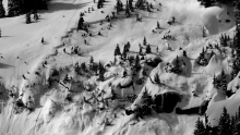
Advisory Archive
Overnight the Bridger Range received an inch of snow and the mountains near Big Sky received 3-4 inches. Many SNOTEL sites stopped reported data yesterday evening, but I think most other places received 2-4 inches. This morning temperatures had dropped into the mid to high teens F. Strong winds were averaging 20-30 mph and gusting to 50 mph mostly from the W. Today the sun should appear by afternoon and temperatures will rise into the high 20s and low 30s F. Winds should ease by afternoon and blow 5-15 mph. Sunday will have strong winds and warm temperatures. Then Monday will have cooler temperatures and more snow. Welcome to spring!


This morning mountain temperatures were in the low 20s F. Winds were blowing from the SW at 10-15 mph gusting to 20 mph. A storm over western Washington this morning will bring clouds this afternoon and more snow tonight. High temperatures today should reach the mid 30s F and winds should blow 10-15 mph from the SW. 2-4 inches of snow should fall by tomorrow morning.

Temperatures are near twenty degrees under clear skies this morning. Winds are west to southwest at 15-25 mph. Today will be sunny and warm with mountain temperatures reaching the high thirties by midafternoon. Winds will remain moderate and tonight will be clear again. Today is a skin burning SPF 50 type of day.
Under clear skies temperatures are in the teens with west to southwest winds averaging 15-20 mph and gusting to 30 mph. Today will be sunny and winds will be moderate from the southwest as mountain temperatures rise to the upper thirties. The rest of the week looks to be sunny, warm and spring-like.

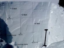
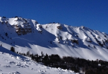
Snowfall has been heavy, wet and plentiful. 14-20+” has fallen at the higher elevations, but even more important is the weight of this new snow which is measuring 1.5-2” of snow water equivalency (SWE), a very heavy 24-hour burden for almost all of our areas. Mountain temperatures are near 20F and winds are westerly at 20-40 mph. A few more inches will fall before the storm ends early this morning. Partly cloudy skies with west winds blowing 20-30 mph are in store for us today with sunny skies forecasted the rest of the week.


Over the past 24 hours 1-3 inches of snow fell in the mountains around Big Sky, West Yellowstone and Cooke City. The mountains around Bozeman picked up a trace to one inch. At 4 a.m. mountain temperatures are in the upper 20s to mid-30s F and winds are blowing 15-25 out of the WSW with ridge top gusts reaching 50 mph in Hyalite and Big Sky.
Today, an active weather pattern will remain in place as a strong storm system pushes in from the west. Precipitation will start this morning producing valley rain and mountain snow. Temperatures will be the warmest before noon, but will gradually drop through the day. Snow levels should reach the valley floor by late afternoon. Winds will gradually shift to the NW which will favor the northern mountains with snowfall amounts. The mountains around Bozeman, Big Sky and Cooke City should see 8-10 inches of new snow by tomorrow morning. The southern Mountains will likely pick up 4-6 inches.
At 4 a.m. temperatures are in the high 20s to mid-30s F and winds are blowing 15-25 mph out of the WSW with ridge top gusts reaching close to 50 mph. Today, temperatures will remain above average with highs in the upper 30s to low 40s F. Winds will continue to blow 20-30 mph out of the WSW with ridge top gusts reaching close to 50 mph. Skies will remain mostly cloudy as a strong westerly flow pushes moisture into the area. Precipitation is unlikely today, but a developing low pressure system will increase the chance of precipitation tonight and tomorrow. A few inches of snow are possible by tomorrow morning with up to a foot possible by Tuesday morning.

Overnight no new snow fell. This morning temperatures are in the upper teens to low 20s F and winds are blowing 10-25 out of the WSW. Today, skies will be mostly clear and temperatures will warm into the high 30s to low 40s F. Winds will blow 10-25 out of the WSW this morning, but will gradually increase with ridge top gusts reaching 40 mph by this afternoon. The current ridge of high pressure will begin to break down this evening and skies will become mostly cloudy by tomorrow morning. However, no precipitation is expected over the next 24 hours.

Yesterday the Bridger Range received 10 inches of heavy snow (15% density) and all other areas received 4-6 inches of similar snow. Low elevation areas received some rain. Temperatures this morning were in the 20s F. Ridge top winds yesterday were blowing 20-30 mph with some gusts of 50 mph. This morning winds had eased and were blowing westerly 10-15 mph gusting to 25 mph. Today temperatures should warm to near 30 F and by afternoon winds should ease a bit more. About 1 inch of new snow should fall today.

Over the past 24 hours the mountains around Cooke City picked up .8 inches of SWE (snow water equivalent) totaling 6-8 inches of high density snow. The mountains around West Yellowstone and Big Sky received .2-.3 inches of SWE equaling a few inches of snow while the mountains around Bozeman picked up a trace to one inch of snow.
This morning temperatures are a few degrees above or below freezing with Brackett Creek Snotel site being the warmest at 39 degrees F. Winds are strongest in the Hyalite area and mountains around Big Sky. Hyalite weather station is recording gusts close to 70 mph while Big Sky is showing gusts around 50 mph out of the WSW. The rest of the advisory area is looking at winds of 10-20 mph with gusts around 30 mph. Today, winds will remain strong out of the WSW and temperatures will warm into the mid to high 30s F. An active weather pattern will make snow showers likely in the mountains around Cooke City and West Yellowstone where an additional 1-3 inches is possible. The northern ranges could see a trace to one inch by this afternoon. Tonight and tomorrow look to be warm, windy and dry.