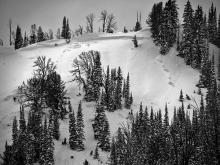
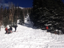
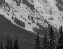
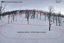
Advisory Archive
Overnight the mountains around Big Sky picked up 3-4 inches of new snow, 1-2 inches fell eslewhere. At 4 a.m. temperatures range between 5-10 degrees above zero F and westerly winds are blowing 10-20 mph with ridge top gusts reaching 40 mph near Big Sky and Hyalite. Today, temperatures will warm into the twenties F and winds will continue to blow 15-30 mph out of WNW. Snow will continue to fall through the day with 2-4 inches possible in the northern ranges and 1-3 in the south by this afternoon. Snowfall intensity will increase this evening with an additional 6-8 inches likely by Monday morning in the mountains around Bozeman, Big Sky and Cooke City. The mountains around West Yellowstone will see an additional 3-5 inches by tomorrow morning.
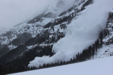
Over the past 24 hours the Bridger Range has picked up 17 inches of new snow. The northern Gallatin Range has received close to a foot while the mountains around Big Sky picked up 4-5 inches. The mountains around West Yellowstone and Cooke City have received 1-3 inches.
At 4 a.m. mountain temperatures are in the single digits above or below zero F and winds are blowing 10-20 mph out of the WNW. Snow will slowly diminish through the morning hours with an additional 1-2 inches possible in the northern ranges. Today, temperatures will warm into the teens F under mostly cloudy skies and winds will remain light to moderate out the WNW. This afternoon and evening look to be dry, but another potent storm system is forecasted to impact southwest Montana starting tomorrow morning. This storm has the potential to drop over a foot of snow in the northern mountains by Monday.

Since yesterday morning the mountains near Cooke City received 6-8 inches of snow, near West Yellowstone 4-6 inches, and near Bozeman and Big Sky 3 inches. Winds were blowing 20-30 mph and gusting to 50 mph from the SW in some places and NW in others. Temperatures ranged from 10 F to 15 F. Today’s forecast is more wind, more snow, and cold temperatures. Westerly winds should average 20 mph and gust to 40 mph. Temperatures may rise to near 20 F but fall this afternoon as cold air descends from the north. By tomorrow morning most areas should get another 1-3 inches. With moisture and cold air coming from the NW for the next few days, it is possible that we could see another good dump in the Bridger Range but these events are hard to forecast. The good news is that winds should finally calm this weekend.
Snow fell yesterday morning and last night. The mountains near Cooke City and the Bridger Range receiving 5-10 inches of snow, the mountains near Big Sky and south of Bozeman received 6 inches, and the mountains near West Yellowstone received a trace. Winds eased just a little this morning and were blowing 15-25 mph gusting to 40 mph from the SW in some places and NW in others. Temperatures had dropped into the single digits F. Today will have more of the same – strong winds and snow. Temperatures will reach the high teens and low 20s F and winds should increase a little this afternoon. Snow will return around midday with 4-5 inches of new snow by tomorrow morning.

Late last night the mountains around Cooke City and West Yellowstone picked up 2-3 inches of new snow while other areas remained dry. This morning mountain temperatures are near 20F with west to southwest winds averaging 25-30 mph and gusting 50-60 mph. Today will be cloudy, windy and snowy. Temperatures will drop into the teens and 2-4 inches of snow will fall during the day.
In the wee hours of the morning the mountains picked up snow: 5” at the Yellowstone Club, 3” outside Cooke City and 1-2” everywhere else. Westerly winds are blowing strong with speeds averaging 20-30 mph and gusts of 50-70 mph at the ridges. Temperatures are in the teens and should warm into the mid-20s today. Skies will become mostly sunny this morning, but cloud up again tonight and drop another 1-3 inches by tomorrow morning.

Yesterday, a fast moving storm system dropped 2-3 inches of high density snow in most locations with the exception of Cooke City which picked 6-8 inches. This morning temperatures are in the teens F and winds are blowing 15-25 mph out of the WSW with ridge top gusts reaching into the 40s. Today, snowfall will be limited to a few passing shows and no real accumulations are expected. The main weather event will be wind, which will continue to blow out of the WSW at 15-30 mph with gusts in the 40s. Temperatures will be above average today with highs climbing into the 30s F under partly cloudy skies.

Since yesterday morning another 6-8 inches of dense snow fell near Cooke City. The mountains around West Yellowstone received 2-3 inches while the mountains around Bozeman and Big Sky picked up 1-2 inches. At 4 a.m. mountain temperatures are in the upper 20s F to low 30s F and winds are strong out of the WSW blowing 15-25 mph with gusts over 40 mph being recorded in most locations. Today, temperatures will only warm a few degrees as a weak cold front moves over the area. Winds will remain strong out of WSW blowing 15-25 mph with gust reaching upwards of 50 mph. Moisture pushing in from the southwest will continue to produce a chance of mountain snow, mainly for the mountains around West Yellowstone and Cooke City where an additional 2-3 inches is possible. Snow will taper off this evening but another round of moisture is forecasted to impact the area tomorrow night into Tuesday.

Since yesterday morning, another 8 inches of dense snow fell near Cooke City, 4-6 inches near Big Sky and Hyalite Canyon, 3-4 inches near West Yellowstone, and 1-2 inches in the Bridger Range. Temperatures this morning ranged from the high teens to mid 20’s F. Westerly winds were averaging 15-25 mph and gusting 40-50 mph. With a warm front approaching SW Montana, temperatures will warm to near 30 F. Winds will blow 15 mph gusting to 25 mph from the SW but will increase tonight as the front passes. More snow will come with 4-6 inches expected near Cooke City and West Yellowstone, 1-3 inches near Big Sky, and a trace near Bozeman.