Good morning. This is Alex Marienthal with the Gallatin National Forest Avalanche Forecast issued on Monday, January 7th at 7:00 a.m. Today’s forecast is sponsored by Bridger Bowl and Montana State Parks. This forecast does not apply to operating ski areas.
Since yesterday morning the mountains near West Yellowstone and Cooke City got 8-9” of new snow, the Bridger Range got a heavy half inch, and Big Sky got a trace. This morning, temperatures are in the teens F and wind is south to southwest at 25-35 mph with gusts of 45-70 mph. Today wind will shift to west-northwest at 35-45 mph. Temperatures will be teens to low 20s F and drop to the single digits F tonight. Light snowfall will continue this morning and the mountains will get 2-4” with 6” possible near Cooke City by tonight.

In the mountains south of Big Sky to West Yellowstone a foot of new snow (.6-1” of snow water equivalent) and strong wind will cause natural avalanches on wind loaded slopes, and avalanches will be easy to trigger on all steep slopes. The snowpack is poorly supported by 1.5’ of weak, sugary facets on the ground (photo), which makes it possible for avalanches to break far and wide. Doug rode into Lionhead Ridge yesterday and found this poor snowpack structure and unstable new snow (video). Eric and I found a similar, slightly weaker snowpack in the southern Madison Range last week (video, video, video). Doug’s video from yesterday shows the weak snow at the ground is getting more stubborn in stability tests, but the real test will be the stress of new snow and fresh wind drifts today.
Avoid riding on steep slopes and through avalanche runout zones today. Avalanche danger is HIGH on wind loaded slopes and CONSIDERABLE on all other slopes.

Since yesterday the mountains near Cooke City got 9” of new snow equal to .6” of snow water equivalent (SWE). Today, more snow is expected and strong wind will continue out of various directions (southwest to northwest). On wind loaded slopes, natural avalanches are possible and fresh drifts of snow will be easy to trigger and can break deeper and wider on buried weak layers (video). On non-wind loaded slopes, loose snow and slab avalanches in the storm snow are likely. These avalanches can also break far and wide where new snow fell on a weak snowpack, such as what Doug found last week south of Cooke (video). Today, avalanches are easy to trigger and avalanche danger is CONSIDERABLE. Danger could rise to HIGH on wind loaded slopes if heavy snowfall continues today.

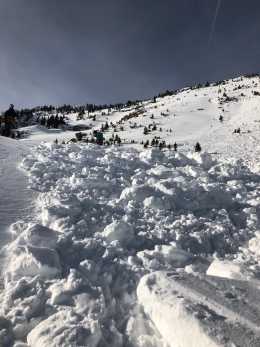
In the mountains near Bozeman and Big Sky, weak, sugary snow that formed in December is buried 1-2’ deep and creates a poor snowpack structure. We received reports of large collapses most days the past week (Activity log, photo). On Saturday, in Middle Basin a skier triggered an avalanche that broke on hollow, sugary snow 1-2’ deep (photo, details) and riders in the northern Bridgers saw a large avalanche (photo). A few inches of new snow today and strong wind will form fresh drifts that are easy to trigger and could break deeper on weak, sugary snow. Avalanche danger is MODERATE. Danger could rise to CONSIDERABLE on wind loaded slopes with more than a couple inches of new snow today.
If you get out and have any avalanche or snowpack observations to share, contact us via our website, email (mtavalanche@gmail.com), phone (406-587-6984), or Instagram (#gnfacobs).
Avalanche Warning
We are issuing an avalanche warning for the Centennial Range due to strong wind and heavy snowfall (1.3+" of SWE) loading a weak snowpack. See the Centennial's regional page for more info.
Avalanche Fatality near Choteau
A snowmobiler was killed in an avalanche on Saturday near Choteau, MT. Preliminary details from the Flathead Avalanche Center are HERE. The FAC will have updated details and accident report on their website when available. We will share more when it becomes available.
Upcoming Avalanche Education and Events
Our education calendar is full of awareness lectures and field courses. Check it out: Events and Education Calendar.
BOZEMAN
TOMORROW!, 1/8, Women’s Specific Avalanche Awareness, 6:30-8 p.m. Story Mill Park, Bozeman.
January 9, 1-hr Avalanche Awareness, 7-8 p.m. Spire Climbing Center, Bozeman.
January 16, 17 and 19 or 20, Intro to Avalanches w/ Field Day, Info and Register Here.
January 23, 24 and 26, Advanced Avalanche Workshop w/ Field Day, Info and Register Here.
February 2, King and Queen of the Ridge at Bridger Bowl (fundraiser). Register with Bridger to hike in the event, and create a pledge page to raise funds with your Ridge laps.
WEST YELLOWSTONE
January 12 and 26, 1-hr Avalanche Awareness for Snowmobilers, 7-8 p.m. Holiday Inn West Yellowstone.
DILLON
January 22, 1-hr Avalanche Awareness, 6:30-7:30 p.m. U.M. Western Library.
BILLINGS
January 22, 1-hr Avalanche Awareness, 6-7 p.m. The Base Camp, Billings
COOKE CITY
Every Friday and Saturday, Rescue Training and Snowpack Update. Friday 6:30-7:30 p.m. at the Soda Butte Lodge. Saturday anytime between 10-2 @ Round Lake.
Read Doug’s recent article on Snowmobiler Education Efforts that will be published in the next issue of The Avalanche Review.