Good morning. This is Ian Hoyer with the Gallatin National Forest Avalanche Forecast issued on Tuesday, January 8th at 7:20 a.m. Today’s forecast is sponsored by Gallatin County Search and Rescue and Gallatin Valley Snowmobile Assoc.. This forecast does not apply to operating ski areas.
Yesterday morning the mountains picked up 1-3” of new snow before snowfall tapered off mid-day. Temperatures this morning are in the single digits to low teens F. Winds are blowing 10-20 mph from the southwest to west in the southern ranges and 15-30 mph with gusts up to 50 mph in the northern ranges. Today, winds will be from the southwest, decreasing slightly in the northern ranges and remaining light in the south. Temperatures will rise into the low 20s F this afternoon. No snowfall is expected today.

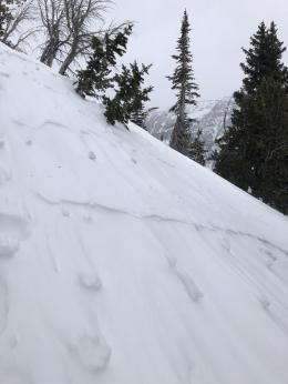
A foot of new snow (0.9-1.4” of snow water equivalent) since Saturday morning and strong winds added a big load to a weak snowpack. Across the southern ranges, the lower snowpack consists of 1.5’ of weak, sugary facets on the ground (photo). Over the last week, Doug and I found this poor structure on Lionhead Ridge (video), and Eric and Alex found it across the southern Madison Range (video, video, video).
Snowmobilers riding near Lionhead yesterday saw a natural avalanche and remotely triggered two other slides (details, photo). The slides broke 1-2’ deep and one was triggered by the 6th rider as they passed below a small, steep slope. These natural and human-triggered avalanches show that this weak snowpack has now been pushed to its breaking point. Avoid riding on steep slopes and also stay well out from under them, as you could trigger a slide from below. The avalanche danger today is CONSIDERABLE.
Almost a foot of new snow (0.8” snow water equivalent) has fallen in the mountains near Cooke City since Sunday morning. Strong winds from the southwest to northwest built thick slabs on wind loaded slopes where natural avalanches are possible and these fresh drifts of snow will be easy to trigger. There are also weak layers buried 1-2’ deep (video) and in areas where the new snow fell on a generally shallow, weak snowpack (video). Avalanches may break deeper, and wider, on these weak layers. Simply steer clear of steep, wind loaded slopes. Avalanches on these deeper weak layers are also possible on non-wind loaded slopes, dig down to look weak snow lower in the pack before committing to any steep slopes.
Today, avalanches are easy to trigger on wind loaded slopes and avalanche danger is CONSIDERABLE. On all other slopes, the avalanche danger is MODERATE.

While the couple inches of new snow and west winds yesterday formed some small, thin wind slabs, more deeply buried weak layers are our primary concern. Weak, sugary snow formed in early December and is now buried 1-2’ deep. We’ve received reports of avalanches or large collapses on these layers almost every day this past week (Activity log, photo, photo, photo). Yesterday, Alex went to investigate an avalanche triggered by a snowmobiler on Saturday, near Ross Peak. He found a 2’ thick hard slab resting over weak snow that remained reactive in stability tests (video).
Although it’s been a week since the last significant snowfall, don’t get lulled into complacency. Triggering an avalanche remains a distinct possibility today. Keep a watch for obvious signs of instability (cracking, collapsing, and recent avalanches), and cover your bases by taking the time to dig before committing to steep terrain. The avalanche danger today is MODERATE.
If you get out and have any avalanche or snowpack observations to share, contact us via our website, email (mtavalanche@gmail.com), phone (406-587-6984), or Instagram (#gnfacobs).
Avalanche Fatality in Colorado
On Saturday, a skier was killed in an avalanche during an avalanche safety course in southern Colorado. All six members of the group were caught in the avalanche. A preliminary report is available HERE.
Upcoming Avalanche Education and Events
Our education calendar is full of awareness lectures and field courses. Check it out: Events and Education Calendar.
BOZEMAN
TONIGHT!, 1/8, Women’s Specific Avalanche Awareness, 6:30-8 p.m. Story Mill Park, Bozeman.
January 9, 1-hr Avalanche Awareness, 7-8 p.m. Spire Climbing Center, Bozeman.
January 16, 17 and 19 or 20, Intro to Avalanches w/ Field Day, Info and Register Here.
January 23, 24 and 26, Advanced Avalanche Workshop w/ Field Day, Info and Register Here.
February 2, King and Queen of the Ridge at Bridger Bowl (fundraiser). Register with Bridger to hike in the event, and create a pledge page to raise funds with your Ridge laps.
WEST YELLOWSTONE
January 12 and 26, 1-hr Avalanche Awareness for Snowmobilers, 7-8 p.m. Holiday Inn West Yellowstone.
DILLON
January 22, 1-hr Avalanche Awareness, 6:30-7:30 p.m. U.M. Western Library.
BILLINGS
January 22, 1-hr Avalanche Awareness, 6-7 p.m. The Base Camp, Billings
COOKE CITY
Every Friday and Saturday, Rescue Training and Snowpack Update. Friday 6:30-7:30 p.m. at the Soda Butte Lodge. Saturday anytime between 10-2 @ Round Lake.
Read Doug’s recent article on Snowmobiler Education Efforts that will be published in the next issue of The Avalanche Review.