Good morning. This is Doug Chabot with the Gallatin National Forest Avalanche Forecast issued on Wednesday, January 9th at 7:15 a.m. Today’s forecast is sponsored by Swiss Fit Montana and Ph.D. Skis. This forecast does not apply to operating ski areas.
This morning there is no new snow to report. Mountain temperatures are in the high 20’s and above freezing (34F) in the Bridger Range from an inversion. Winds are blowing south to southwest at 10-20 mph with gusts of 40 mph. Today will start cloudy and slowly clear with winds remaining moderate from the southwest. Temperatures in the north may reach 40F and stay near freezing elsewhere. West Yellowstone can expect an inch of snow tonight.

The southern mountains, including the Lionhead area has a weak snowpack. This weekend’s storm was large enough to create widespread instability and avalanches. A 1.5 foot thick layer of sugary facets on the ground is breaking in our stability tests (photo), and more importantly, with human triggers. Snowmobilers triggered multiple avalanches on Sunday (details, photo) and again yesterday (photo, details), some from far away. Triggering slides is still likely given the overall weakness of the snowpack. Our field trips to Taylor Fork on Friday (video), Teepee Basin on Saturday (video), and Lionhead on Sunday (video), were all unanimous in finding poor stability. Avoid riding or skiing in steep terrain and beware of triggering slides from below. For today the avalanche danger is rated CONSIDERABLE on all slopes.

Eric and his partner are in Cooke City and found strong winds had scoured most terrain (photo). They found a mixed bag of conditions with the deeper, 4+ foot snowpack being strong compared with slopes that have 3 feet or less, which are weak. These shallower areas have sugary facets at the ground which will likely avalanche when heavy snowfall returns someday (it is Cooke City after all). The danger is dropping yet triggering avalanches is still possible because of this variability in the snowpack. The only way to know what is under your sled or skis is to dig. For today the avalanche danger is rated MODERATE on all slopes.
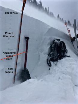
The mountains around Bozeman and Big Sky have not gotten significant snowfall in 10 days, yet people are still getting collapsing, cracking and triggering avalanches as recently as Sunday. An avalanche on Ross Peak, a small avalanche triggered in Beehive, and collapsing and cracking on Mt. Ellis are 3 of the most recent red flags. On Saturday, a snowmobiler triggered a 2 foot deep hard slab avalanche near Ross Peak that Alex investigated (details). The wind-loading was fierce, even as Alex was being filmed (video), and his video shows us the persistent weak layer we are faced with, a 1.5 foot thick layer of facets at the ground.
All the reported activity is on these facets which is not getting stronger anytime soon. Collapsing and cracking are evidence that our weight is initiating and propagating fractures on this layer and is bulls-eye information that the slope is unstable. There is no need to dig; cracking and collapsing are free stability tests. For today, avalanches are still possible and the danger is rated MODERATE.
If you get out and have any avalanche or snowpack observations to share, contact us via our website, email (mtavalanche@gmail.com), phone (406-587-6984), or Instagram (#gnfacobs).
Upcoming Avalanche Education and Events
Our education calendar is full of awareness lectures and field courses. Check it out: Events and Education Calendar.
BOZEMAN
TONIGHT! January 9, 1-hr Avalanche Awareness, 7-8 p.m. Spire Climbing Center, Bozeman.
January 16, 17 and 19 or 20, Intro to Avalanches w/ Field Day, Info and Register Here.
January 23, 24 and 26, Advanced Avalanche Workshop w/ Field Day, Info and Register Here.
February 2, King and Queen of the Ridge at Bridger Bowl (fundraiser). Register with Bridger to hike in the event, and create a pledge page to raise funds with your Ridge laps.
WEST YELLOWSTONE
January 12 and 26, 1-hr Avalanche Awareness for Snowmobilers, 7-8 p.m. Holiday Inn West Yellowstone.
DILLON
January 22, 1-hr Avalanche Awareness, 6:30-7:30 p.m. U.M. Western Library.
BILLINGS
January 22, 1-hr Avalanche Awareness, 6-7 p.m. The Base Camp, Billings
COOKE CITY
Every Friday and Saturday, Rescue Training and Snowpack Update. Friday 6:30-7:30 p.m. at the Soda Butte Lodge. Saturday anytime between 10-2 @ Round Lake.
Ian Hoyer just joined the GNFAC as a forecaster. We interview Ian in Dashboard Talks: Episode 1.