Good morning. This is Doug Chabot with the Gallatin National Forest Avalanche Forecast issued on Thursday, January 10th at 7:00 a.m. Today’s forecast is sponsored by Grizzly Outfitters in partnership with the Friends of the Avalanche Center. This forecast does not apply to operating ski areas.
All USFS avalanche centers are “excepted” to the government shutdown and operating as normal.
Last night a trace to an inch of snow fell in the Lionhead area. This morning mountain temperatures are in the low 20s F with south to southwest wind blowing 15-20 mph with gusts of 40 mph. Clouds in the southern mountains will clear this afternoon as high pressure brings sunny skies and above normal temperatures for the next 7 days. Today, temperatures will rise into the mid-30s F and winds will shift westerly to 10-20 mph.

The mountains south of Big Sky to West Yellowstone have a weak and unstable snowpack. It is weak because sugary facets making up the lower half of the snowpack are unsupportable (photo, video). A person will sink to the ground when they step off their snowmobile or skis. The snowpack is unstable because there is enough weight from new and windblown snow to create natural avalanches, cracking and collapsing. Yesterday morning a large natural avalanche released on the heavily wind-drifted Lionhead Ridge (details), and skiers in Taylor Fork got a large collapse with shooting cracks on a wind-loaded slope (photo, details). This is the fourth day in a row of avalanche activity. Today, wind-loaded slopes have a CONSIDERABLE avalanche danger and should be avoided. All other slopes have a MODERATE danger.

Whenever we go in the field we always have a question that needs to be answered. Yesterday I wanted to know if the shallowest and weakest snow in the northern areas is getting stronger, so my partners and I toured on Mt. Ellis. The snowpack was only 2-3 feet deep with the bottom two-third consisting of unsupportable facets. We did not get any collapsing or cracking on open slopes and our 2 snowpits showed improving stability (video). In the absence of new snow or wind-loading the snowpack is getting stronger.
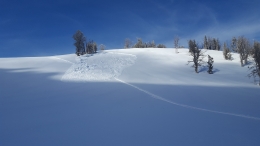
The avalanche near Ross Peak in the Bridger Range on Saturday is still relevant as an example of our current avalanche concern (details). A hard slab of windblown snow sitting on a foot or more of weak facets could be triggered. The northern ranges and also the mountains around Cooke City have this recipe on some slopes. Eric was in Cooke City the last 2 days and found most slopes wind-scoured and only a few wind-loaded (photo). If wind drifts are not sitting on facets, they won’t avalanche. He found a mixed bag of conditions which he outlines in his video. In essence, snowpacks less than 3 feet deep are weak and could avalanche with a wind-load, while snowpacks that are deeper lack well-developed facets and are stronger (photo). Dig, probe and be wary of slopes that are shallow and faceted. Today the avalanche danger is rated MODERATE.
If you get out and have any avalanche or snowpack observations to share, contact us via our website, email (mtavalanche@gmail.com), phone (406-587-6984), or Instagram (#gnfacobs).
Upcoming Avalanche Education and Events
Our education calendar is full of awareness lectures and field courses. Check it out: Events and Education Calendar.
BOZEMAN
January 16, 17 and 19 or 20, Intro to Avalanches w/ Field Day, Info and Register Here.
January 23, 24 and 26, Advanced Avalanche Workshop w/ Field Day, Info and Register Here.
February 2, King and Queen of the Ridge at Bridger Bowl (fundraiser). Register with Bridger to hike in the event, and create a pledge page to raise funds with your Ridge laps.
WEST YELLOWSTONE
January 12 and 26, 1-hr Avalanche Awareness for Snowmobilers, 7-8 p.m. Holiday Inn West Yellowstone.
DILLON
January 22, 1-hr Avalanche Awareness, 6:30-7:30 p.m. U.M. Western Library.
BILLINGS
January 22, 1-hr Avalanche Awareness, 6-7 p.m. The Base Camp, Billings.
COOKE CITY
Every Friday and Saturday, Rescue Training and Snowpack Update. Friday 6:30-7:30 p.m. at the Soda Butte Lodge. Saturday anytime between 10-2 @ Round Lake.
Ian Hoyer just joined the GNFAC as a forecaster. We interview Ian in Dashboard Talks: Episode 1.