Good morning. This is Eric Knoff with the Gallatin National Forest Avalanche Forecast issued on Friday, January 11th at 7:00 a.m. Today’s forecast is sponsored by Werner Wealth Management and Gallatin County Search and Rescue. This forecast does not apply to operating ski areas.
Yesterday afternoon, light snow showers dropped a trace to 1” of snow in the mountains around Big Sky. The rest of the forecast area remained dry. At 5 a.m. temps range from the teens to low 20’s F under mostly clear skies. Westerly winds are blowing 5-15 mph with gusts in the Bridger Range breaking 20 mph. Today, temps warm into the upper 20’s to low 30’s F and winds remain light to moderate out of the west. There’s no snow in the forecast as far as the eye can see.

Despite the absence of new snow and wind, obvious signs of instability continue to take place in the southern Madison Range and mountains near West Yellowstone. Here is a short list of activity in the southern ranges.
- Cracking and collapsing, Taylor Fork southern Madison Range (photo) 1/9
- Natural avalanche, Lionhead area near West Yellowstone 1/9
- Natural avalanches, Taylor Fork southern Madison Range (photo) 1/9
- Remotely triggered avalanches, Hellroaring Creek Centennial Range (photo) 1/8
- Snowmobile triggered avalanche, Lionhead area near West Yellowstone 1/8
- Cracking and collapsing, Specimen Creek southern Gallatin Range 1/8
- View a more comprehensive list of activity here.
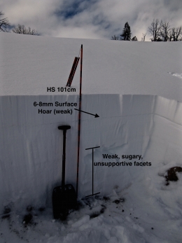
The culprit of such an active snowpack is weak, faceted snow near the ground. This persistent weak layer is widespread and showing little sign of gaining strength (video). Yesterday, Alex and his partner rode in Cabin Creek in the southern Madison Range a found a weak and unsupportable snowpack (video). Slopes that received wind deposited snow earlier in the week will be most prone to producing avalanches, but non-wind loaded slopes also need to be approached with caution.
The simple strategy to staying safe is avoid all steep slopes. This also means avoiding low angle terrain attached to steeper slopes above. Warmer temperatures will gradually improve stability, but recent avalanche activity is a clear reminder the pack needs more time to gain strength.
Today, human triggered avalanches are likely on wind loaded slopes which have a CONSIDERABLE avalanche danger. Non-wind loaded slopes have a MODERATE avalanche danger.

Snowpack stability is better in the mountains around Bozeman, Big Sky and Cooke City, but a recent slide up Portal Creek in the northern Gallatin Range is a clear reminder these areas are not immune to avalanches (photo). Slopes that have wind drifted snow resting over weak facets near the ground are the most likely to produce unstable conditions. Yesterday, skiers near Naya Nuki in the northern Bridgers got unstable test results on a wind loaded slope with facets near the ground. The avalanche near Ross Peak last Saturday is a relevant example of this problem (details). Not all wind loaded slopes have a poor snowpack structure, so it’s important to assess each slope carefully.
Non-wind loaded slopes are more stable, but still hold the potential to produce slides. On slopes where the snowpack is shallow (less than 3’ deep), you’ll likely find a weak, faceted snowpack (video, video). The best way to determine if these slopes are unstable is watch for signs of instability such as cracking/collapsing or dig and do a stability test. If you experience whumphing and cracking or get unstable test results, steer clear of avalanche terrain.
An additional problem today will be loose wet avalanches on steep, sun exposed slopes. Watch for roller balls or small point releases and move to shadier aspects if these signs are present.
Stability is improving, but human triggered avalanches remain possible and the avalanche danger is rated MODERATE.
Avalanche Fatality, Togwotee Pass Wyoming
On Wednesday, a snowmobiler was killed in an avalanche on Togwotee Pass northeast of Jackson Hole. Preliminary details from the Bridger Teton Avalanche Center can be found here. The BTAC will have an updated accident report in the near future. This is the third U.S. avalanche fatality in the past week. Our condolences go out to the friends and family of the victim.
Upcoming Avalanche Education and Events
Our education calendar is full of awareness lectures and field courses. Check it out: Events and Education Calendar.
BOZEMAN
January 16, 17 and 19 or 20, Intro to Avalanches w/ Field Day, Info and Register Here.
January 23, 24 and 26, Advanced Avalanche Workshop w/ Field Day, Info and Register Here.
February 2, King and Queen of the Ridge at Bridger Bowl (fundraiser). Register with Bridger to hike in the event, and create a pledge page to raise funds with your Ridge laps.
WEST YELLOWSTONE
January 12 and 26, 1-hr Avalanche Awareness for Snowmobilers, 7-8 p.m. Holiday Inn West Yellowstone.
DILLON
January 22, 1-hr Avalanche Awareness, 6:30-7:30 p.m. U.M. Western Library.
BILLINGS
January 22, 1-hr Avalanche Awareness, 6-7 p.m. The Base Camp, Billings.
COOKE CITY
Every Friday and Saturday, Rescue Training and Snowpack Update. Friday 6:30-7:30 p.m. at the Soda Butte Lodge. Saturday anytime between 10-2 @ Round Lake.
Ian Hoyer just joined the GNFAC as a forecaster. We interview Ian in Dashboard Talks: Episode 1.