Good morning. This is Doug Chabot with the Gallatin National Forest Avalanche Forecast issued on Thursday, February 28th at 7:00 a.m. Today’s forecast is sponsored by Map Brewing and Swiss Fit Montana. This forecast does not apply to operating ski areas.
AVALANCHE WARNING
The Gallatin National Forest Avalanche Center is continuing a Backcountry Avalanche Warning for the Southern Gallatin and Southern Madison Ranges, the Lionhead area near West Yellowstone, the Centennial Range, and the mountains around Cooke City. Heavy snowfall and strong wind are creating very dangerous avalanche conditions. Natural and human triggered avalanches are likely. Avalanche terrain and avalanche runout zones should be avoided. The avalanche danger is rated HIGH on all slopes.
AVALANCHE FATALITY
On Tuesday, a solo skier was killed in a slide on the west side of the Bridger Range at the top of Truman Gulch. He triggered the avalanche on a steep, wind-loaded slope that broke 3 feet deep, 150 feet wide and carried him 1,000 feet to the toe of the debris where he was buried. Two other skiers witnessed the slide and responded quickly. While doing a beacon search they saw his hand sticking out of the snow. They dug him up and did CPR, but the skier was not revived. In the next 24 hours we will release an accident report. Preliminary information and photos are located here.
The snowfall continues unabated. Since yesterday morning the southern mountains, including Cooke City, received 8-10” of new snow while Big Sky and the Bridger Range got 6-7”, and 3” falling up Hyalite. Mountain temperatures are in the 20s and winds are west to southwest at 10-20 mph with gusts reaching 40 mph. Snowfall will continue today and by tomorrow morning I expect 2-4” in the north and 4-8” in the southern ranges. Winds will continue to be westerly at 20-30 mph and temperatures will remain in the 20s.

Avalanche Warning
The Avalanche Warning continues in the southern ranges. Snowfall has not let up and in the last 24 hours another 8-10” fell totaling another inch of snow water equivalent (SWE). Since the start of the storm early Sunday morning close to 6.5” of SWE has fallen around West Yellowstone, 4.5” in Taylor Fork and 5” outside Cooke City. Steady snowfall is adding more weight every day and slopes are avalanching. The likelihood of very large avalanches breaking near the ground is increasing. Do not trust any slope steeper than 30 degrees (avalanche terrain). Do not travel underneath avalanche terrain. Do not venture into the backcountry if you have poor visibility or do not know the terrain intimately. Skiers and riders die when they mistakenly think they are not exposed to avalanche terrain. Eric and I skied into Bacon Rind on Tuesday and found unstable conditions: a large whumph and poor stability test scores (video). Human triggered avalanches are very likely today and the danger is rated HIGH on all slopes.

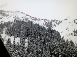
Snowfall and heavy wind-loading from south and east winds has created dangerous avalanche conditions in the northern mountains. A skier died on the west side of the Bridger Range on Tuesday when he triggered a hard slab avalanche on a wind-loaded slope. It was the second time this season the slope avalanched. Yesterday, skiers in the northern Bridger Range found many crowns and debris piles (details), and skiers intentionally avalanched a small wind-drifted slope in the northern Madison Range with a ski cut (photos and details).
The water weight in the north adds up to 1.7-2.9” of SWE with more coming today. Although wind-loaded slopes are the likeliest areas to trigger a slide, slopes without wind drifts are getting loaded to a dangerous level as well. For this reason the avalanche danger is rated CONSIDERABLE on all slopes.
If you get out and have any avalanche or snowpack observations to share, contact us via our website, email (mtavalanche@gmail.com), phone (406-587-6984), or Instagram (#gnfacobs).
Upcoming Avalanche Education and Events
Our education calendar is full of awareness lectures and field courses. Check it out: Events and Education Calendar.
BOZEMAN
March 1, 2 and 3, Bozeman Split Fest, More info at www.bozemansplitfest.com.
March 6, 1-hr Avalanche Awareness, 6-7 p.m. at REI Bozeman.
ENNIS
February 28 and March 3, Intro to Avalanches w/ Field Day, More Info and Register Here.
COOKE CITY
Every Friday and Saturday, Rescue Training and Snowpack Update. Friday 6:30-7:30 p.m. at the Soda Butte Lodge. Saturday anytime between 10-2 @ Round Lake.
Seventeen people have died in avalanches across the U.S this winter (‘18/’19). Take a few minutes to read this season’s avalanche fatality reports. These reports provide a great opportunity to learn from these tragic accidents.