Good morning. This is Alex Marienthal with the Gallatin National Forest Avalanche Forecast issued on Monday, March 18th at 7:00 a.m. Today's forecast is sponsored by Gallatin County Search and Rescue and Montana State Parks. This forecast does not apply to operating ski areas.
This morning temperatures are teens to mid-20s F under clear skies. There is no new snow. Wind is northerly at 5-15 mph, and near Cooke City wind is out of the east. Today temperatures will reach the mid to high 30s F under clear skies. Wind will be northwest to northeast at 5-15 mph. Expect similar clear and dry weather through tomorrow and warmer temperatures later in the week.

All Regions
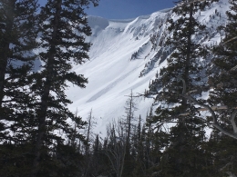
Today the snowpack is generally stable and avalanches are unlikely. This morning sunny slopes have a stable, frozen crust on the surface. I expect this crust will soften slowly and wet loose avalanches will be minimal. Over the weekend temperatures reached the mid to upper 30s F, and relatively few small loose snow avalanches were observed (photo, photo, photos). Similar weather today will create similar, generally stable conditions.
If you travel into steep terrain, remain cautious and be on the lookout for isolated instabilities. Small wet loose avalanches are possible near steep, sunny rock outcrops. Yesterday Ian saw small loose snow slides near Cooke City (video, photo), and on Saturday I saw a few in the northern Bridgers (video). Move to shadier slopes or lower angle terrain if the snow surface becomes moist, or if you see roller balls or natural point release slides.
On shady slopes the snow has stayed dry. Northerly winds could drift this snow into small fresh slabs. Look out for these wind slabs if you see blowing snow along ridgelines. Small slides can be dangerous if they knock you down or carry you through trees or over cliffs.
On Friday near Big Sky a small wind slab was likely triggered by a cornice fall (photo). Cornices are large and can break naturally during warm, sunny days. Minimize or avoid travel on slopes below cornices. On Saturday near Virginia City (outside our advisory area) snowmobilers triggered a large slab avalanche (photo). These isolated events are reminders to remain diligent about snowpack and terrain assessment (video). Yesterday skiers in Hyalite found multiple unstable tests scores on a weak layer buried one foot deep, and happily changed their objective to more conservative terrain.
Today the snowpack is generally stable and avalanche danger is rated LOW. If you travel in steep terrain, carefully assess the snowpack and terrain for possible isolated instabilities.
If you get out and have any avalanche or snowpack observations to share, contact us via our website, email (mtavalanche@gmail.com), phone (406-587-6984), or Instagram (#gnfacobs).
Upcoming Avalanche Education and Events
Spring is here and wet snow avalanches are becoming a daily concern. Anticipate decreasing stability while forming a travel plan. This article from Backcountry Magazine highlights some things look for that indicate when it is time to turn around.