Good Morning. This is Alex Marienthal with the Gallatin National Forest Avalanche Forecast on Monday, January 27th at 7:00 a.m. Today’s forecast is sponsored by Your Montana Chevy Dealers and Ph.D. Skis. This forecast does not apply to operating ski areas.
Last night snow totaled 5” in the Bridger Range, 3-4” near West Yellowstone and Cooke City, and 2” in Big Sky and Hyalite. This morning wind is westerly at 5-10 mph with gusts of 15-25 mph. Temperatures are high teens to high 20s F. Today temperatures will be 20s to low 30s F with west-northwest wind at 15-25 mph. Snow tapers off this morning with light showers possible today and more snow expected late Tuesday.

All Regions
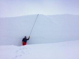
Today’s 3-5” of new snow (0.3-0.4” snow water equivalent) does not increase avalanche danger, but creates some additional hazard. Fresh drifts of snow are possible to trigger. These drifts are larger where more snow fell, and will grow today with moderate wind. Be cautious of wind loaded slopes near ridgelines, identifiable by rounded pillows of snow or overhanging cornices (photo). Cracking of the snow surface around your feet is a sign fresh drifts are unstable and to avoid steep wind loaded slopes. Even a small slide can be deadly in the wrong terrain, and could be a trigger for a larger avalanche.
A less likely, but larger avalanche is possible to trigger breaking at least 2-4 feet deep on sugary weak snow near the base of the snowpack. I wrote this mid-season snowpack summary to review the poor snowpack structure and recent large avalanches. It is more difficult to trigger one of these large avalanches than it was a week ago, but the consequences are large. Conservative decision making and cautious route finding are advised.
There are fewer warning signs like collapses that tell us the weak, sugary snow is buried deep below our feet, but red flags are not entirely absent. We know a poor snowpack structure exists on many slopes. We continue to get unstable extended column test results (snowpit profile). On Thursday a skier had a big collapse north of Bridger (details), and on Friday Big Sky ski patrol triggered a large slide on weak snow near the ground (details and photos). Several large skier and snowmobiler triggered avalanches last weekend are a reminder of what is possible (photos).
Avoid heavily wind loaded slopes, where large slides can be triggered from thinner areas of the snowpack (video). Some slopes have a shallower, sugary weak snowpack where avalanches can break wide though maybe not as deep. These might not be as large as the deep hard slabs, but are easier to trigger and still deadly. Friday on Mt. Ellis I found the shallowest weakest snowpack in our area which will become unstable with a few more inches of snow (video). Yesterday Doug and I found a similar structure on one of the shallower slopes in Taylor Fork (snowpit profile).
Today avalanches are possible to trigger and avalanche danger is MODERATE. Carefully assess snowpack and terrain before riding on or underneath steep slopes.
If you get out, please send us your observations no matter how brief. You can fill out an observation form, email us (mtavalanche@gmail.com), leave a VM at 406-587-6984, or Instagram (#gnfacobs).
King and Queen of the Ridge at Bridger Bowl
Next Saturday, February 1, is the King and Queen of the Ridge at Bridger Bowl! Come up and help us raise money by hiking and skiing laps on the ridge. Prizes, camaraderie and a good time are guaranteed. Register with Bridger to hike in the event and create a pledge page to raise funds with your Ridge laps.
Upcoming Avalanche Education and Events
Our education calendar is full of awareness lectures and field courses. Check it out and plan to attend one or two: Events and Education Calendar.
COOKE CITY
Every Friday and Saturday, Snowpack Update and Rescue Training. Friday, 6:30-7:30 p.m. at the Soda Butte Lodge. Saturday anytime between 10-2 @ Round Lake.
BOZEMAN
TODAY!, Avalanche Information and Demonstration Table, 10 a.m. to 12 p.m. at Montana Science Center.
January 29, GNFAC Forecaster Chat: Avalanche Myth Busters, 6-8 p.m. at Uphill Pursuits.
January 31, Women’s Only Companion Rescue Clinic, 6 - 8 pm at REI followed by a field day February 1. More info and Register Here.
February 1, King and Queen of the Ridge at Bridger Bowl (fundraiser). This is the Friends of the Avalanche Center’s second biggest fundraiser of the year. Help us raise money by hiking and skiing laps on the ridge. Prizes, camaraderie and a good time is guaranteed. Register with Bridger to hike in the event, and create a pledge page to raise funds with your Ridge laps.
DILLON
January 29 and 30, Introduction to Avalanche w/ Field Course, evenings of January 29 & 30 plus a field day February 1. Snowmobile specific field day offered February 2. More Info and Register Here.
WEST YELLOWSTONE
February 1, 1-hr Avalanche Awareness, 7-8 p.m. at West Yellowstone Holiday Inn.
HELENA
January 28, 1-hr Avalanche Awareness, 6-7 p.m. Carroll College.
LIVINGSTON
January 30, Introduction to Avalanche w/ Field Course, evening of January 30 plus a field day February 2. More info and Register Here.
See our mid-season snowpack summary for a review of the deep slab avalanche problem and general (conservative) travel advice.