Good Morning. This is Alex Marienthal with a spring weather and snowpack update on Monday, April 20th. The Gallatin National Forest Avalanche Center has stopped issuing daily avalanche forecasts for the season. We will issue weather and snowpack updates on Monday and Friday mornings through April.
Yesterday the mountains got a trace of snow with light rain at lower elevations. Over the weekend temperatures reached mid-40s F with lows in the 20s F. This morning temperatures are mid-20s to low 30s F with west-northwest wind at 15-30 mph. Today through Wednesday will be mostly sunny with temperatures reaching mid-40s to 50 F and overnight temperatures in the high 20s to low 30s F. Wind will be west-northwest at 10-20 mph. On Wednesday wind will increase to 20-30 mph with a chance for snow and rain Wednesday night through Thursday.

All Regions
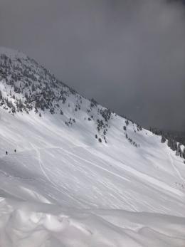
Wet snow avalanche danger will rise this week. The snowpack is frozen and stable this morning, and will become wet and lose strength as above freezing temperatures and sun melt the snow. Expect a similar trend the next couple days with temperatures near freezing each night and daytime highs up to 50 F. Wet loose avalanches similar to those observed over the weekend will be easy to trigger and run naturally (photo, photo). Large destructive wet slabs are possible the next couple days as meltwater seeps deeper into the snowpack.
The warmest temperatures of the year the next couple days with only brief freezing temperatures each night means the snowpack will get wet and lose strength earlier each day. Plan to start early and avoid being on or underneath steep slopes before the snow becomes wet and unsupportive (photo). Carefully assess and re-assess snow stability through the day. A wet snow surface or a thin, unsupportive crust with wet snow below indicate poor stability. Anticipate stability to vary greatly between different aspects, elevations and times of day.
Read this season’s snowpack summary for a review of the poor snowpack structure that could still produce big wet slabs. See below for additional general spring snowpack and travel advice.
Please continue to send us your observations. You can fill out an observation form, email us (mtavalanche@gmail.com), leave a VM at 406-587-6984, or Instagram (#gnfacobs). We greatly appreciate your support.
Give Big Gallatin Valley
Give Big Gallatin Valley is April 30th - May 1st. The Friends of the Avalanche Center are participating again this year and want to thank all of you for your support.
Closures and Stay-At-Home Order
A Stay at Home order is in effect for the State of Montana due to COVID-19. This order specifically discourages “outdoor recreation activities that pose enhanced risks of injury or could otherwise stress the ability of local first responders to address the COVID-19 emergency (e.g., backcountry skiing in a manner inconsistent with avalanche recommendations or in closed terrain)”.
Bridger Bowl is closed and advises against uphill travel which could place first responders at risk. Backcountry conditions exist. There is no avalanche control or ski patrol rescue. Please do not loiter or congregate in the parking lots.
Park County is requesting anyone who is not a permanent resident or provider of essential service to avoid travel to Cooke City/ Silvergate. This includes both single day and overnight visitors.
Hyalite Canyon is closed to vehicle traffic and will reopen on May 16th. This is the regular spring use closure.
GENERAL SPRING SNOWPACK AND TRAVEL ADVICE
Spring weather can be highly variable and create a mix of avalanche problems to watch out for. Snow conditions and stability can change drastically from day to day or hour to hour. Anticipate rapid change and plan accordingly. Abundant snowfall over the winter with more spring snow to come makes avalanches possible into summer.
NEW SNOW AND WIND LOADED SLOPES
Spring storms are notorious for depositing heavy amounts of snow in the mountains. Even with a deep and generally stable snowpack throughout the advisory area, heavy and rapid loads of new snow will decrease stability. The main problems to look out for are avalanches breaking within the new snow, wind slabs, and loose snow avalanches. The likelihood of triggering an avalanche spikes during and immediately after snowstorms. New snow instabilities tend to stabilize quickly, but it’s a good idea to give new snow a day to adjust before hitting big terrain. New snow instabilities can be difficult to assess, and spring storms bond to old snow differently across aspects and elevations. Conservative terrain selection is essential during and immediately following storms. Wind loaded slopes and slopes steeper than 35 degrees should be avoided for 24-48 hours after new snow and wind.
New snow can quickly change from dry to wet on a spring day, and stability can decrease rapidly with above freezing temperatures or brief sunshine. New snow may bond well early in the morning, and then easily slide later. Wet loose slides are likely during the first above freezing temperatures or sunshine immediately after a storm. Anticipate changes in snow stability as you change aspect or elevation, and over the course of the day. An early start is always an advantage. Be ready to change plans or move to safer terrain at the first signs of decreasing stability.
WET SNOW AVALANCHES
Spring and wet snow avalanches go hand-in-hand. Above freezing temperatures, rain, and/or intense sunshine cause the snow to become wet and weak, and make wet avalanches easy to trigger or release naturally. Conditions tend to become most unstable when temperatures stay above freezing for multiple days and nights in a row. Avoid steep terrain, and be aware of potential for natural wet avalanches in steep terrain above you, if you see:
- Heavy rain,
- Above freezing temperatures for more than 24 hours,
- Natural wet avalanches,
- Roller balls or pin wheels indicating a moist or wet snow surface,
- Or if you sink to your boot top in wet snow.
In general, if the snow surface freezes solid overnight, the snowpack will be stable in the morning and stability will decrease through the day as snow warms up. The snow surface hardness, rate of warming, duration of sunshine, aspect and elevation determine how fast stability will decrease through the day. Be aware that sunny aspects may have a wet snow avalanche danger while shadier slopes still have a dry snow avalanche danger. Getting off of steep slopes should be considered when, or before, the above signs of instability are present. Wet snow avalanches, whether loose snow or slabs, can be powerful, destructive and very dangerous. Conservative terrain choices, starting early in the day, and careful observations can keep you safe. See Alex’s recent video, and this article for more spring travel advice.
CORNICES
Cornices along ridgelines are massive and can break under the weight of a person (photo). Prolonged above freezing temperatures and rain make them weaker and possible to break naturally. They can break off suddenly and farther back than one might expect. Cornice falls can also entrain large amounts of loose snow or trigger slab avalanches. Stay far back from the edge of ridgelines and minimize exposure to slopes directly below cornices. Regardless of whether a cornice triggers a slide or not, a falling cornice is dangerous to anyone in its path.
DISCLAIMER
It does not matter if new snow falls or not, avalanches will continue to occur until the existing snowpack is mostly gone. Always assess the slope you plan to ride with diligence and safety in mind. Do not let your guard down. Travel with a partner, carry rescue gear and only expose one person at a time in avalanche terrain.
Have a safe and enjoyable spring and summer!
Doug, Alex, Ian and Dave
For more spring travel advice see this article from our GNFAC forecaster blog.
Touring at Bridger Bowl? The ski area has been closed with no avalanche mitigation work for a month. Familiar routes may not be advisable. For example, the North Bowl Road crosses through the middle of serious avalanche terrain that is controlled during the season. It is not a good route for your skin track (photo).