|
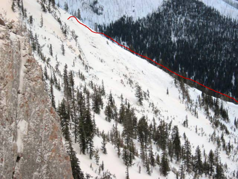
Bridger Range, 2012-03-18 This avalanche happened last night (Sat, 3/17). Starting point in upper left of red line which denotes the crown. It broke at the ground. Photo: L. Watson
|
|
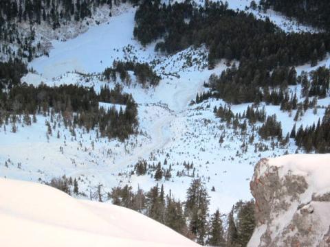
Bridger Range, 2012-03-18 The debris ran almost full track. It measures over 1,000 feet vertical. Photo: L. Watson
|
|
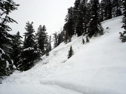
Lionhead Range, 2012-03-18 This slide occurred on the trail leading to Two Top outside of West Yellowstone. Over two feet of heavy snow has fallen in this area over the past week producing widespread natural and human triggered avalanches. Photo Jim Norlander
|
|
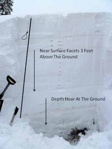
Lionhead Range, 2012-03-17 Two distinct weak layers exist in the snowpack near Lionhead. Both layers are fully capable of producing avalanches. Photo GNFAC
|

|
Lionhead Range, 2012-03-17 Many natural slides were visible from the Lionhead Ridge. Over two feet of heavy, dense snow has fallen in this area over the past week. Facets buried near the ground and 2-3 feet above the ground are failing due to this load. Slides that are occurring on these layers are breaking deep and propagating long distances. Photo GNFAC
|

|
Lionhead Range, 2012-03-17 New snow and strong southwest winds have loaded leeward slopes, pushing many past their breaking point. This slide occurred off Lionhead Ridge and broke on a layer of facets about 60 cm above the ground. The crown was 3-8 feet deep and propagated 400 feet wide. This slide likely happened on 3-16-12. Photo GNFAC
|

|
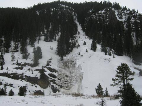
Southern Gallatin, 2012-03-17 This wet slab released along Hwy. 191 at about 7200ft. Photo: W. Shoutis
|
|
Southern Gallatin, 2012-03-17 This wet snow avalanche occurred along Hwy. 191 at about 7200ft. Photo: W. Shoutis
|

|
Lionhead Range, 2012-03-16 This hard slab avalanche occurred on 2 p.m. on Friday, March 16th. It slid on an E facing slope on the way to Lionhead at approximately 8000ft. Photo: C. Aasness
|

|
Bridger Range, 2012-03-16 This natural occurred on the north side of Hardscrabble Peak in the northern Bridgers. The slide was likely triggered by a cornice drop. Photo GNFAC
|

|
Bridger Range, 2012-03-16 Strong southwest winds on Tuesday March 12th, heavily loaded north and east facing slopes in the Bridger Range. This slide is likely the result of that wind event. The slide appears to have initiated in the steep rocks directely below the ridge, but pulled out the entier seasons snowpack lower on the slope. Depth hoar near the ground exists on many slopes in the Bridger Range and contiues to demonstrate its ability to propagate fractures with the proper trigger. This slide occurred on the north side of Hardscrabble Peak. Photo GNFAC
|

|
Bridger Range, 2012-03-15 Strong south/southwest winds heavily loaded east and north facing slopes in the Bridger Range on Tuesday (3-13-12). This slide occurred naturally in the Y Coulior on the west side of Saddle Peak either Tuesday night or Wednesday morning. Photo GNFAC
|

|
Bridger Range, 2012-03-15 The Bridger Bowl Ski Patrol triggered multiple multiple slide during control work today (3-15-12). Most were triggered below the ridgelines in steep, rocky terrain. Strong south/soutwest winds loaded east and north facing slopes over the past few days. Fresh drifts are resting over weak and in some places isothermal facets, which are providing a weak foundation for any type of load. Photo GNFAC
|

|
Lionhead Range, 2012-03-15 This pit was dug on a north facing slope at Lionhead. The ECT failed on 29 taps on large depth hoar crystas less than a foot off the ground. Although it would be difficult to trigger when it is this far under the surface, in areas wher the snowpack is thinner a snowmobiler could initiate a fracture that would propagate to deeper slopes like this one. Photo: GNFAC
|

|
Cooke City, 2012-03-15 During Wednesday's (3/14) snow, graupel fell in many areas. Graupel is little balls of snow, and it typically rolls downhill and accumulates on aprons under ridges and cliff bands. Once covered by regular snow, graupel can produce avalanches. Luckily this is a relatively short lived problem. Photo: B. Fredlund.
|

|
Southern Madison, 2012-03-15 Ace Powder Guides found a weak layer 3.5 feet deep in Teepee Basin of the southern Madison Range yesterday. Stability test results kept them from climbing anything steep and only riding low angle slopes. Photo: B. Radecky
|

|
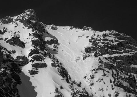
Bridger Range, 2012-03-14 The Y couloir on the west side of Saddle Peak area avalanched naturally. Ski Patrol took this picture from the ridge this morning. Strong south winds loaded this slope with a hard slab. Red circle indicates crown line. Photo: P. Maleski
|
|
Northern Madison, 2012-03-13 This avalanche on the east face of Blaze Mountain (10,602') in the N. Madison Range was likely triggered by a cornice breaking. It likely occurred on Friday or Saturday. Photo: A. Whitmore
|

|
Bridger Range, 2012-03-13 We dug this snowpit on an east facing slope at 8200 fet in the Bridger Range. The depth hoar at the ground was quite large and took a lot of force to break, but is still a concern and likely will be for the rest of the season. Photo: GNFAC
|

|
, 2012-03-12
|