Photos

|
Southern Madison, 2025-03-16 On March 15 We looked at the avalanche in Sunlight Basin/Taylor Fork that was triggered by a snowmobiler yesterday (Mar 14). It was 50' wide, 100' vertical, 2-3' deep hard slab with 8-9" new snow on top. Broke on weak facets buried in late January. Dirt layer from Feb 4 was visible 6-8" above weak layer. Bed surface was 3" to 1.5' deep of weak, sugary facets. Slope angle was 38-40+ degrees. 8800', WNW aspect. Photo: GNFAC Link to Avalanche Details |

|
Bridger Range, 2025-03-15 Mar 15 Winds in the Frazier Basin zone were stronger than expected with moderate to strong gusts at the ridge, increasing through the day. We noticed two large windslab pockets that had released since yesterday’s snow. One at the base of Hardscrabble Peak on a N aspect, the other in one of the SE facing gullies that access the Peak 9299/Hollywood Headwall ridge (see photo). Link to Avalanche Details |

|
Island Park, 2025-03-15 Stability tests continually fractured on old, broken snowflakes just under a crust under the new snow about 16" deep |

|
Island Park, 2025-03-15 Small natural storm slab Link to Avalanche Details |

|
Island Park, 2025-03-15 This avalanche started on a slope above the rocks where there was more wind and then triggered another storm slab in the trees. It created a significant debris pile. Link to Avalanche Details |

|
Island Park, 2025-03-15 Light red lines indicate crown faces of this natural avalanche. It likely started as a wind slab/storm slab above the rocks, then dropped down onto the slope below triggering a storm slab avalanche that entrained a significant amount of snow and created a big debris pile. Link to Avalanche Details |

|
Southern Madison, 2025-03-15 On Mar 14 A group of riders shared that they had triggered a 4' deep slide in a small pocket in Sunlight Basin of the Taylor Fork area. It was in an area with a relatively shallower snowpack, and broke on weak snow near the bottom of the snowpack. The rider that triggered it was going uphill and got stuck shortly after and noted the snowpack was much deeper there. Link to Avalanche Details |

|
Cooke City, 2025-03-14 Near Cooke City on Mar 14 there was 6" of new snow and wind was calm, even along the ridge near regularly wind-loaded slopes, and there was no snow blowing off ridgelines. The photo shows a slope that normally receives a lot of wind effect, but the new snow is unaffected indicating the wind has been calm. Photo: GNFAC |

|
Cooke City, 2025-03-14 Dug a pit on a northeast facing slope, 9300' (profile and pic attached) near Cooke City. Snow depth was 7-8 feet. 6" of new snow was right side up. Below the new snow was a soft (1F-) melt-freeze crust with soft decomposing and slightly faceted particles below. ECTN13 broke below the crust. Below that the snowpack was 1F to P+ hard and lacked weak layers. The Feb 4 dirt layer was clearly visible. Photo: GNFAC |

|
Cooke City, 2025-03-14 Today I observed multiple small wind slab avalanches off Woody Ridge. NE and E facing, 10000 ft. Max size D1. Photo: BPG Link to Avalanche Details |

|
Cooke City, 2025-03-14 Today I observed multiple small wind slab avalanches off Woody Ridge. NE and E facing, 10000 ft. Max size D1. Photo: BPG Link to Avalanche Details |

|
Cooke City, 2025-03-14 Many dry loose slides on Cooke Peak in Hayden Creek. Photo: BPG |
|
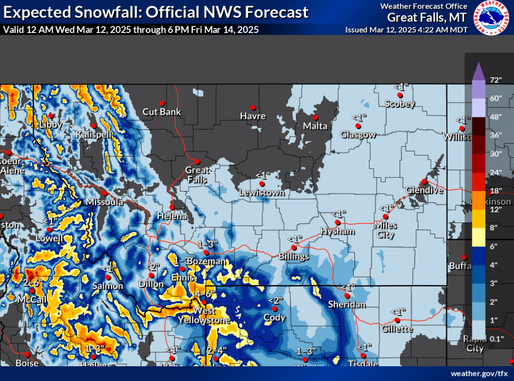
, 2025-03-12 Snowfall forecast through Friday evening, March 14 |

|
Bridger Range, 2025-03-11 Mountain goat hanging out in Wolverine Bowl |

|
Lionhead Range, 2025-03-09 Mar 9. We rode out Lionhead Ridge... there were two or three shallow small wind slabs below Lionhead Ridge. Photo: GNFAC
Link to Avalanche Details |

|
Lionhead Range, 2025-03-09 Mar 9. We rode out Lionhead Ridge... there were two or three shallow small wind slabs below Lionhead Ridge. Photo: GNFAC Link to Avalanche Details |

|
Bridger Range, 2025-03-09 Skier triggered wind slab on Northeast slope at 7,450 feet elevation. One skier was caught and carried roughly 10 feet before the slide came to a stop. Link to Avalanche Details |

|
Bridger Range, 2025-03-09 Skier triggered wind slab on Northeast slope at 7,450 feet elevation. One skier was caught and carried roughly 10 feet before the slide came to a stop. Link to Avalanche Details |

|
Bridger Range, 2025-03-09 Skier triggered wind slab on Northeast slope at 7,450 feet elevation. One skier was caught and carried roughly 10 feet before the slide came to a stop. Link to Avalanche Details |

|
Cooke City, 2025-03-08 We also witnessed a falling cornice today that washed some snow through rocks. Be aware of what's above you.
|