Snow Observations List
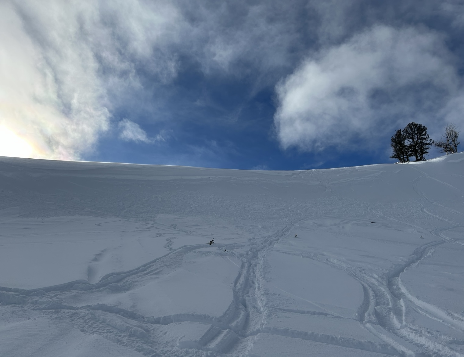
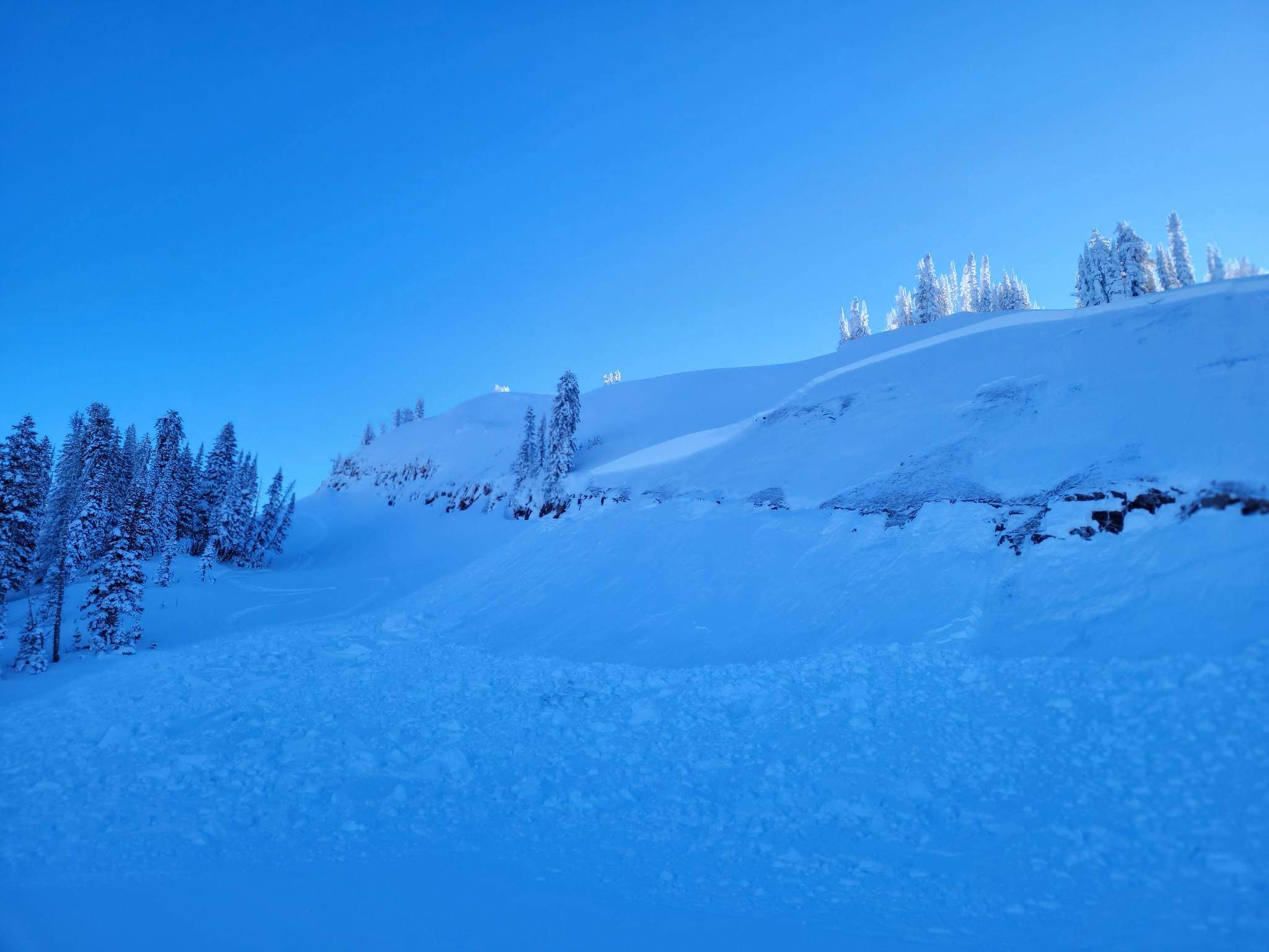
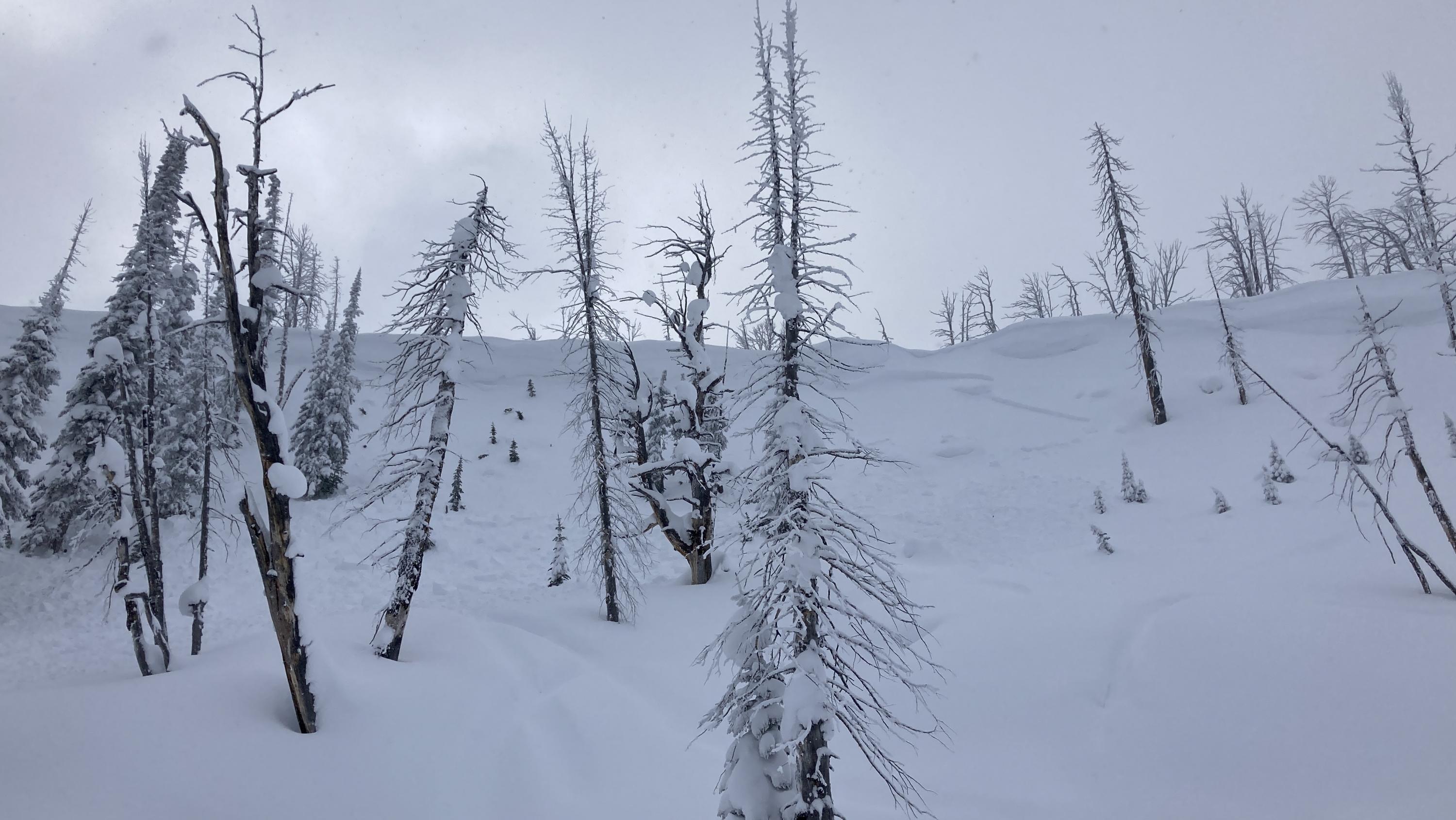
My partner and I were out in a zone south of the bacon rind trailhead today and found some good snow. All of the laps we took today we N NE facing slopes and the snow was supportable and generally stable. We were riding on elevations from 7950 to 7200 all day, and only dug one pit but things were encouraging. I did not do a full profile but we did the usual tests. The total snow height was around 110cm and we got a CT14 Q3 and ECTN12 Q1 both breaking in the now snow around 95cm. Without doing crystal ID and differentiating layers I only got a general hardness scale, from top to bottom it was F-4F-1F+-1F-1F+-4F-G with the section near the ground seeming to be weakening. Overall the snowpack was encouraging but we still kept our riding to lower angle slopes focusing on some pillow lines. No surface hoar was found throughout the day and by the time we left the snow started to fly and the wind stayed light blowing to the northern end of the compass. No recent avy activity was seen on the surrounding slopes. Good snow and good vibes. Thank you all for your hard work, the community appreciates and values what you all do every day!
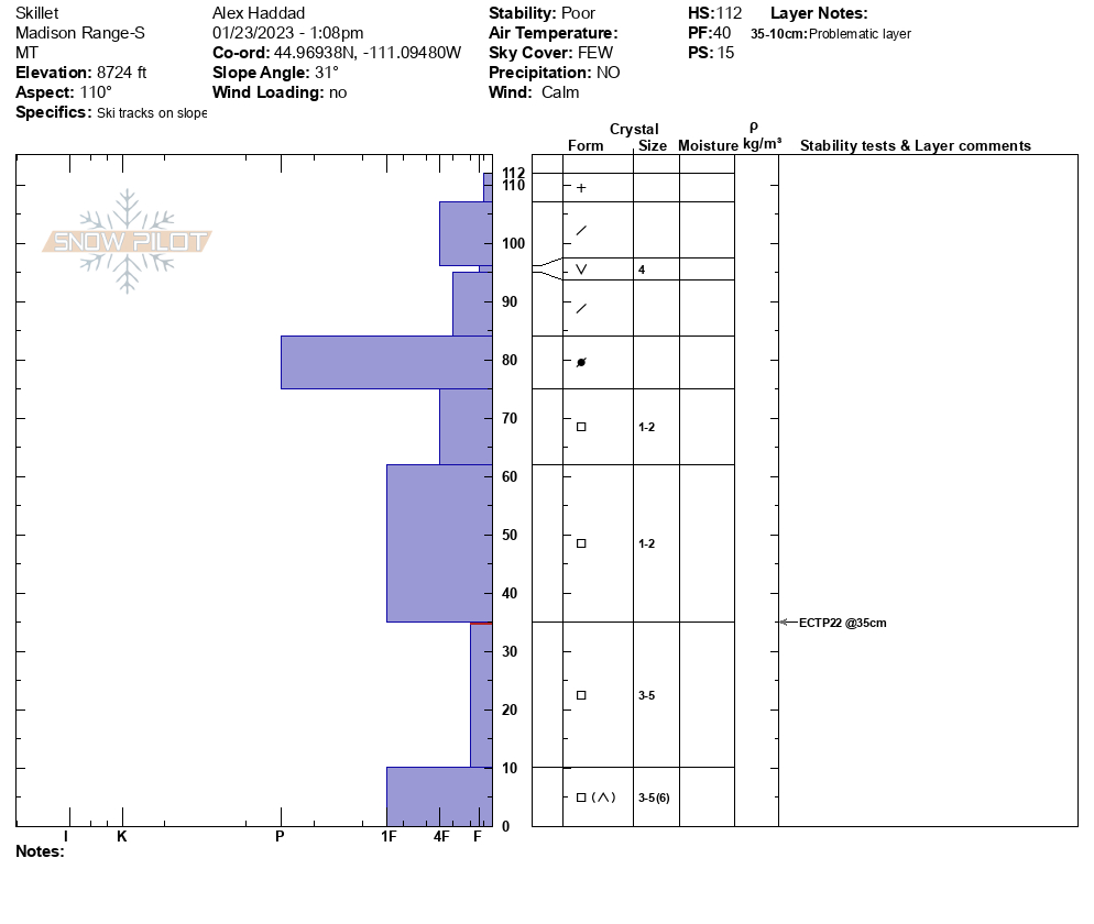
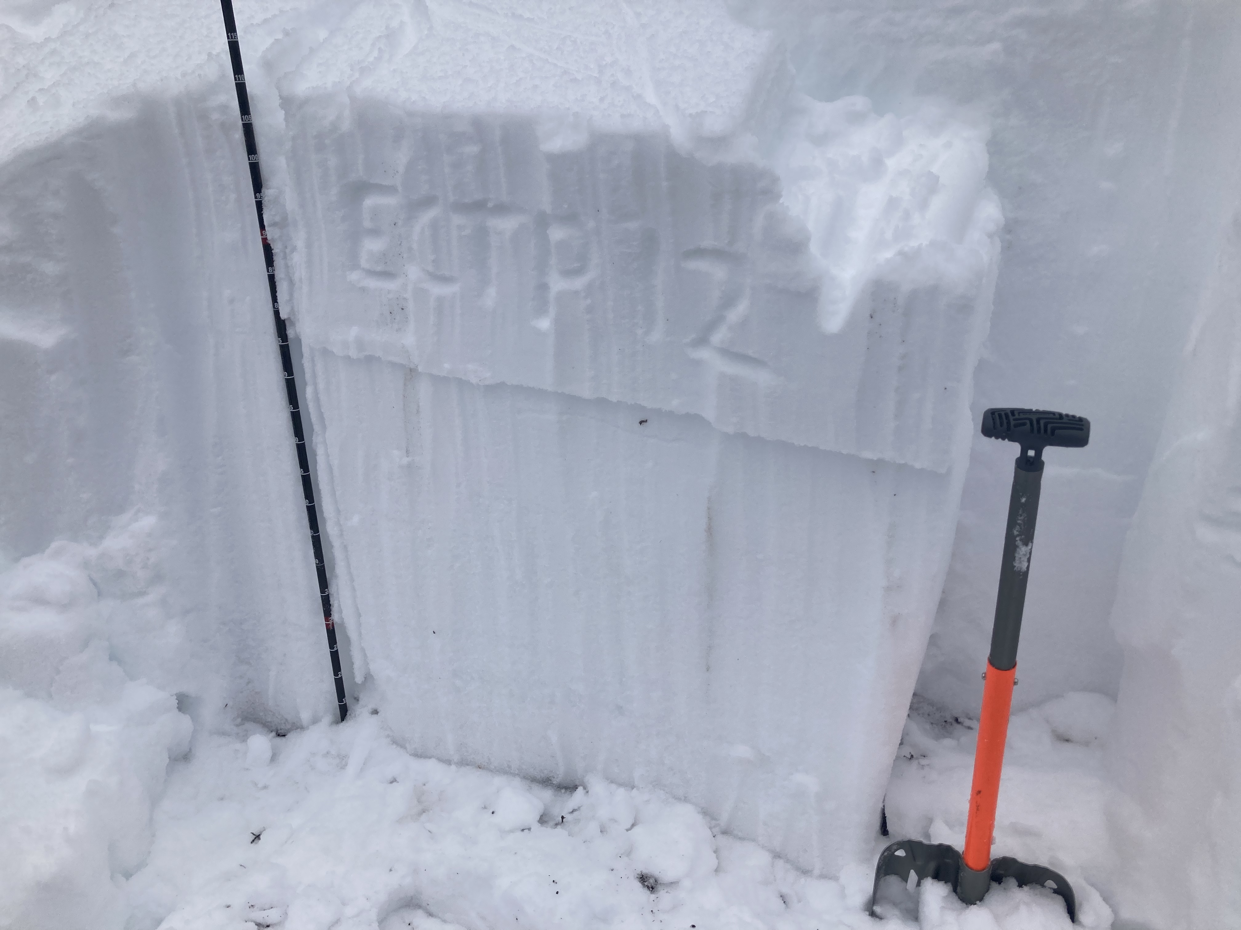
Full Snow Observation ReportWe toured up to the Skillet today. We dug 7 pits on our way up. We found surface hoar buried 6-10” below the surface in all of our pits. This layer failed (ECTN 11 and 12s), but it did not propagate. At this point we were thinking about skiing the Skillet. We dug a pit at the top of the chute at 8,900’. The buried surface hoar was present in this pit, but it did not fail in the ECT. We had an ECTP 22 in facets 2.5’ below the surface of the snow. Because of this result and the terrain traps in the Skillet, we changed our plan and took a more conservative route down. Looking ahead, the buried surface hoar is the primary concern in this area. When we get more snow on top of this layer, instability will increase.
Full Snow Observation Report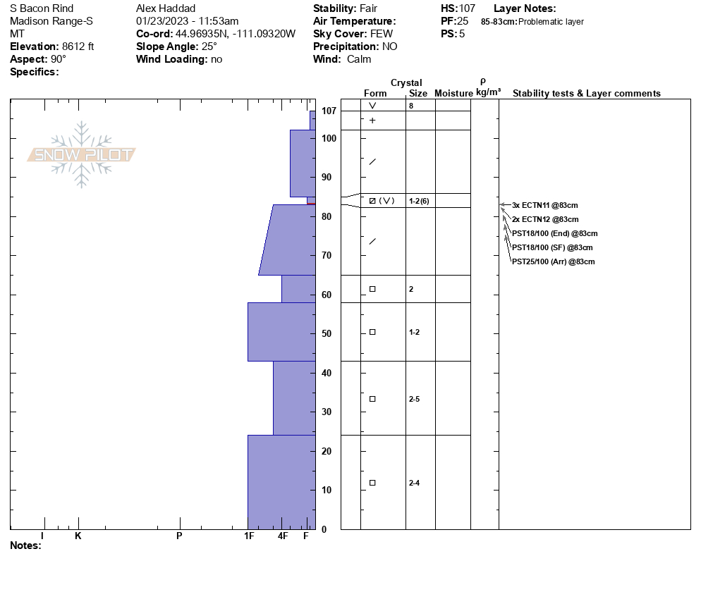

Location. North of Hebgen lake 1/2mi east of white peak.
Elevation 9200ft/ Aspect S
moderate winds with strong gusts. Isolated wind slabs observed.
HS 140
Compression test
CTH4 RP @115. CTH9 BRK @40
Full Snow Observation Report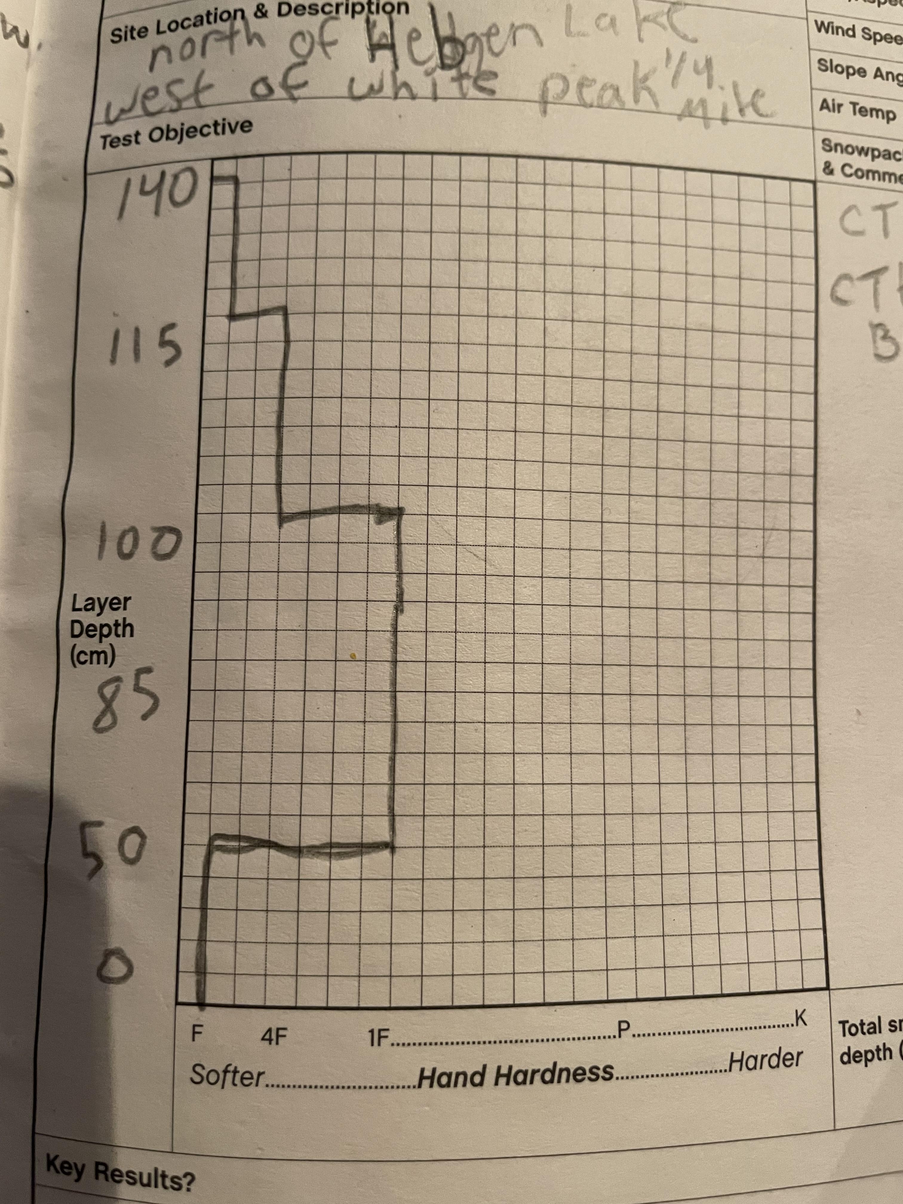
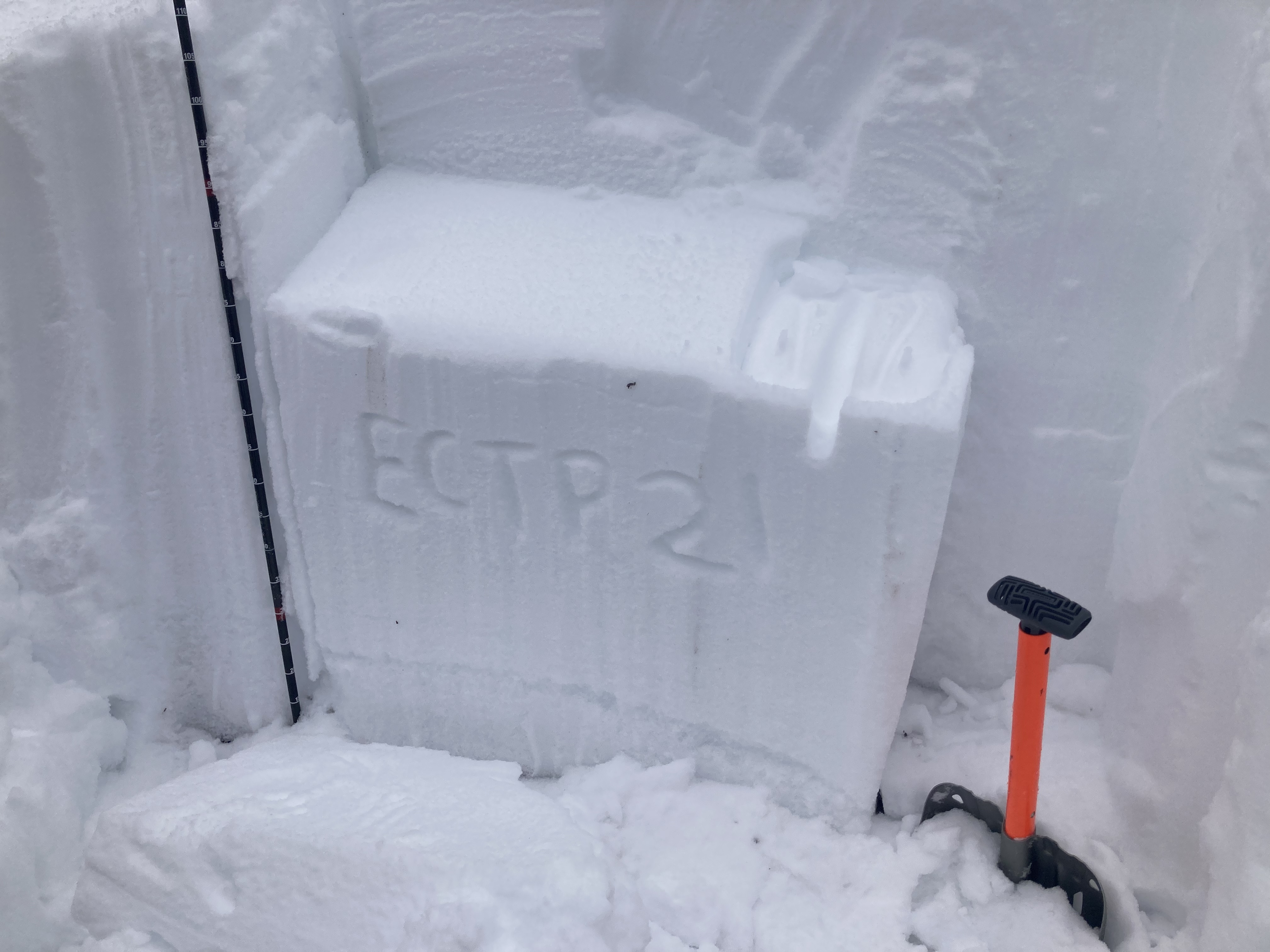
I skied south of Quake Lake today, and we took the time to dig a couple pits along the way. We dug our first one on a west aspect at 7250’, and picked a big meadow to see if we could find the buried surface hoar we found above Hebgen yesterday. I jumped off my skis like I was jumping into a lake, and sank straight to the bottom. Total snow depth was 110 cm, and the surface hoar was not nearly as obvious as it was in our pit above Hebgen. An extended column failed at ECTP12 on the surface hoar, which had much smaller crystals than what we found yesterday. Still, it is not very trustworthy. The pit also failed at ECTP21 on the interface with large facets 20 cm off the ground.
A second pit on a west aspect at 8600’ also failed at ECTP12 on buried surface hoar, but total snow depth was 125 cm and supported our weight well without skis. We observed numerous point releases that entrained enough snow to possibly knock a skier over, but none stepped down and fractured as a slab.
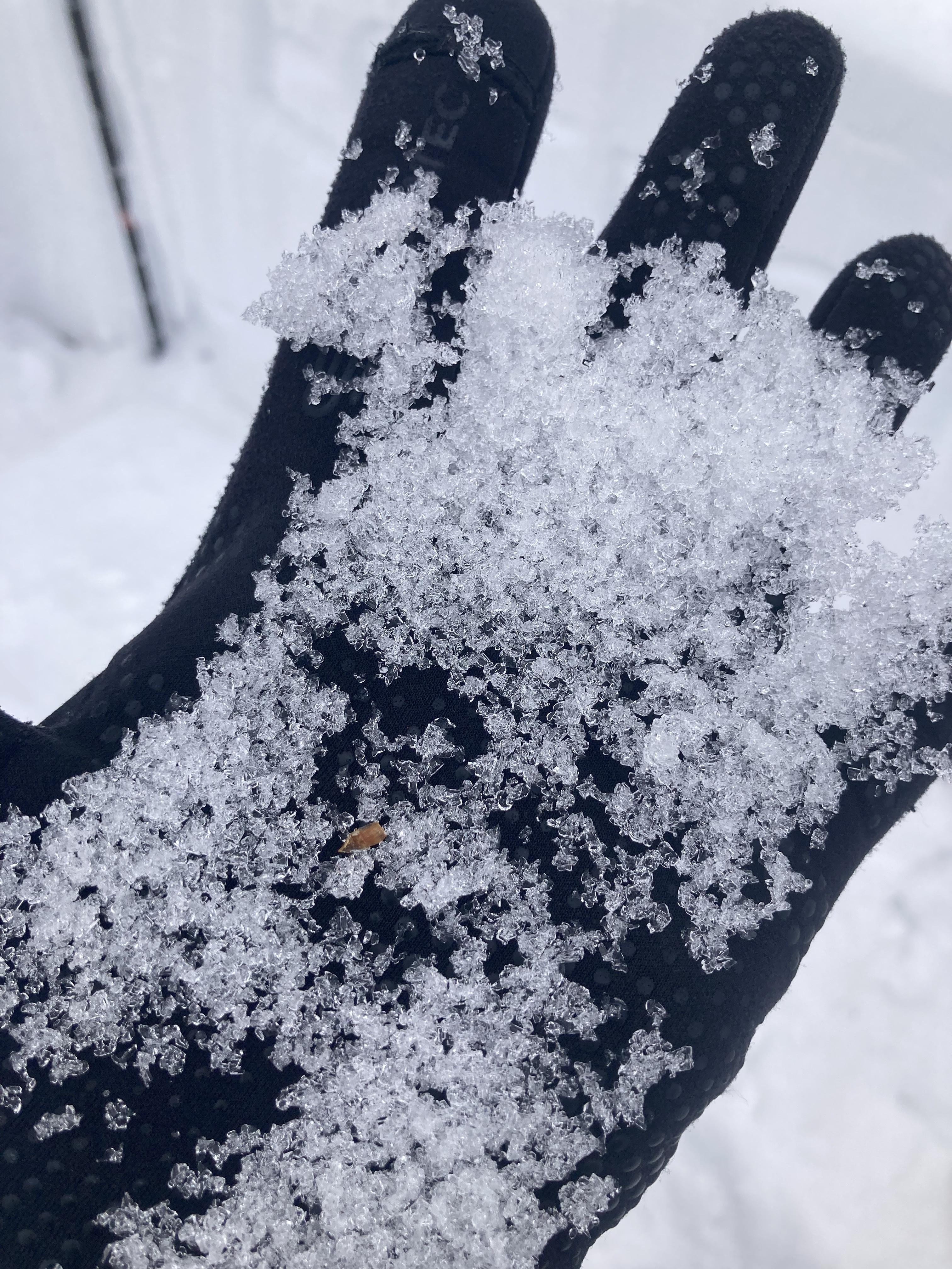
I skied above Hebgen Lake today, and found excellent surface conditions with poor stability. A pit on an east-facing slope at 8650’ had a clear line visible where the buried surface hoar is, and an extended column test yielded ECTN2 10 cm down on the interface between older snow and the new snow from the past couple days, and ECTP7 on the buried surface hoar. This layer is very well preserved. We did not experience any collapsing or cracking and saw no natural slides, but another group triggered two small slides on a he surface hoar while traversing a ridgeline at the top.
Full Snow Observation Report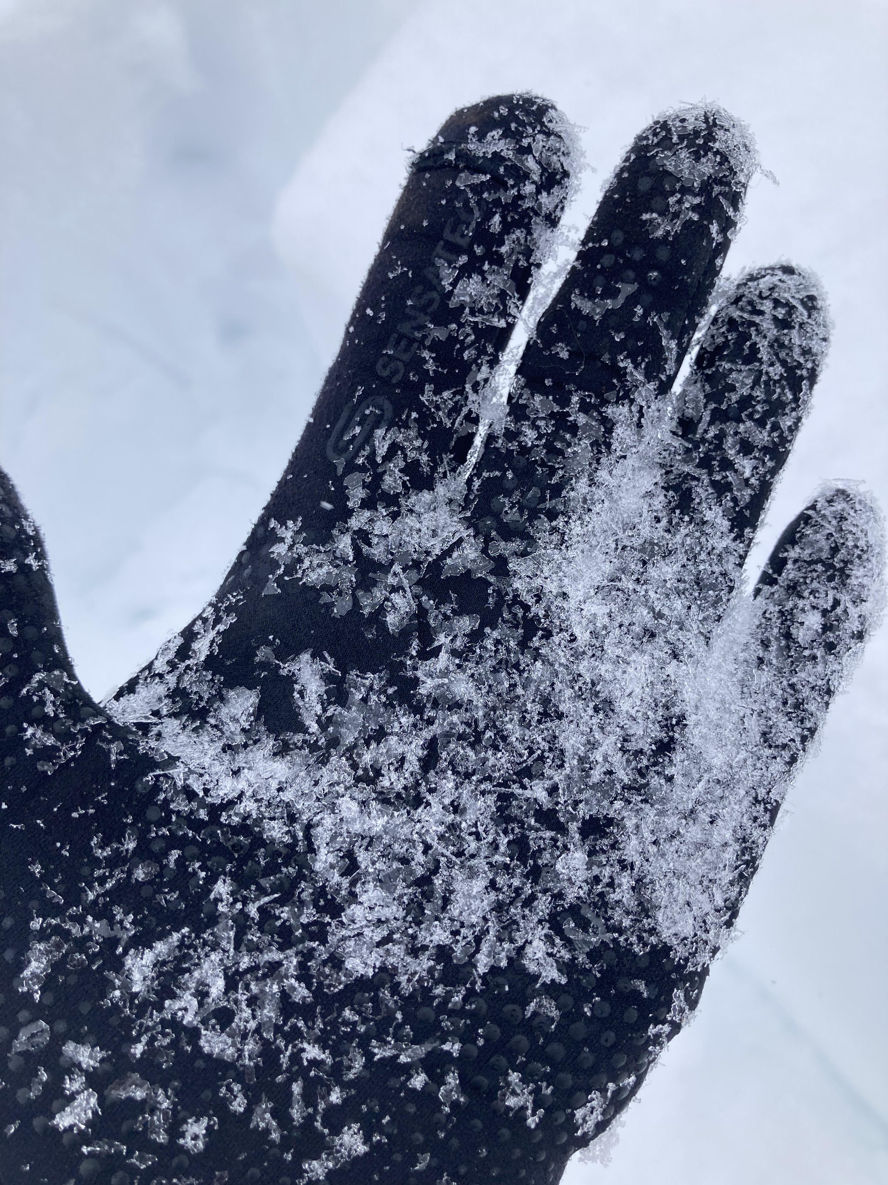
There was 4 inches of new snow in Taylor Fork, and there was wind drifting in several places. We rode to the wilderness boundary to dig a pit. We were on a south aspect at 8,800’. HS 125cm (~4 feet), ECTN5 on surface hoar under the new snow, ECTN21 on facets 1.5 feet below the surface, ECTN 28 on facets near the ground. We rode past the Otter Slide to dig on a north facing aspect, and we had an ECTP5 on buried surface hoar. There was 6” of new snow on top of the surface hoar layer that propagated. While leaving Taylor Fork this afternoon it was beginning to snow. The additional snow in the forecast will likely make this surface hoar layer more reactive now that it is buried. Additionally, the poor structure throughout Taylor Fork could make the deeper weak layers more reactive.
Full Snow Observation Report


Location: 45.165, -111.35808 (onX)
Elevation: ~9,200 feet
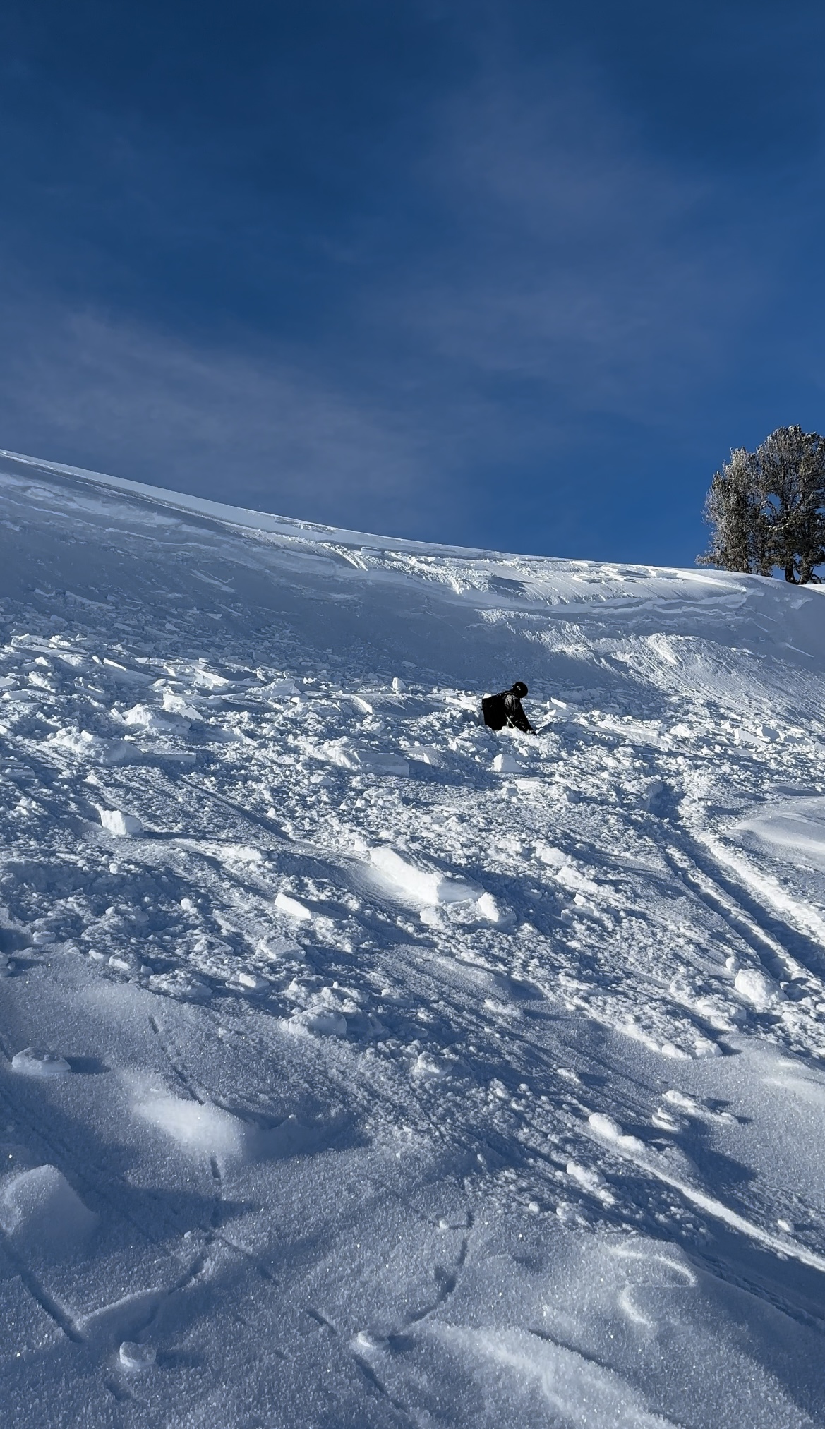
While riding a small NNE facing slope near the trail on Buck Ridge, a snowboarder triggered and followed a cornice slide that propagated approximately 75 feet and slid about 20' vertical. The one rider was caught and carried approx. 10' and ended up buried upright, waist deep with no injuries.
Full Snow Observation Report
I came across this older avalanche yesterday when I was guiding a group in the Kirkwood area, it’s an area in the Cabin Creek drainage. It looked to be an older natural slide probably just after the last storm cycle a few days to almost a week ago now. After seeing the old slide and taking a look we found a safe slope with the same aspect approximately 300 yards away with the same NNE aspect, dug a pit and did an ECT test with stabile results.
Kirkwood
North, North East Aspect
Approximately 39 degree slope (Because of a creek with open water just below the slide, I couldn’t get close enough to accurately measure the slope)
ECTX…When digging the pit we could see what looked like 2 weak layers in the snow pack and a faceted layer at the ground. We had no failures during the test and even after the test when I pulled and pried with a shovel, the snow held together and showed signs of stability.
Full Snow Observation Report
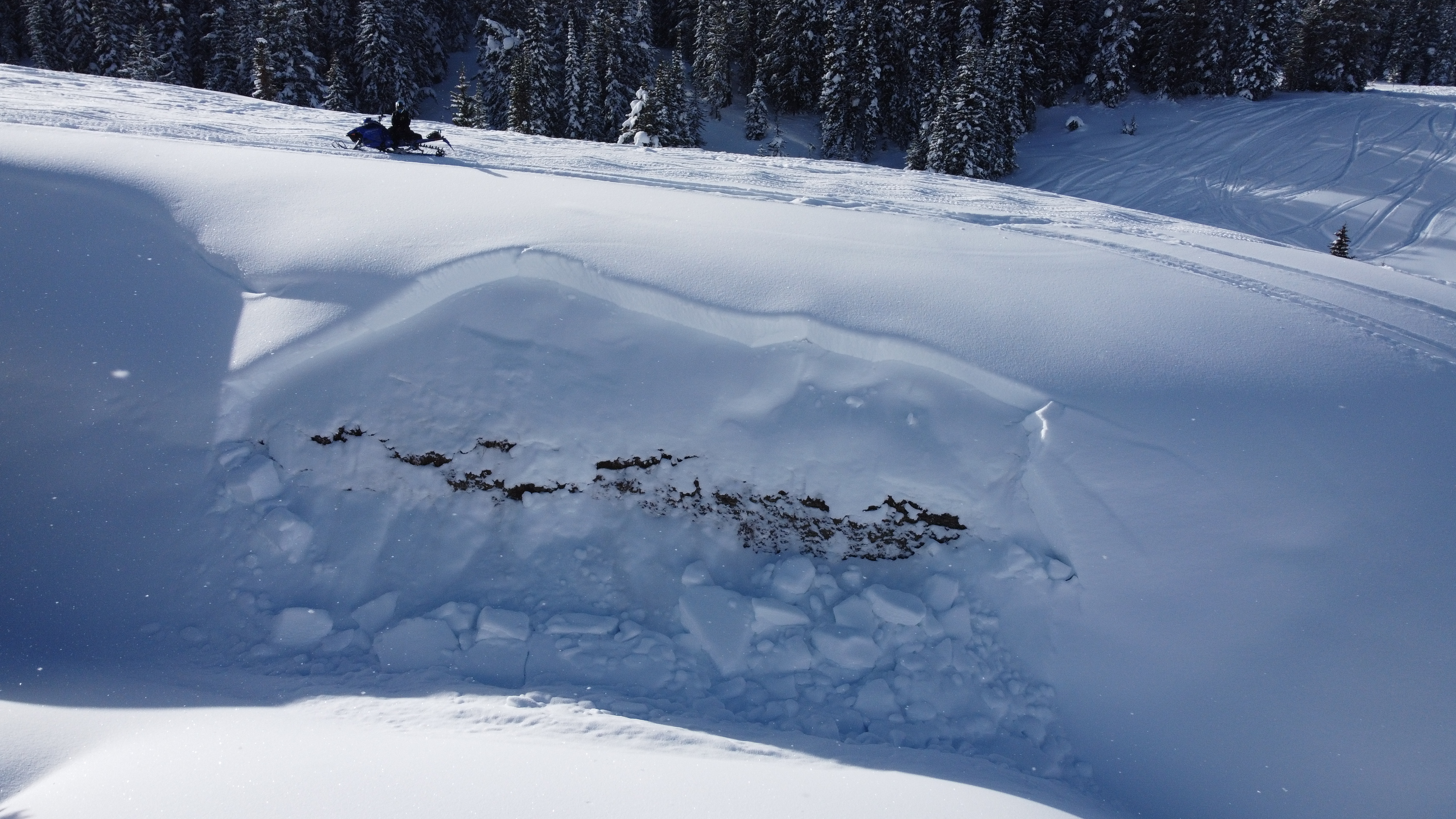
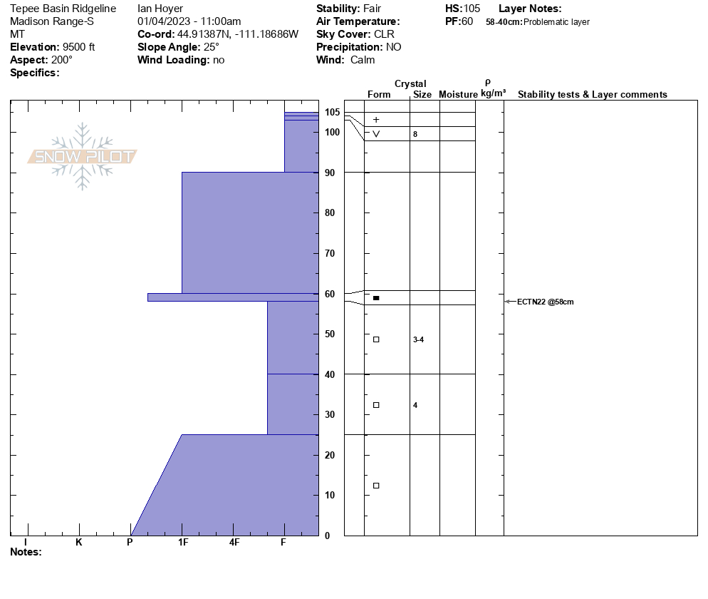
We rode into Teepee Basin first. We had perfect visibility and saw no avalanches. We dug on the far north ridge on a south facing slope: HS 105, ECTN25 on facets about 40 cm off the ground. There is a lack of recent ava activity and ECTN score, which point towards a snowpack trending towards stability, but the snowpack structure is still suspect: facets underlying a slab.
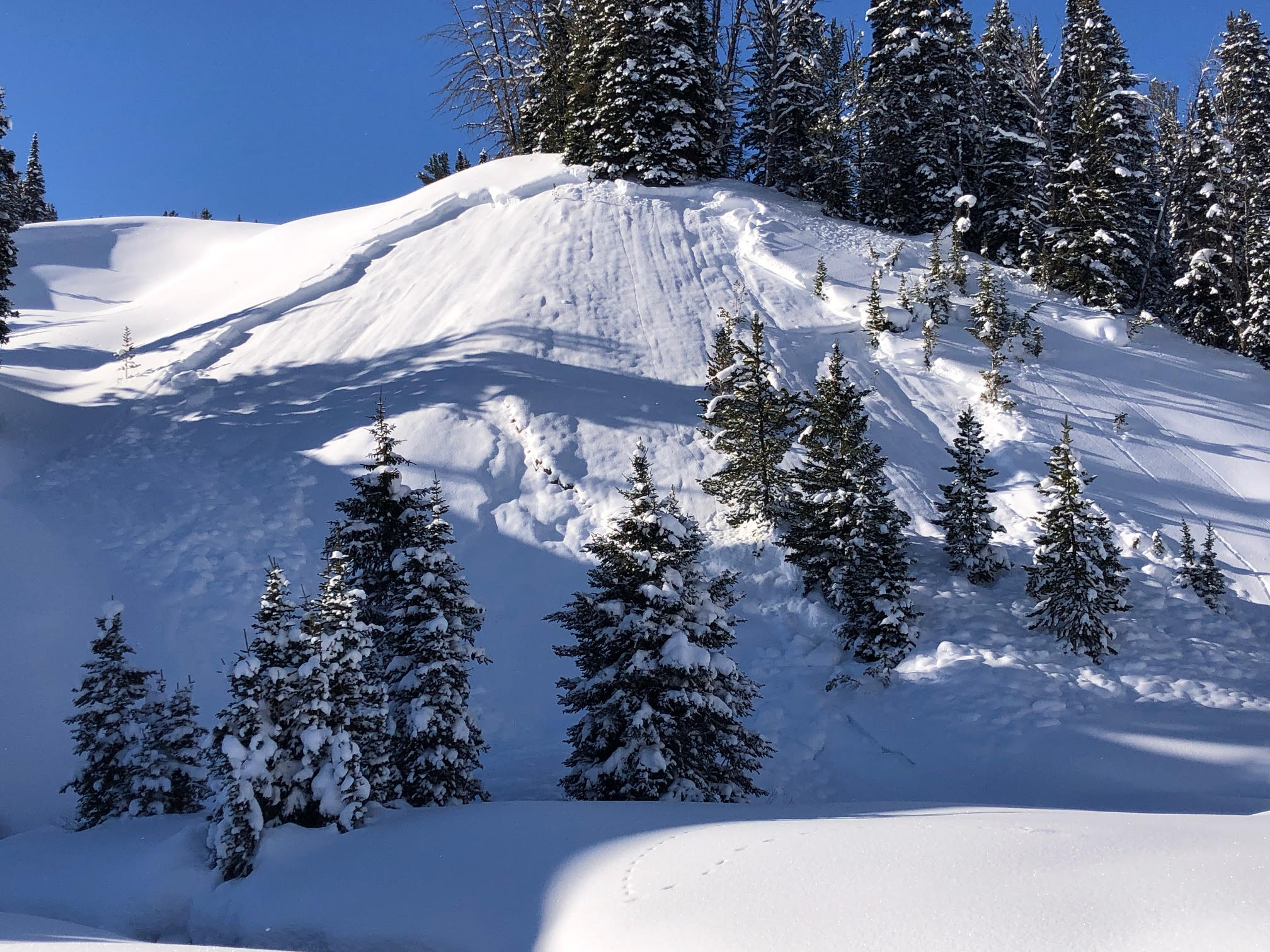
Next we rode to a small and recent avalanche in Cabin Creek. We were alerted to it last night. Although it was steep and wind-loaded, it illustrated the lurking problem we are finding in most areas. Faceted snow is not entirely trusted. We did not see evidence of avalanches on Skyline ridge and folks are starting to climb.
Full Snow Observation Report

From instagram: "Right off the trail at tepee creek just before the cabin. A natural slide about 2ft crown"
Full Snow Observation Report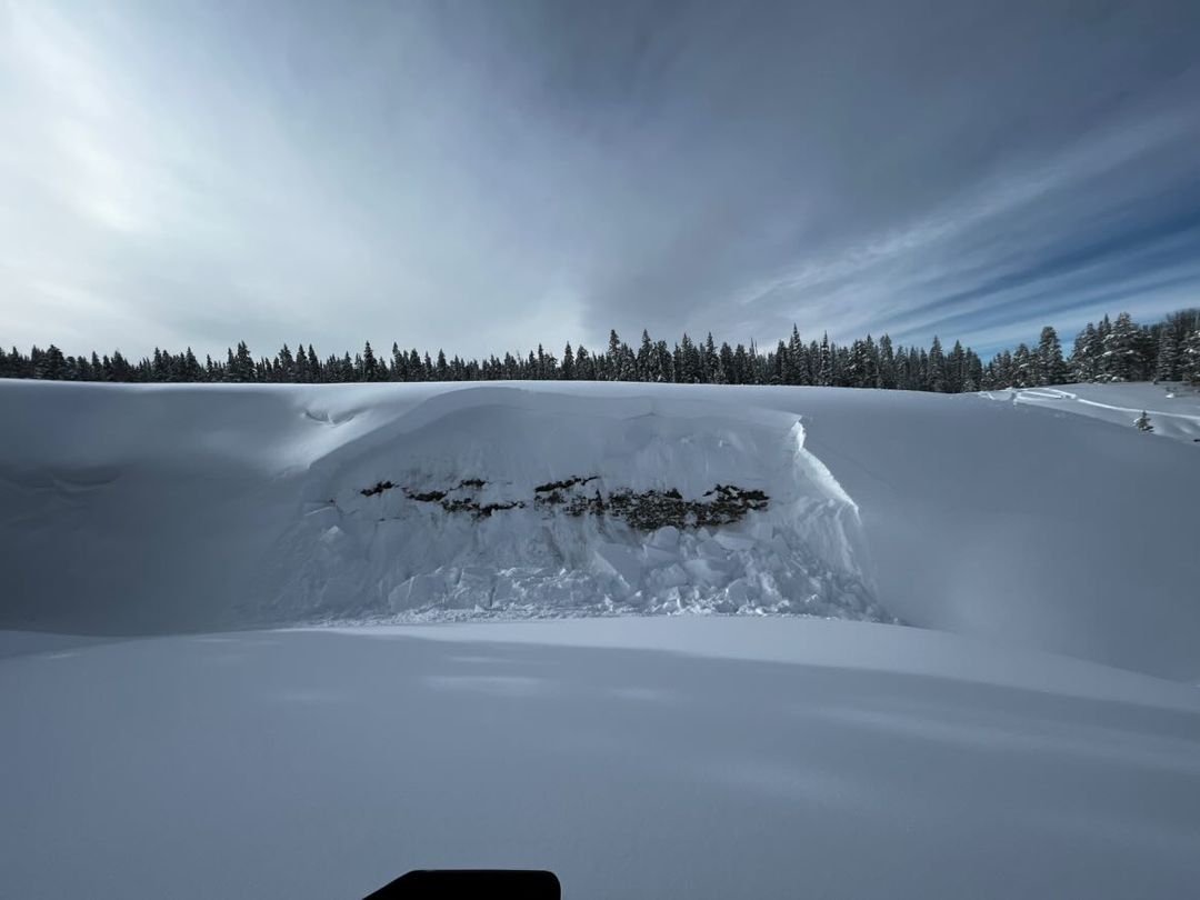
From FB message: “Near Sage Creek/Sage Mountain in carrot basin. This was a east facing, wind loaded slope. Snowmobile triggered below the rock line. No burials.”
Full Snow Observation Report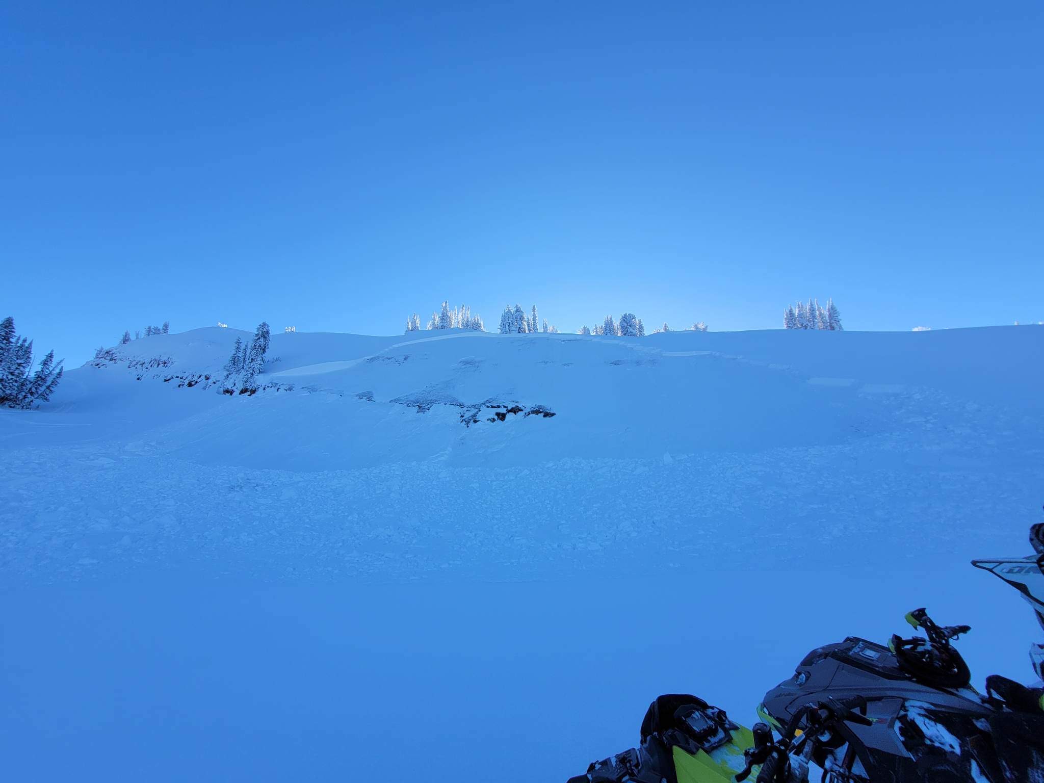
Dug at 9000’ E aspect, HS 110cm ECTN7 down 35cm on .5-1mm facets. 1-2mm F basal facets in bottom 30cm. 2-4 mm SH throughout zone.
Full Snow Observation Report
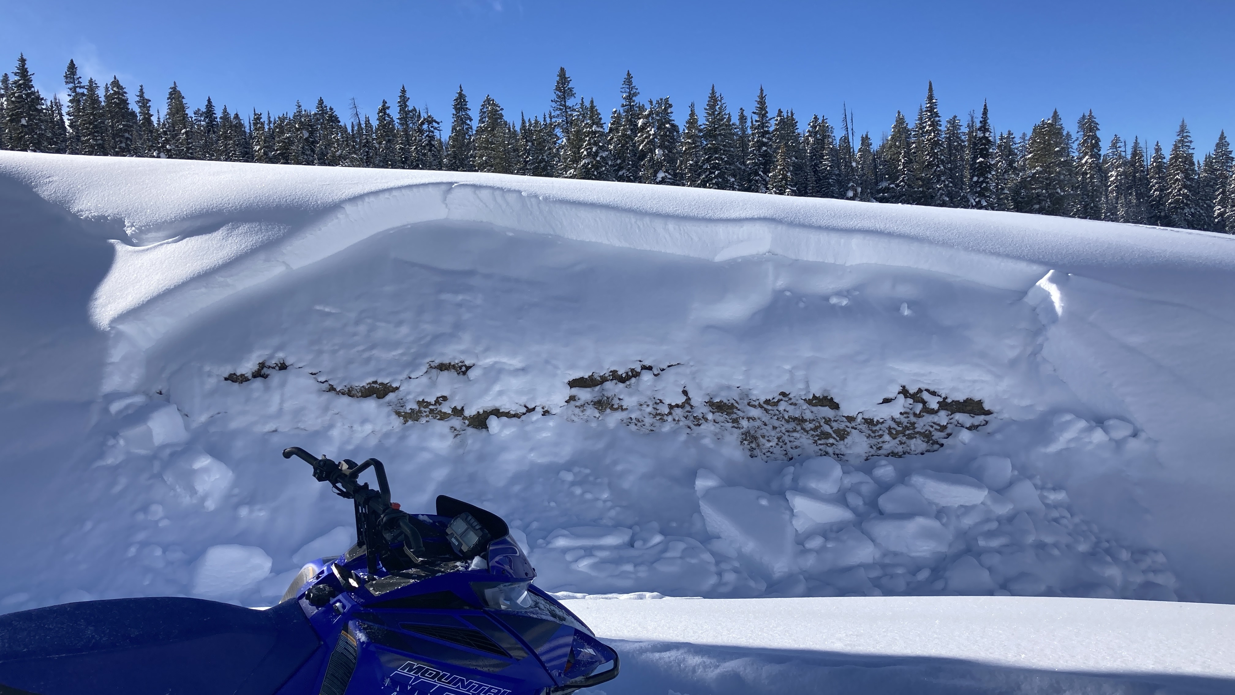
Snow above collapsed into the trench from my sled, looked to have broken on a weak layer about 1.5’ down.
Full Snow Observation Report
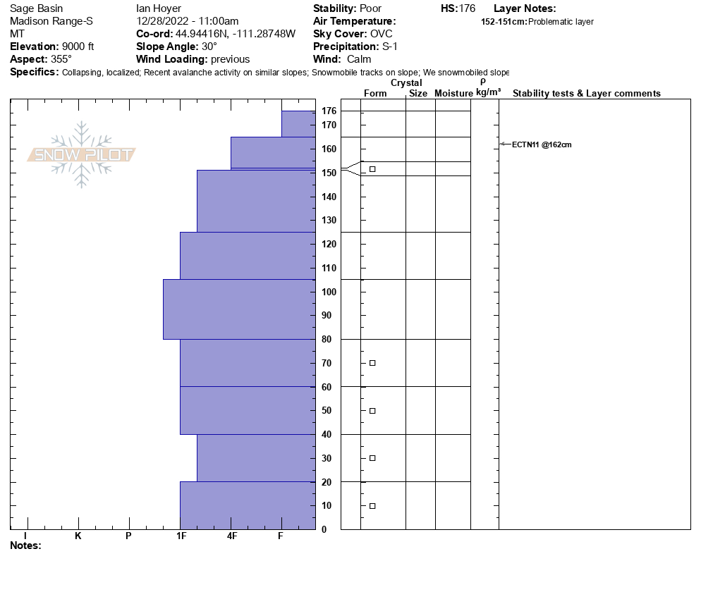
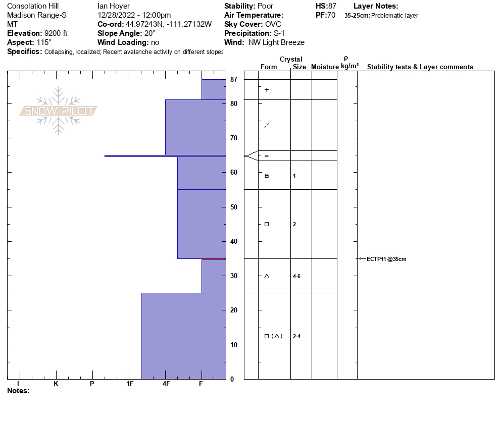
Visibility was good enough so we headed into the weather station and dug on the E facing slope. The instability was concerning and we tip-toed out onto the slope with an inclinometer in hand. It was thin (HS 105) and the 2 prominent weak layers were there: ECTP11 on the upper one and ECTP12 on the facets/depth hoar. We then rode into Sage Basin and found natural avalanche activity on the N facing side. It looked like the slope fractured on the upper layer and on steep terrain it broke to the ground. We dug another on the east end of Sage and had a 176 cm deep snowpack that was unremarkable. On the way out we stopped at Consolation Hill (SE facing) and I got a big whumpf with a body slam as footsteps were just sinking to the ground. This snowpack was thin (HS 87) and it broke on the depth hoar at 35 cm (ECTP11).
Full Snow Observation Report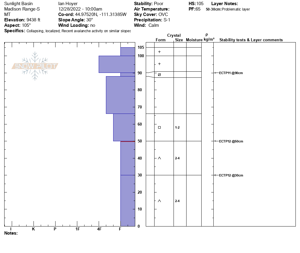

We parked at the bridge and headed up from there. We dug our first pit on a south facing mid-elevation hill. There was 75 cm of snow (HS) a 5 cm thick faceted layer 1 foot deep, then solid snow to the ground. The facets are the same we are finding elsewhere and I got a CT0, which denotes instability. We went to the upper meadow and dug 2 pits (125 and 100 cm HS) but this same faceted layer was thin and not reactive. Neither were the facets in the lower third of the pit. We went to the Skillet and dug there. Again the upper faceted layer was thin and not an issue. The CT0 has me concerned and I am ruling the ECTNs as being irrelevant.
Full Snow Observation Report
We rode from Taylor Fork TH to Carrot Basin. We dug at the wilderness boundary on a SW aspect at 8,800’. HS was 130 cm (~4 feet) with 2x ECTX. We found facets from 100 cm all the way to the ground. However, facets were not our biggest concern today. The wind has drifted 12” of new snow throughout Taylor Fork, and we were unable to see how much wind loading was done on steeper slopes nearby. Low visibility caused by new snow and wind kept us out of avalanche terrain today. Over the next few days in this area, steep, wind loaded slopes should be carefully assessed with an ECT, and riders should watch for cracking and collapsing in the wind drifted snow.
Full Snow Observation Report
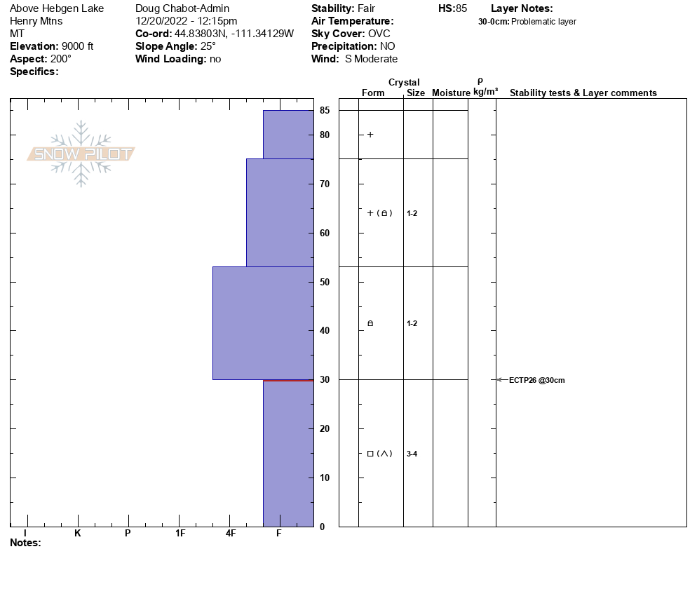
We dug a pit on a SE facing hill at 9,000 feet above Hebgen Lake. We had no signs of instability on the trip up. Near the ridgeline we dug and tested the 85cm snowpack and got an ECTP26 at the interface of the F- weak facets and slab of snow above. The structure was poor, but the snow was relatively stable. It would be possible to trigger a slide in an area where the snowpack is thinner and weaker, and I expect instability to increase with more snowfall.
Full Snow Observation Report

We toured up Bacon Rind to the meadow just south of the skillet. We got a whumpf within 5 minutes of leaving the car and another 5 throughout the day. This told us that the snowpack was unstable and would have kept us out of avalanche terrain regardless of our snowpack test results.Snowpack was generally 3-4 ft deep with ~18 inches of facets at the ground. Dug right where we left the valley floor at the site of our first whumpf (7,100 ft, S aspect) and again again at the top of the main meadow (8800 ft, E aspect). 3 ft of snow in both pits. ECPT18 & ECTP17 on 2 mm fist hardness facets in both pits. This weak snow is unfortunately going to be a problem for quite a while.
Full Snow Observation Report
Sw aspect
7900ft
70cm snow depth
Failure/propagation at 20 cm upon isolation in both CT and ECT on facets at the ground
Full Snow Observation Report