Advisory Archive
This morning temperatures were mostly in the mid 20’s F with SW winds blowing 10-15 mph gusting to 30 mph. Winds were blowing from the NW near Cooke City. Today will be similar to yesterday with mountain temperatures in the mid 30’s F and valley temperatures reaching the 50s F. Winds shouldn’t change much other than shifting a little more westerly.

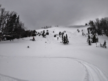
Yesterday morning four inches of dense snow fell in the Bridger and northern Gallatin Ranges while all other areas picked up 1-2 inches. Under clearing skies mountain temperatures are in the low to mid 20s with west to southwest winds averaging 10-15 mph. A strong high pressure system is building today and will block storms until Sunday. Mountain temperatures will reach 40F this afternoon under sunny skies.
This morning the southern areas have three inches of new snow around West Yellowstone, six inches in Taylor Fork and a foot in Cooke City. Snow just started falling and at 6 a.m. Bridger Bowl has an inch of new snow in addition to the inch from yesterday morning which also fell in the northern Madison and northern Gallatin Ranges. Mountain temperatures are in the low to mid 20s with winds out of the west to southwest averaging 20 mph and gusting to 30 mph. Today will remain windy at the ridgetops as temperatures climb to the upper 20s and snow falls. I expect 2-4 inches of new snow in the mountains with closer to six inches around Cooke City before skies clear tonight.

Snow started falling at 5 am this morning and the mountains have picked up 1-2 inches of new snow. At 6 am, mountain temperatures range from the upper 20s to mid-30s F and winds are blowing 15-25 mph out of the W-SW with gusts near 50 mph being recorded in Hyalite and Big Sky. Today, temps will warm into the upper 30s to low 40s F under cloudy skies. Winds will continue to blow 15-25 out of the W-SW with stronger gusts along the ridgelines. A weak storm system will continue to impact the area through the day. The northern mountains will likely receive an additional 1-2 inches of snow by this afternoon while the southern mountains will pick up 2-3 inches. Unsettled weather is likely through tomorrow.
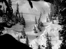
Over the past 24 hours the mountains near West Yellowstone and Cooke City picked up 3-5 inches of heavy, dense snow. The mountains near Big Sky including the northern Gallatin Range picked up 1-2 inches, while the Bridger Range remained dry. This morning, mountain temperatures range from the upper 20s to low 30s F and winds are blowing 15-25 mph out of W-SW with gusts reaching close to 40 mph. Today, temperatures will warm into the mid to upper 30s F under clearing skies. Winds will gradually decrease throughout the day, but will continue to blow 15-25 out of the W. No precipitation is expected over the next 24 hours.

This morning warm and windy weather continued with temperatures in the 30s F and winds averaging 25 mph gusting 40-70 mph from the S and SW. It looked like some snow had started falling this morning near Big Sky at 5 a.m. Today temperatures should only rise a degree or two and may cool a bit this afternoon. Strong winds will continue today shifting a little more westerly. 3-4 inches of snow should fall near West Yellowstone and Cooke City, a few inches near Big Sky, and a trace of snow near Bozeman.

Warm and windy! This morning mountain temperatures ranged from 30 to 40 degrees F with the base area at Bridger Bowl at 48 degrees F. Winds were averaging 20-40 mph and gusting 50-60 mph from the SW. Yesterday at Big Sky winds reached 85 mph in one location. Today will be a mix of sun and clouds with high temperatures approaching 50 degrees F near Bozeman and 40 degrees F in most other places. Strong SW winds will continue today. By tomorrow morning the southern half of the advisory area should get 2-3 inches of snow with more falling during the day on Saturday.
Last night most places received a trace to 2 inches of snow while the mountains near Cooke City received 3-4 inches. Temperatures did not cool overnight and were near freezing in the Bridger Range and mid 20’s F all other places. The big story is winds which were dead calm yesterday morning, but increased significantly this morning averaging 10-20 mph from the SW and gusting 30-50 mph. Snowfall will return late Friday night though we may see a few snowflakes fall between now and then. Strong southerly winds will continue and push temperatures near 30 degrees F or higher today.
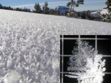
Snowfall yesterday and last night favored the Yellowstone Club with a foot of powder. The northern Madison, Gallatin and Bridger Ranges show 6-8 inches, while only 2-4 inches fell in the south. Winds decreased yesterday afternoon and are currently 5-10 mph out of the west to north. Mountain temperatures are in the mid-teens under mostly cloudy skies. Today will see some sun but cloud up again tonight with a trace to an inch falling by morning.
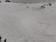
Cooke City received another six inches of snow, most of it falling last night, while the other mountain ranges just received wind. Under mostly cloudy skies mountain temperatures are in the low to mid 20s with west to southwest winds gusting 35-50 mph and averaging 20-30 mph at the ridgetops. Today will be windy and cloudy with snow falling later this afternoon. By morning the northern mountains could have 3-4 inches, the mountains towards West Yellowstone 4-6 inches, and Cooke City 6-10 inches. Winter is back!