Advisory Archive
Over the past twelve hours the Bridger Range received nearly 12 inches of new snow. The mountains near Big Sky including the northern Gallatin Range picked up 3-5 inches while the mountains around West Yellowstone and Cooke City squeezed out 1-3 inches. This morning light snow continues to fall and temperatures are in the teens F. Winds are blowing 10-20 mph out of the W-NW with stronger gusts being recorded around Big Sky. Today, snow will taper off by late morning and temperatures will remain in the teens F. Winds will continue to blow 10-20 out of the W-NW with stronger gusts possible along the ridgelines. Another round of snow will develop late tonight with 2-4 inches possible by tomorrow morning.


Another inversion this morning means the mountains have temperatures in the teens F while valley locations have temperatures below zero F. Today will have some sunshine and temperatures will rise into the 20s F. Winds should blow from the western half of the compass today 10-15 mph gusting to 25 mph. A storm will descend from the NW and snowfall should begin late this afternoon near Bozeman.
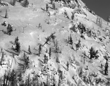
It’s hard to predict when the Bridger Range gets clobbered with snow, but things are lining up for it tonight: NW flow, moisture, cold air, and good lifting. By tomorrow morning, 6-8 inches of snow could fall in the Bridger Range. South of Bozeman and near Big Sky 3-4 inches should fall. Further south near West Yellowstone and Cooke City, 1-3 inches should fall. Saturday should be mostly dry and cold with more snow coming Sunday during the day.

Temperatures this morning in the mountains were in the teens F and rising; however, valley locations had below zero temps like Hebgen lake (-18F) and Gallatin Field (-7F). Northerly winds in the Bridger Range were blowing 20-30 mph this morning, south of Bozeman and near Big Sky they were blowing 15-25 mph, and near Cooke City and West Yellowstone they were blowing 10-15 mph. Today will have some sunshine and temperatures that should reach the 20s F. Winds should calm and blow 5-10 mph all around the compass depending on where you are. Snow should return Friday night through the weekend.


I’m happy to report that mountain temperatures are +10F to +15F this morning, almost 25 degrees warmer than yesterday, because of an inversion (although it’s not as strong in the Bridger Range: +5F). Skies are mostly clear and winds shifted from the east to north and are currently averaging 15 mph with gusts reaching 30 mph. Today will be sunny as mountain temperatures climb towards 20F and ridgetop winds continue to blow steady out of the north to northwest.

Today freezing cold east winds will dominate the weather. After lots of snow over the weekend, winds shifted yesterday from the west to the east and blew 30-40 mph in the Bridger Range and 10-20 mph elsewhere. An arctic airmass pushed in last night and dropped temperatures to -15F to -22F in the mountains. Temperatures may reach the single digits today and drop to near -20F again tonight before a gradual warming trend tomorrow.


Over the past 24 hours the Bridger Range received close to a foot of new snow. The mountains near Big Sky including the northern Gallatin Range picked up 3-6 inches while the mountains near West Yellowstone and Cooke City picked up 2-3 inches. At 4 a.m. mountain temps are in the single digits above or below zero F and winds are light out of the E-NE. Today, temperatures will struggle to climb above zero F under partly cloudy skies and winds will remain light out of the E-NE. Calm and cold weather is in store for the next 24 hours.

Over the past 24 hours the Bridger Range has received over a foot of new snow. The rest of the advisory area has picked up 4-6 inches. At 4 a.m. it’s still snowing and temperatures are in the single digits to low teens F. Winds are blowing 10-20 mph out of the W-NW. Today, snow will continue with an additional 2-4 inches likely in most areas. The Bridger Range could see up to 6 inches by tonight. Today, temperatures will warm into the upper teens to low twenties F and winds will continue to blow 10-20 out of the W-NW. Cold air arrives tonight with lows dropping well below zero F.


Flurries near Bozeman produced a trace of snow yesterday. Overnight temperatures dropped to a few degrees either side of zero F with WSW winds blowing 10 mph gusting 15-30 mph. Today temperatures should make it into the teens F, and winds will increase slowly with an approaching storm. Snow should arrive this afternoon. By tomorrow morning 3-5 inches should fall in most places with more falling during the day on Sunday.


Early yesterday many places received another inch or two of new snow before the storm ended. Today will be calm and cold. Temperatures this morning were in the single digits F except near Cooke City where temperatures were a few degrees below zero F. Winds were blowing 5-10 mph gusting 15 mph from the N and W; however, Lionhead near West Yellowstone had north winds averaging 25 mph gusting to 33 mph. Today temperatures should climb into the teens F and maybe break into the 20s F in a few spots. Winds will remain light. The mountains near Bozeman and Big Sky may see flurries. More snow should arrive late Saturday.
Overnight 7-11 inches of snow fell near Big Sky and in the Bridger Range, 6-8 inches in the mountains near West Yellowstone and Cooke City, and 5 inches in the northern Gallatin Range and Hyalite Canyon. Temperatures this morning were in the mid-teens F and dropping as cold air descends from the north. Yesterday winds blew from the SW then shifted to the north overnight and were blowing N and NE 10-15 mph this morning gusting 20-30 mph.
Snow should continue this morning with another 2-4 inches falling but taper off by midday. Temperatures will fall to the single digits F and N/NE winds will increase this morning. More snow should arrive Saturday night.