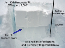
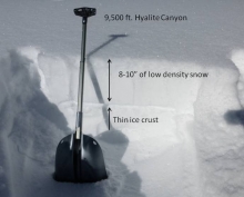
Advisory Archive
Mountain temperatures were in the teens to low 20s F this morning. Winds were blowing 10-15 from directions ranging from SW to NW. In the Bridger Range, however, winds were blowing 20-40 mph from the W and S. Clouds moved over the area last night, and an inch of snow may fall this morning. The sun should start to appear this afternoon when temperatures climb into the upper 20s and low 30s F. Winds should blow from the W and NW at 10-20 mph and may continue to blow stronger in the Bridger Range.


This morning with another inversion, temperatures in the mountains were in the mid-teens F in most places but single digits near West Yellowstone and Cooke City. Near Bozeman winds were blowing 20-30 mph from the W, and in all other areas blowing 15-20 mph. Today should have sunshine and temperatures will warm into the 20’s and low 30’s F.
Last night a rogue squall dropped an inch of snow up Hyalite and dusted Bozeman just enough to be annoying. Mountain temperatures have fallen into the single digits except in the Bridger Range where they are in the teens. Westerly winds have calmed to 5-15 mph. Today will be sunny, winds will remain calm and mountain temperatures will climb into the 20s.


Last night two to three inches of snow fell in the mountains with the exception of the Lionhead area which was missed. Mountain temperatures have cooled to the low teens with winds averaging 10-15 mph out of the west with gusts of 25 mph. Snow showers will add another inch or two this morning before skies clear and high pressure builds this afternoon. Today temperatures will reach the lower 20s and winds will remain moderate.
Over the past 24 hours the mountains around Cooke City picked up eight inches of new snow. The Bridger Range received a surprise three inches while the mountains around Big Sky and West Yellowstone picked up a trace to one inch. This morning, mountain temperatures range from the upper teens to mid-twenties F under mostly clear skies. Winds are strong out west blowing 15-30 mph with gusts reaching close to 50 mph in many locations. Today, temperatures will warm into the mid to upper twenties F and winds will remain moderate to strong out of the west. Skies will become mostly cloudy as the day progresses and there is an increasing chance of mountain snow showers by this afternoon. Accumulations of 1-2 inches are possible by this evening.
Overnight the mountains around West Yellowstone and Cooke City received 3 inches of new snow. The mountains around Big Sky picked up 1-2 inches while the Bridger Range remained dry. This morning snow continues to fall in the mountains south of Bozeman and temperatures range from the upper teens to mid-twenties F. Winds are blowing 15-30 mph out of the W-SW with ridgetop gusts over 40 mph being recorded near Big Sky and Hyalite. Today, temps will warm into the upper twenties to mid-thirties F and winds will continue to blow 15-30 out of the W-SW. Snow will continue through the day in the mountains south of Bozeman. An additional 3-5 inches is likely around West Yellowstone and Cooke City while the mountains around Big Sky will pick up 2-4 inches. The Bridger Range might squeeze out 1-2 inches. Snow will taper off this evening and temperatures will drop into the teens F.
Over the past 24 hours the mountains around Cooke City picked up seven inches of new snow. The mountains around West Yellowstone and Big Sky picked up 2-4 inches while the mountains around Bozeman remained mostly dry. Currently, mountain temperatures range from the teens to low twenties F and winds are blowing 15-30 mph out of the W-SW. Today, a weak ridge of high pressure will produce mostly clear skies and calm conditions. Temperatures will warm into the upper 20s to low 30s F. This period of nice weather will be short lived as another storm system approaches from the west. By this evening skies will become mostly cloudy and winds will gradually increase. The mountains south of Bozeman could see 1-3 inches of new snow by tomorrow morning with higher amounts likely by tomorrow evening.

Ahead of an approaching storm, winds increased this morning and were averaging 10-20 mph gusting 30-40 mph from the SW. Temperatures were in the teens to low 20s F. Winds should stay strong through the morning and ease some this afternoon when it should start snowing mostly in the southern half of the advisory area. By tomorrow morning the mountains near Cooke City and West Yellowstone should get 2-4 inches while further north the mountains may only get about an inch. The sun should appear Saturday morning before more snow comes Saturday evening.
Today will have more sunshine and warm weather. With an inversion in place this morning, mountain temperatures were in the mid 20s F, and westerly winds were blowing 10-15 mph gusting 25 mph. Temperatures today will rise to the high 20s and low 30s F. Winds will shift to the SW and blow 10-20 mph. Some snow should come Friday afternoon.

Like yesterday, today will be sunny but a little warmer. Currently mountain temperatures are in the high teens to low 20s. Winds are westerly and blowing 20-30 mph in the Bridger Range and Hyalite and 10-20 mph everywhere else. Winds will remain the same and temperatures are expected to rise into the low 30s as high pressure continues to dominate our weather.