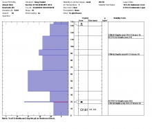
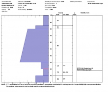
Advisory Archive
This morning Snotel sites and Bridger Bowl weather stations were down so I do not have accurate snow totals for much of our advisory area. With that said, it appears (through various webcams) that most areas received 2-3 inches of high density snow. At 4 a.m. temperatures are in the teens F and winds are blowing 10-20 mph out of the west with gusts reaching close to 30 mph in the mountains around Cooke City. Today, light snow will continue through the morning hours with an additional 1-2 inches possible. Snow will taper off by this afternoon and skies will become partly to mostly cloudy. Temperatures will warm into the 20s F and winds will continue to blow 10-20 mph out of the west. A weak ridge of high pressure will gradually build over the area producing dry conditions through tomorrow.


Overnight no snow fell. Winds calmed and this morning were blowing 5-10 mph gusting to 25 from the SW to SE except in Hyalite Canyon where they continued blowing 30-50 mph. Temperatures this morning were in the high 20s to low 30s F. Today temperatures should drop and moisture will move over the area as winds shift a little more westerly. By the end of the day most places will have temperatures in the mid 20s F and 1-3 inches of snow.
This morning temperatures were in the low 30s F, and strong south winds continued blowing 20-30 mph gusting 50-70 mph. Temperatures should warm into the mid to upper 30s F today and strong southerly winds will continue. The exception is the Bridger Range which did not have such strong winds yesterday or this morning. Clouds will build this afternoon, and late tonight 1-2 inches of snow should fall near West Yellowstone. Other areas may get a trace of snow. A cold front passing through the area tonight will bring calmer winds and cooler temperatures tomorrow.

A deepening trough of low pressure off the west coast will bring warm and windy weather today and precipitation Friday night. This morning temperatures were near 30 degrees F except in the Bridger Range where they were in the mid 40s F. Winds increased overnight and were blowing 20 mph from the S and SW gusting 30-50 mph. Today will have more sunshine and temperatures in the 30s and 40s F with continued strong, southerly winds.
We are living under a dome of high pressure which is bringing unseasonably warm temperatures and mostly clear skies. Yesterday, mountain temperatures spiked into the upper 30s to low 40s and cooled last night to freezing. Today will be partly cloudy and warmer with southwest winds blowing 15-25 mph. Weather models are showing this ridge of mountain biking weather to continue into Friday.

Today’s weather is dominated by high pressure which is basically, sunny, warmish, calm and boring. This morning, mountain temperatures are in the mid-20s as southwest winds blow 15-25 mph at the ridgetops. For today, winds will lessen and temperatures will climb into the low 30s with clouds increasing tonight, but sadly, no snow.
A stationary ridge of high pressure has produced quiet weather over southwest Montana. This morning, mountain temperatures are in the upper 20s to low 30s F under mostly clear skies and winds are blowing 10-20 mph out of the WSW. Today, temps will warm into the mid to upper 30s F and winds will remain light to moderate out WSW. High pressure will continue to dominate the weather pattern over the next few days.

Over the past 24 hours the mountains around Cooke City received three inches of dense snow; the rest of the advisory area picked up 1-2 inches. At 4 a.m. mountain temperatures range from the mid 20s to low 30s F and winds are blowing 10-20 out of the WSW. The one exception is Cooke City were winds are cranking 20-30 mph with gusts in the 40s. Today, a ridge of high pressure will build over the region producing clear skies and warm temps by this afternoon. Mountain temps will warm into the mid to upper 30s F and winds will continue to blow 10-20 out of the WSW with stronger gusts along the ridgelines. High pressure will remain parked over the area producing dry and even warmer conditions tomorrow.
Winter has taken a brief hiatus making way for almost spring like conditions. At 4 a.m. temperatures are in upper 20s to low 30s F and winds are blowing 10-20 mph out WSW with stronger gusts along the ridgelines. Today, temperatures will warm into the upper 30s F under partly cloudy skies and winds will gradually increase out of the WSW. A weak weather disturbance will move into the area this evening producing mostly cloudy skies, stronger winds and a slight chance of snow. The mountains around Big Sky, West Yellowstone and Cooke City will likely see an inch of snow by tomorrow morning.

Since yesterday morning the mountains near Cooke City received 6 inches of snow while all other areas received 1-2 inches. Winds calmed this morning and were blowing 10-15 mph from the W and SW with temperatures in the mid to high 20s F. The sun should appear this afternoon with high temperatures near 32 degrees F. Winds will remain about the same. A little bit of snow may come late Saturday.