Good morning. This is Mark Staples with the Gallatin National Forest Avalanche Advisory issued on Friday, January 6 at 7:30 a.m. This advisory is sponsored by Montana Import Group in partnership with the Friends of the Avalanche Center. This advisory does not apply to operating ski areas.
Temperatures dropped overnight and were in the mid teens F this morning. Winds were averaging 5-15 mph from the NW with gusts of 25-40 mph. No snow fell overnight and today will be mostly sunny. Winds will blow 10-20 mph from the W and NW, and temperatures will climb into the mid 20s F.
AVALANCHE INCIDENTS
Final reports on last weekend’s avalanche accidents are available at: http://www.mtavalanche.com/accident
A resident of Cooke City hiked into Hayden Creek yesterday and confirmed that Ole the dog survived for 4 days buried 3ft deep. He likely heard Doug and Karl walking on the debris conducting the accident investigation while he was still buried. A video was posted documenting this tale of survival.
The Bridger, Madison and southern Gallatin Ranges, the Lionhead area near West Yellowstone and the mountains around Cooke City:
The snowpack remains unstable even though it’s been nearly a week since the last snowfall. Unfortunately one week of warm temperatures is not enough to improve stability, and the structure of this season snowpack means that it can remain unstable for a long time. Yesterday my partners and I skied north of Bridger Bowl. The surface snow had been affected by recent warm temperatures, but facets in the bottom half of the snowpack remained unchanged and weak. Our stability test scores were low and indicated unstable conditions (photo, video). They were similar to what Karl found on Lionhead on Wednesday (photo, video), and what snowmobilers found yesterday in the Taylor Fork area. A recent avalanche (photo) in the Taylor Fork confirmed this instabilitiy. Skiers in the Dudley Creek area near Big Sky also found weak and unstable snow.
Now is a difficult time. Without more snow, the danger will decrease very slowly. Signs of instability will become less obvious and avalanches will become slightly harder to trigger. In fact the snowpack may even let a few people ski or ride on a slope before it avalanches. Don’t let tracks on a slope trick you into thinking it’s stable. A recent visitor from Utah said it best: Right after this weekend’s storm skiing or riding in avalanche terrain was like playing Russian roulette with a bullet in 5 of the 6 chambers. Now it’s like playing Russian roulette with a bullet in 1 of the 6 chambers.
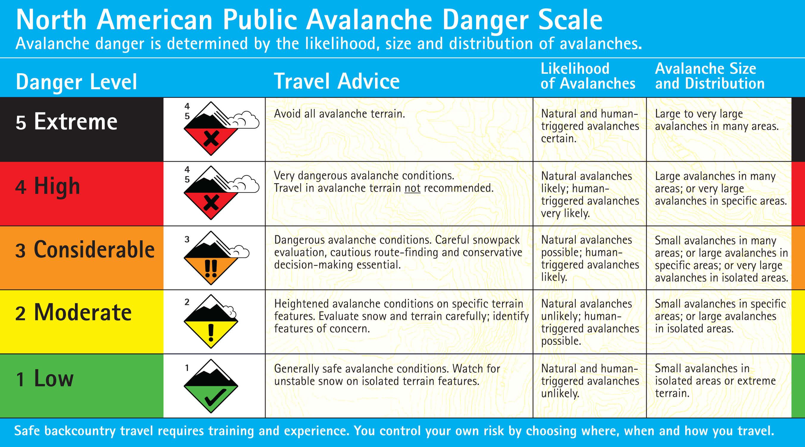
Rating the avalanche danger is difficult. There are three categories that describe each danger rating: travel advice, likelihood, and size & distribution. The likelihood of triggering an avalanche and the size & distribution are slowly changing. Travel advice is not. For today, based on travel advice, I’m rating the avalanche danger CONSIDERABLE. This means dangerous avalanche conditions exist, and these conditions require careful snowpack evaluations, cautions route-finding, and conservative decision making. See the complete danger scale here.
The northern Gallatin Range:
Stability is better in the northern Gallatin Range. On Wednesday Eric and his partners skiied in Hyalite Canyon where they found obvious facets near the ground, but thought it would be difficult to trigger an avalanche on this layer. They also saw evidence of a large cornice that broke and hit the slope below but did not trigger an avalanche – a good sign. Some areas have a layer of surface hoar buried about a foot deep. I found it on Mt Ellis (snowpit, photo) and did not ski steeper open areas under the burn based on the existence of this layer. Buried surface hoar was also found near Lick Creek. With buried surface hoar on some slopes and some facets near the ground, human triggered avalanches are possible and the avalanche danger is MODERATE.
Eric will issue the next advisory tomorrow morning at 7:30 a.m. If you have any snowpack or avalanche observations, drop us a line at mtavalanche@gmail.com or call us at 587-6984.
EVENTS/EDUCATION
To check out all our education programs: http://www.mtavalanche.com/workshops/calendar
BOZEMAN
Snowmobiler Introduction to Avalanches with Field Course. Lectures on Saturday, January 7, with an all day field session Sunday, January 8. Advanced registration IS REQUIRED.
1-hr Avalanche Awareness Lecture. Wednesday, January 11, 6:30-7:30 p.m. at REI.
20/20 Hindsight - Lessons from recent accidents. Tuesday, January 17th, 6:30-7:30 p.m. at Montana Import Group
BIG TIMBER
1-hr Avalanche Awareness Lecture. Tuesday, January 10, 7-8 p.m. at Big Timber High School.
HELENA
1-hr Avalanche Awareness Lecture. This class was rescheduled for the 3rd week of January. The exact day has not been determined. Stay tuned.
COOKE CITY
1-hr Avalanche Awareness Lecture. Saturday, January 14, 5-6:00 p.m. at Cooke City Community Center.
CODY, WYOMING
Snowmobiler Introduction to Avalanches with Field Course. Lectures on Saturday, January 14 at Mountain Valley Motorsports with an all day field session near Cooke City on Sunday, January 15. Advanced registration IS REQUIRED.
BILLINGS
Snowmobiler Introduction to Avalanches with Field Course. Lectures on Tuesday, January 24 from 6-9 p.m. at Hi-Tech Motor Sports with an all day field session in Cooke City on Sunday, Jan 29. PRE-REGISTER BY JAN 23 at Hi-Tech!! Register with Sharon at 406-652-0090; hitech@hi-techmotorsports.com.