Good morning. This is Eric Knoff with the Gallatin National Forest Avalanche Advisory issued on Saturday, January 7 at 7:30 a.m. This advisory is sponsored by Northern Lights Trading Company and Madison River Brewing Company in partnership with the Friends of the Avalanche Center. This advisory does not apply to operating ski areas.
MOUNTAIN WEATHER
A dry cold front moving over southwest Montana is currently producing mountain temperatures in the low to mid teens. Winds are blowing out of the WNW at 10-15 mph. Very little moisture is associated with this front, but a trace to one inch of snow is possible in the mountains by early afternoon. This front will exit the area by mid day allowing temperatures to rise into the high teens to low 20’s under partly cloudy skies. Winds will remain out of the WNW at 10-15 mph.
AVALANCHE INCIDENTS
Final reports on last weekend’s avalanche accidents are available at: http://www.mtavalanche.com/accident
The Bridger, southern Madison and southern Gallatin Ranges, the Lionhead area near West Yellowstone and the mountains around Cooke City:
It has now been a week since any measurable precipitation has fallen in southwest Montana. During this past week, warm and dry weather has helped last weekend's storm snow condense into a thick and supportable slab. This is making the snowpack less touchy, but stability assessment more difficult.
Signs of instability are becoming less obvious and avalanches are becoming harder to trigger but don't be fooled – a weak structure continues to produce a snowpack that should not be trusted.
Mark skied north of Bridger Bowl on Thursday and found the surface snow had been affected by recent warm temperatures but facets in the bottom half of the snowpack remained weak. Stability test scores indicated unstable conditions which was confirmed by numerous avalanches triggered by the Bridger Bowl Ski Patrol (photo, photo,video). Karl found similar conditions in the Lionhead area on Wednesday (photo) and a recent avalanche in the Taylor Fork was observed by snowmobilers on Thursday.
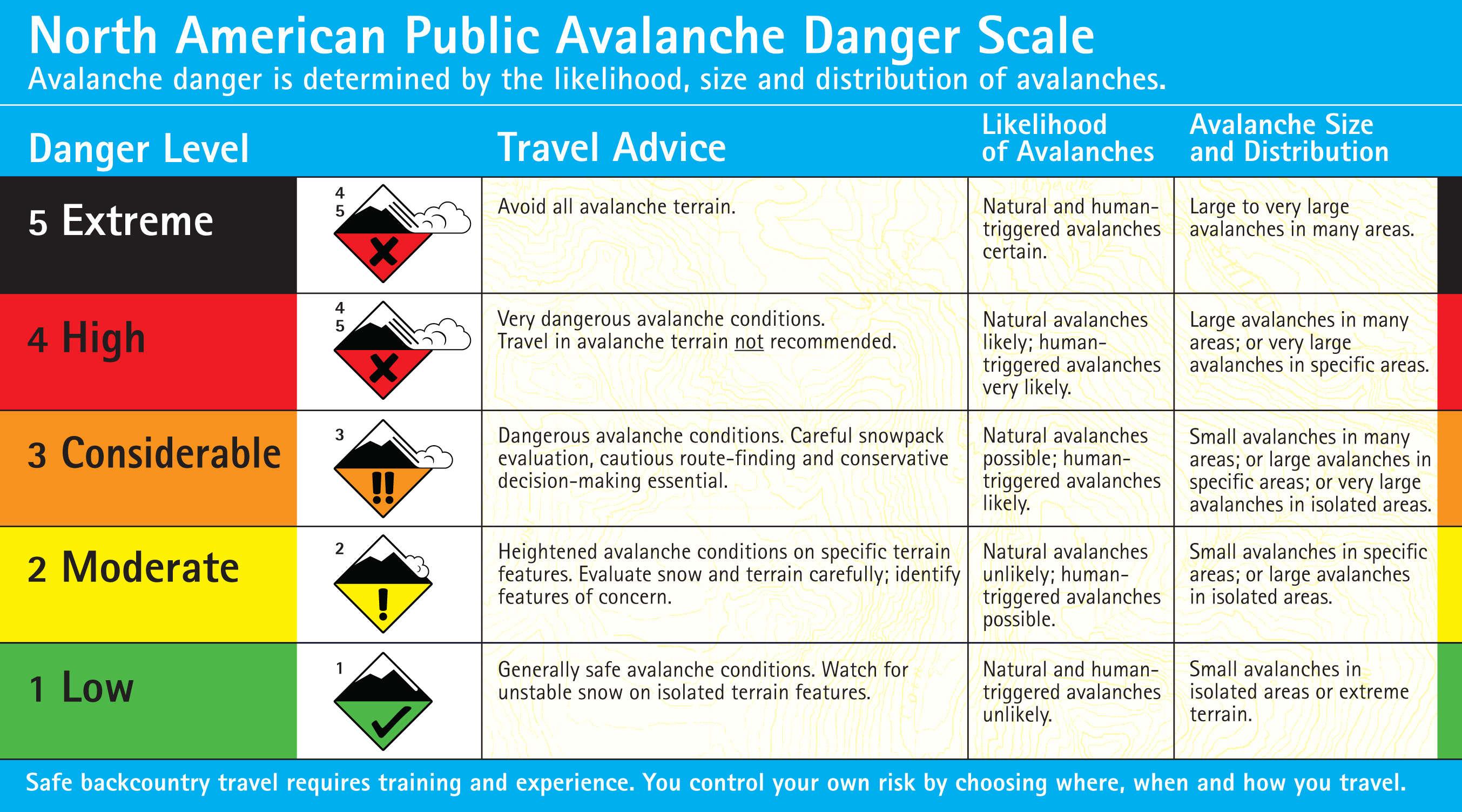
Today the avalanche danger is rated CONSIDERABLE. This means dangerous avalanche conditions exist, requiring careful snowpack evaluation, cautious route-finding and conservative decision making. See the complete danger scale here.
The northern Madison Range:
The mountains around Big Sky are caught between the more unstable conditions of the Bridger Range and southern mountains. Yesterday my partner and I toured into Beehive Basin and felt comfortable on slopes less than 35 degrees. However, unstable results during stability tests on multiple layers in the snowpack kept our decision making conservative (photo).
With multiple persistent weak layers being capped by a cohesive slab 1-3 feet thick, human triggered avalanches remain likely on slopes steeper than 35 degrees where the avalanche danger is rated CONSIDERABLE. Slopes less than 35 degrees have aMODERATE avalanche danger.
The northern Gallatin Range:
Stability is better in the northern Gallatin Range. On Wednesday, my partners and I skied in Hyalite Canyon where we found facets near the ground in our snowpits but it took heavy force to make these facets reactive in stability tests. We also witnessed evidence of a sizeable cornice that broke and hit the slope below but did not trigger an avalanche.
Certain areas of the northern Gallatin Range have a layer of buried surface hoar, which Mark found on Mt Ellis. After discovering this layer, he opted not to ski steeper terrain.
The most likely areas to trigger a slide in the northern Gallatin Range will be in steep or rocky terrain where the snowpack is thinner. For today human triggered avalanches are possible and the avalanche danger is MODERATE.
I will issue the next advisory tomorrow morning at 7:30 a.m. If you have any snowpack or avalanche observations, drop us a line at mtavalanche@gmail.com or call us at 587-6984.
EVENTS/EDUCATION
To check out all our education programs: http://www.mtavalanche.com/workshops/calendar
BOZEMAN
Snowmobiler Introduction to Avalanches with Field Course. Lectures on Saturday, January 7, with an all day field session Sunday, January 8. Advanced registration IS REQUIRED.
1-hr Avalanche Awareness Lecture. Wednesday, January 11, 6:30-7:30 p.m. at REI.
20/20 Hindsight - Lessons from recent accidents. Tuesday, January 17th, 6:30-7:30 p.m. at Montana Import Group
BIG TIMBER
1-hr Avalanche Awareness Lecture. Tuesday, January 10, 7-8 p.m. at Big Timber High School.
HELENA
1-hr Avalanche Awareness Lecture. This class has been rescheduled for Tuesday, January 31st.
COOKE CITY
1-hr Avalanche Awareness Lecture. Saturday, January 14, 5-6:00 p.m. at Cooke City Community Center.
CODY, WYOMING
Snowmobiler Introduction to Avalanches with Field Course. Lectures on Saturday, January 14 at Mountain Valley Motorsports with an all day field session near Cooke City on Sunday, January 15. Advanced registration IS REQUIRED.
BILLINGS
Snowmobiler Introduction to Avalanches with Field Course. Lectures on Tuesday, January 24 from 6-9 p.m. at Hi-Tech Motor Sports with an all day field session in Cooke City on Sunday, Jan 29. PRE-REGISTER BY JAN 23 at Hi-Tech!! Register with Sharon at 406-652-0090; hitech@hi-techmotorsports.com.
Great Falls
1-hr Avalanche Awareness Lecture Thursday, January 19th, 7-8 pm at Greenup Performance