Good morning. This is Doug Chabot with early season weather and avalanche information for the Gallatin National Forest Avalanche Center on Sunday, November 5th at 7:00 a.m. This bulletin is sponsored by The Friends of the Avalanche Center and World Boards. We will update early season information as conditions change.
Since yesterday morning an inch of new snow fell in the northern mountains, 6” around West Yellowstone and 10” outside Cooke City. Under partly cloudy skies mountain temperatures are in the upper teens and winds are southwest at 10-15 mph. Today will warm into the mid 20’s and clouds will increase with light W-SW winds. Snow is expected to fall later today and this evening bringing 3-5” in the southern mountains and 2-3” in the north. Dry, cold weather is forecasted Monday through Thursday with a possible shift back to snowy weather later in the week.

Since Wednesday the mountains have received 2-3’ of new snow with Cooke City getting over 4’. At the lower elevations this fell onto dirt while up high there was already 1-2’ on the ground. Most field observations indicate that the snow has good stability, a nice treat for early November. The exception are slopes that have been wind-loaded near the ridgetops. Avalanches were seen on Thursday on Mt. Blackmore (photo) and if winds increase, so will the avalanche danger.
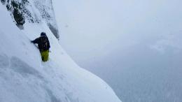
Skiers crawled all over the Bridger Range yesterday, mostly at Bridger Bowl. Eric and his partner joined the masses and observed, “We didn’t experience any cracking or collapsing and did not observe and recent activity. Overall stability was better than expected. I would guess on Saddle or the northern Bridgers things could be different where the wind had more influence.” His video explains the layering in the snowpack. Skiers on Mt Blackmore in Hyalite found similar conditions and in both ranges the winds were light. Climbers in Hyalite wallowed in new, powder snow down to the rock (photo) and only encountered sluffing.
It is early season and our understanding of the stability is limited since our field data is scarce. Besides the typical early season hazards of rocks, tree stumps, and our own rusty skill sets, we still have to analyze snow stability and travel as though it’s mid-winter (i.e. only expose one at a time, carry rescue gear, test for stability, etc.). There’s no shortcut to safety.
If you get out and have any avalanche or snowpack observations to share, drop a line via our website, email (mtavalanche@gmail.com), phone (406-587-6984), or Instagram (#gnfacobs).
Get Avalanche Smart – Growing Up
The Friends of the Avalanche Center present the first of 4 short films promoting avalanche education. Ben Goertzen explains why it is important to take an avalanche class. VIDEO.
Upcoming Avalanche Education and Events
Billings
7 November, Avalanche Awareness, 6-7:30 p.m. at Basecamp, Billings
BUTTE
17 November, Avalanche Awareness, 6-7:30 p.m., Butte, MT
HELENA
7 November, Avalanche Awareness, 6-7:30 p.m. at Carroll College, Helena
18 November, Avalanche Awareness and Beacon Practice for Snowmobiles, 9 a.m. at Montana Boat Center, Helena
7 December, Avalanche Awareness, 6-7:30 p.m. at Basecamp, Helena
BOZEMAN
6 December, Avalanche Awareness, 6-7:30 p.m. at REI Bozeman
7 December, Avalanche Awareness and Beacon Practice, 6-8 p.m. at Beall Park, Bozeman
Nov. 29, 30 and Dec. 2, 3 or 9, Introduction to Avalanches w/ Field Day, Info and Register Here
Jan. 12 and 13, Companion Rescue Clinic, Info and Register
Jan. 17, 18 and 20 or 21, Introduction to Avalanches w/ Field Day, Info and Register Here
Jan. 24, 25 and 27, Advanced Avalanche Workshop w. Field Day, Info and Register Here
Feb. 9 and 10, Companion Rescue Clinic, Info and Register
COOKE CITY
24 and 25 November, Current Conditions and Avalanche Rescue, 6:30-7:30 p.m. Friday and anytime between 10-2 on Saturday.