Good morning. This is Doug Chabot with early season weather and avalanche information for the Gallatin National Forest Avalanche Center on Monday, November 6th at 6:30 a.m. This information is sponsored by The Friends of the Avalanche Center and Community Food Co-op. We will update this bulletin when conditions change.
In the last 24 hours the mountains around Cooke City recorded 4” of new snow with 1-3” falling everywhere else. At 5 a.m. it is still snowing lightly and ridgetop winds are blowing W-SW at 15-20 mph and gusting to 30 mph with temperatures in the upper teens. Another inch will fall this morning, then skies will clear and temperatures will drop tonight to below 0F. Through Wednesday, skies will be mostly clear and temperatures will fluctuate between zero at night and teens during the day with light westerly winds. A weak storm might bring snow flurries Thursday and Friday.

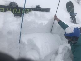
It sure looks like winter out there! There’s 2-4 feet of snow in the mountains and people have been getting out skiing, including us. Reports from Cooke City, Hyalite and the Bridger Range are surprisingly similar: on slopes that have not been wind-loaded the stability is mostly good. The snow structure is mostly “right-side up” which means less dense, powdery snow is sitting atop denser, supportable snow. These snowpits graphically show this stable structure (snowpit1, snowpit2).
Wind-loaded slopes are not stable. Evidence of this instability are recent avalanches near Fairy Lake (photo), Saddle Peak (photo) and Hyalite Peak. Even though wind speeds have not been strong, speeds of 15 mph are more than enough to blow and drift snow into unstable wind slabs.
Alex, Eric and I have been in the Bridger and northern Gallatin Ranges the last three days and are in agreement that slopes untouched by the wind are generally stable, but those near the ridgetops are suspect (video). Wind will be the primary factor creating unstable conditions in the coming days.
We will begin issuing daily avalanche advisories and danger ratings when the mountains get more snow. Our field data is currently limited. Besides our own field days we rely on others to help us form a picture of what’s happening across our forecast area. If you get out and have any avalanche or snowpack observations to share, drop a line via our website, email (mtavalanche@gmail.com), phone (406-587-6984), or Instagram (#gnfacobs).
Get Avalanche Smart – Growing Up
The Friends of the Avalanche Center present the first of 4 short films promoting avalanche education. Ben Goertzen explains why it is important to take an avalanche class. VIDEO.
Upcoming Avalanche Education and Events
BILLINGS
7 November, Avalanche Awareness, 6-7:30 p.m. at Basecamp, Billings
BUTTE
17 November, Avalanche Awareness, 6-7:30 p.m., Butte, MT
HELENA
7 November, Avalanche Awareness, 6-7:30 p.m. at Carroll College, Helena
18 November, Avalanche Awareness and Beacon Practice for Snowmobiles, 9 a.m. at Montana Boat Center, Helena
7 December, Avalanche Awareness, 6-7:30 p.m. at Basecamp, Helena
BOZEMAN
6 December, Avalanche Awareness, 6-7:30 p.m. at REI Bozeman
7 December, Avalanche Awareness and Beacon Practice, 6-8 p.m. at Beall Park, Bozeman
Nov. 29, 30 and Dec. 2, 3 or 9, Introduction to Avalanches w/ Field Day, Info and Register Here
The best $30 you’ll ever spend, guaranteed: Our Intro to Avalanches with Field Day. Two evenings of lectures plus a full day in the field digging pits and learning about rescue. https://events.ticketprinting.com/event/24613