Good Morning. This is Doug Chabot with the Gallatin National Forest Avalanche Advisory issued on Wednesday, December 13th at 6:45 a.m. Today’s advisory is sponsored by Mystery Ranch and Community Food Co-op. This advisory does not apply to operating ski areas.
At 5 a.m. under clear skies there’s no new snow, mountain temperatures are in the mid-20s and winds are blowing W-NW at 20-30 mph. It’s been eight days since snow fell in the northern ranges and five days in the south, but that’s about to change. A fast moving snow storm around noon will freshen up the mountains with 2-3” of snow by tonight. Winds will remain out of the W-NW at 20 mph with gusts of 40 mph during the storm. Clear weather returns tomorrow with more snow showers on Friday.

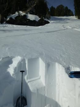
The snowpack is generally stable and the last reported avalanches were on Friday when ski patrols triggered small wind slabs. The backcountry only had a few wet sluffs on south-facing slopes. The snow depth varies from 5-6’ around Cooke City to 2.5’ in the northern mountains with all ranges harboring an ice crust that formed during Thanksgiving. In the absence of obvious signs of instability (cracking, collapsing or avalanches) we recommend digging and testing to this ice layer as a final step before dropping into avalanche terrain (photo, video). On Monday in Hyalite my partner and I found stable conditions on the approach to Divide Peak and also in our snowpit (profile).
If today’s storm arrives as expected, backcountry skiing and riding will improve but there will be a price to pay in the form of wind-loading and burying a new weak layer. A few inches of snow and wind may create 6-12” wind slabs at the ridgelines that could be triggered during and immediately after the storm. Additionally, the last 8 days of high pressure created a layer of small-grained facets (weak snow) at the surface which will get buried and cause avalanches in the future (photo). This layer is not widespread, but once buried it will require a bit of hunting to find. Stay tuned.
For today, the avalanche danger is starting out as LOW, but could rise with today’s snowfall.
If you get out and have any avalanche or snowpack observations to share, drop a line via our website, email (mtavalanche@gmail.com), phone (406-587-6984), or Instagram (#gnfacobs).
Upcoming Avalanche Education and Events
BOZEMAN
TONIGHT, Dec. 13, Avalanche Awareness, 6:30-8 p.m. at Gallatin Valley Snowmobile Association, 4-Corners
Dec. 21, Avalanche Awareness, 6-7:30 P.m. at Play It Again Sports, Bozeman
Jan. 12 and 13, Companion Rescue Clinic, Info and Register
Jan. 17, 18 and 20 or 21, Introduction to Avalanches w/ Field Day, Info and Register Here
Jan. 24, 25 and 27, Advanced Avalanche Workshop w. Field Day, Info and Register Here
Feb. 9 and 10, Companion Rescue Clinic, Info and Register
WEST YELLOWSTONE
Dec. 14 and 15, Snowmobiler Introduction to Avalanches with Field Course, Info and Register Here
Jan. 6, Avalanche Awareness, 7-8 p.m. at West Yellowstone Holiday Inn Conference Center
COOKE CITY
15 and 16 December, Weekly Current Conditions and Avalanche Rescue, 6:30-7:30 p.m. Friday @ the Super 8, and anytime between 10-2 on Saturday @ Lulu Pass road
A daily checklist is a great way to help prevent common mistakes or overlooking important data when travelling in the backcountry. This article from Backcountry Magazine discusses how to use and create your own backcountry checklist.
Normal 0 false false false false EN-US JA X-NONE /* Style Definitions */ table.MsoNormalTable {mso-style-name:"Table Normal"; mso-tstyle-rowband-size:0; mso-tstyle-colband-size:0; mso-style-noshow:yes; mso-style-priority:99; mso-style-parent:""; mso-padding-alt:0in 5.4pt 0in 5.4pt; mso-para-margin-top:0in; mso-para-margin-right:0in; mso-para-margin-bottom:10.0pt; mso-para-margin-left:0in; line-height:115%; mso-pagination:widow-orphan; font-size:11.0pt; font-family:"Calibri",sans-serif;}