Good Morning. This is Eric Knoff with the Gallatin National Forest Avalanche Advisory issued on Thursday, December 14th at 6:45 a.m. Today’s advisory is sponsored Alpine Orthopedics and Highline Partners. This advisory does not apply to operating ski areas.
Over the past 24 hours the mountains picked up 1-2” of new snow. At 5 a.m. snow has moved out of the region and skies have become partly cloudy. Temperatures are in the teens to low 20’s F and winds are blowing 10-20 mph out of the W-NW. Today, a weak ridge of high pressure builds over the area producing clear skies and fairly calm conditions. Temperatures will warm into the mid to upper 20’s and winds will remain light to moderate out of the W-NW. No snow is expected over the next 24 hours, but there will be an increasing chance of snow Friday night into Saturday.

Yesterday’s storm was unusual. The valleys picked up just as much snow as the mountains, if not more. Despite this fact, it was nice to see the white stuff fall. While this welcomed shot of snow improved skiing and riding conditions, it did little to heighten the avalanche danger.
Snow totals were 1-2”, which did not add a significant load to our snowpack. Today, there will be small isolated wind slabs near the ridgelines that formed from moderate west-northwest winds. These small slabs could be touchy if resting over a thin layer of near surface facets. However, these fresh slabs should only be 4-6” thick and pose little threat unless triggered in steep, high consequence terrain. Outside of small, isolated wind slabs the snowpack is generally stable (video).
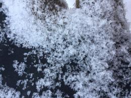
The main concern now is the layer of near surface facets that got capped by the new snow (photo). Yesterday, I found this layer to be well developed on the west side of the Bridger Range (video) and Doug found this layer in the Taylor Fork (photo). We do not have a complete record of where this layer exists, but it’s safe to say it can be found in all mountain ranges. Its distribution may be dependent on aspect and elevation and we’ll be tracking it as we spend more time in the field. Although this layer is not creating widespread instability at the moment, it will be something to pay close attention to as more snow falls this weekend.
Yesterday’s snowfall did not add significant stress to the snowpack. For this reason generally safe avalanche conditions exist and the avalanche danger is rated LOW.
If you get out and have any avalanche or snowpack observations to share, drop a line via our website, email (mtavalanche@gmail.com), phone (406-587-6984), or Instagram (#gnfacobs).
Upcoming Avalanche Education and Events
Events and Education Calendar
BOZEMAN
Dec. 21, Avalanche Awareness, 6-7:30 P.m. at Play It Again Sports, Bozeman
Jan. 12 and 13, Companion Rescue Clinic, Info and Register
Jan. 17, 18 and 20 or 21, Introduction to Avalanches w/ Field Day, Info and Register Here
Jan. 24, 25 and 27, Advanced Avalanche Workshop w. Field Day, Info and Register Here
Feb. 9 and 10, Companion Rescue Clinic, Info and Register
WEST YELLOWSTONE
Today and tomorrow, Snowmobiler Introduction to Avalanches with Field Course, Info and Register Here
Jan. 6, Avalanche Awareness, 7-8 p.m. at West Yellowstone Holiday Inn Conference Center
COOKE CITY
15 and 16 December, Weekly Current Conditions and Avalanche Rescue, 6:30-7:30 p.m. Friday @ the Super 8, and anytime between 10-2 on Saturday @ Lulu Pass road
A daily checklist is a great way to help prevent common mistakes or overlooking important data when travelling in the backcountry. This article from Backcountry Magazine discusses how to use and create your own backcountry checklist.