Good Morning. This is Doug Chabot with the Gallatin National Forest Avalanche Advisory issued on Wednesday, December 27th at 7:00 a.m. Today’s advisory is sponsored by Gallatin County Search and Rescue and Community Food Co-op. This advisory does not apply to operating ski areas.
In the last 24 hours 1-2” fell in the southern mountains and Cooke City. Under cloudy skies, ridgetop winds are SW at 20-35 mph and mountain temperatures are 10F. The next 3 days will be snowy with the heaviest amounts falling in the southern mountains. Winds will remain SW at 20-35 mph as temperatures reach 20F during the day and low teens at night. By tomorrow morning the mountains around Bozeman and Big Sky will have 2-4”, the southern ranges will have 4-6” and Cooke City 8-12”.

A southwest flow is bringing snow to Cooke City and the Lionhead area today. In the last week, 2-3’ of new snow outside Cooke City has been blown into wind drifts, with a few wind-loaded slopes triggered by skiers (photo, photo). On some slopes, underneath this new snow is a weak layer of unstable facets. Skiers on Christmas Day triggered a small soft slab avalanche on a SW facing slope below treeline on this layer (photo). Last Friday and Saturday Alex investigated the snowpack and outlined these concerns in his video, which is still relevant today.
In the Lionhead area, 2’ of snow in the past 7 days fell onto weak, sugary facets that are showing signs of instability (video). Forecasted snowfall and wind will make this layer reactive to human triggering.
Most avalanches occur during or immediately after a storm and the next few days will be unstable; wind-loaded slopes especially so. Turn around at the first signs of cracking or collapsing and be aware that recent avalanches are Mother Nature’s warning sign that nearby slopes are also unstable. For today, the avalanche danger is CONSIDERABLE on wind-loaded slopes and MODERATE on all others, but will rise to CONSIDERABLE on all slopes if/when the storm hits.

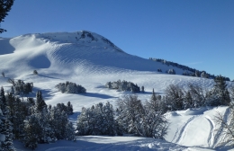
In the last week close to 2’ of snow fell in the Bridger, Gallatin and Madison Ranges. Strong ridgetop winds loaded slopes, but overall avalanche activity was minimal and the snowpack was strong enough to handle the new load, which Eric found last Thursday in Taylor Fork (video). Skiers up Mt. Blackmore yesterday only saw loose snow slides and found no deeper instabilities (photo). There are always exceptions, and on Sunday I found a thin layer of weak facets breaking in my stability tests (video) and I could see an avalanche far to the south on a wind-loaded slope (photo). These instabilities are isolated, but worth looking for. Dig 2-3’ deep to the prominent ice crust and test the snow because just one unstable slope would ruin your day.
Human triggered avalanches are possible today, most surely on wind-loaded slopes, but also on slopes that harbor a weak layer of facets 2’ under the new snow. The danger is rated MODERATE on all slopes today.
If you get out and have any avalanche or snowpack observations to share, drop a line via our website, email (mtavalanche@gmail.com), phone (406-587-6984), or Instagram (#gnfacobs).
Upcoming Avalanche Education and Events
BOZEMAN
Jan. 3, Avalanche Awareness, 6-7 p.m. at REI Bozeman
Jan. 12 and 13, Companion Rescue Clinic, Info and Register
Jan. 17, 18 and 20 or 21, Introduction to Avalanches w/ Field Day, Info and Register Here
Jan. 24, 25 and 27, Advanced Avalanche Workshop w. Field Day, Info and Register Here
Feb. 9 and 10, Companion Rescue Clinic, Info and Register
WEST YELLOWSTONE
Jan. 6, Avalanche Awareness, 7-8 p.m. at West Yellowstone Holiday Inn Conference Center
BIG TIMBER
Jan. 11, Avalanche Awareness, 6-7 p.m. at Sweet Grass County High School
BUTTE
Jan. 13, Rescue Clinic, 10 a.m. at Homestake Lodge
Dillon
Jan. 16, Avalanche Awareness, 6:30-8 p.m. at U.M. Western Library
COOKE CITY
Every Friday and Saturday, Current Conditions Update and Avalanche Rescue, Friday 6:30-7:30 p.m. at Super 8 this week, and Antler's Lodge in January. Saturday anytime between 10-2 @ Lulu Pass road.
Drew Hardesty of the Utah Avalanche Center looks back on a crazy day of avalanches on Nov 13, 2011 in their first UAC Podcast – The Day of Madness in Little Cottonwood Canyon.