Good Morning. This is Eric Knoff with the Gallatin National Forest Avalanche Advisory issued on Thursday, December 28th at 7:00 a.m. Today’s advisory is sponsored The Knoff Group Real Estate @ Pure West and Yellowstone Ski Tours. This advisory does not apply to operating ski areas.
Over the past 24 hours the mountains around Cooke City picked up 12-15” of new snow. The mountains around Bozeman and Big Sky received 3-5” while the West Yellowstone area received 1-2”. Currently, temps are in the teens F and winds are blowing 20-40 mph out of the west with gusts in Hyalite and Big Sky breaking 50 mph. Today, temps will warm into the upper teens to low 20’s F and moderate to strong winds will continue out of the west. Snow will continue around Cooke City where an additional 6-8” will fall by tomorrow morning. The rest of the advisory area will see light snow showers today and tonight. Most areas will see 2-4” by tomorrow morning.

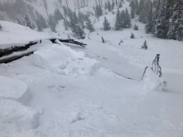
The equation is simple around Cooke City today. Heavy snow and strong winds are creating very dangerous avalanche conditions. Over the past 24 hours, Fisher Creek Snotel site has received close to a foot of snow totaling 1” of SWE. Snow amounts are higher at upper elevations. Yesterday, a skier got cracking and collapsing on lower elevation slopes near town. Skiers also triggered a few small avalanches a couple of days ago (photo, photo). These are obvious signs the snowpack is having trouble adjusting to the heavy load.
Today, continued snow and wind will create a perfect recipe for avalanches. All wind loaded slopes and avalanche run out zones should be avoided. Steeper, non-wind loaded slopes should be evaluated carefully and approached with caution.
Today, natural and human triggered avalanches are likely on wind loaded slopes which have a HIGH avalanche Danger. Non-wind loaded slopes have CONSIDERABLE avalanche danger.

Wind is the dominating factor in the mountains around Bozeman, Big Sky and West Yellowstone. Overnight, winds blew 20-40 mph out of the west, with gusts around Hyalite and Big Sky breaking 50 mph. These strong winds combined with 3-5” of new snow will make wind slabs today’s primary avalanche concern.
Thick, dense slabs will be most likely below upper elevation ridgelines leeward to west winds (photo). These slabs will be 1-3’ thick and will easily fail under the weight of a skier and rider. Wind slabs will also be found on the leeward side of cross loaded terrain features on mid to low elevation slopes. Yesterday, skiers on Mt Blackmore in the northern Gallatin Range observed active wind transport in the bowl well below the summit. Today, avoiding wind loaded slopes will be the best way to avoid avalanches.
In addition to wind loaded slopes, a layer of facets buried 2-3’ remains a concern. This layer is most widespread in the mountains around West Yellowstone, but has sporadic distribution across the advisory area (video, video). Yesterday, a snowmobiler driving over Targhee Pass observed a recent slide on a small slope just off the road. Small slides are key indicators that larger slides are possible. It’s worth digging 2-3’ feet deep to assess this layer of facets before committing to steeper terrain.
Today, human triggered avalanches are likely on wind loaded slopes which have a CONSIDERABLE avalanche danger. Non-wind loaded slopes have a MODERATE avalanche danger.
If you get out and have any avalanche or snowpack observations to share, drop a line via our website, email (mtavalanche@gmail.com), phone (406-587-6984), or Instagram (#gnfacobs).
Upcoming Avalanche Education and Events
BOZEMAN
Jan. 3, Avalanche Awareness, 6-7 p.m. at REI Bozeman
Jan. 12 and 13, Companion Rescue Clinic, Info and Register
Jan. 17, 18 and 20 or 21, Introduction to Avalanches w/ Field Day, Info and Register Here
Jan. 24, 25 and 27, Advanced Avalanche Workshop w. Field Day, Info and Register Here
Feb. 9 and 10, Companion Rescue Clinic, Info and Register
WEST YELLOWSTONE
Jan. 6, Avalanche Awareness, 7-8 p.m. at West Yellowstone Holiday Inn Conference Center
BIG TIMBER
Jan. 11, Avalanche Awareness, 6-7 p.m. at Sweet Grass County High School
BUTTE
Jan. 13, Rescue Clinic, 10 a.m. at Homestake Lodge
Dillon
Jan. 16, Avalanche Awareness, 6:30-8 p.m. at U.M. Western Library
COOKE CITY
Every Friday and Saturday, Current Conditions Update and Avalanche Rescue, Friday 6:30-7:30 p.m. at Super 8 this week, and Antler's Lodge in January. Saturday anytime between 10-2 @ Lulu Pass road.
Drew Hardesty of the Utah Avalanche Center looks back on a crazy day of avalanches on Nov 13, 2011 in their first UAC Podcast – The Day of Madness in Little Cottonwood Canyon.