Good Morning. This is Eric Knoff with the Gallatin National Forest Avalanche Advisory issued on Friday, December 29th at 7:00 a.m. Today’s advisory is sponsored by Highline Partners and Cooke City Motor Sports. This advisory does not apply to operating ski areas.
Cooke City remains in the cross hairs of a major winter storm. Over the past 24 hours, Fisher Creek Snotel Site has received 12” of new snow with higher amounts likely at upper elevations. The mountains around Bozeman, Big Sky and West Yellowstone have picked up 2-4” over the past 24 hours. At 5 a.m. temps are in the teens to mid-20’s F and winds are blowing 20-40 mph out of the west with ridgetop gusts pushing 50 mph. Today, snow will continue across the advisory area. The mountains around Cooke City will see 6-8” during the day and another 6-8” tonight. The mountains around Bozeman, Big Sky and West Yellowstone will see 2-4” today with an additional 6-8” tonight.

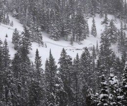
Over the past three days the mountains around Cooke City have received nearly three feet of snow totaling 2.5” of SWE. This rapid and heavy load has put a tremendous amount of stress on the snowpack, which is creating very dangerous avalanche conditions. Yesterday, a person was partially buried up Sheep Creek outside of Cooke City. The slide broke 2’ deep, 200’ wide and occurred on a south-southwest facing slope. Details are vague, but it sounds like he was uninjured. This slide is consistent with other observations from the area. Natural avalanches were also observed yesterday on mid-elevation, south-facing slopes (photo, photo, photo).
Slides appear to be failing on a layer of facets buried 2-3’ deep, which are sitting on top of the Thanksgiving ice crust. This problem does not exist on all slopes, and seems to be mostly confined to slopes with a southerly aspect. As new and wind-blown snow add stress to this layer, it will continue to be problematic.
Slopes do not need to harbor a buried persistent weak layer in order to produce avalanches. With continued snow and wind today, natural and human triggered avalanches will be likely on all wind loaded slopes which have a HIGH avalanche danger. Non-wind loaded slops have a CONSIDERABLE avalanche danger.

The snowpack in the Lionhead area near West Yellowstone has a weak structure. Facets buried 2-3’ feet exist on all aspects and elevations. This persistent weak layer has been pushed to its breaking point by recent snow and wind. Yesterday, Doug and his partner observed numerous avalanches while riding around the area (video, photo). Under these conditions, avalanches have the ability to be triggered remotely. This means you can trigger an entire slope from flat or low angle terrain. Today, careful snowpack evaluation and terrain management will be essential.
As the snowpack continues to be stressed by new and wind-blown snow, human triggered avalanches will be likely on all slopes and the avalanche danger is rated CONSIDERABLE. If the storm hits harder than expected today, the avalanche danger could rise to HIGH on all slopes.
A mostly stable snowpack in the mountains around Bozeman and Big Sky has kept avalanche activity to a minimum. Yesterday, I toured on the west side of the Bridgers and was pleasantly surprised by the overall stability. Facets near the Thanksgiving ice crust weren’t breaking in stability tests and we did not observe any recent avalanche activity (video). These observations are consistent with other reports from the area.
As the next storm settles in, new snow instabilities will be the main concern. Wind slabs and storm slabs will grow in size and distribution as the storm progresses. Watch for cracking/collapsing in the new snow and avoid steeper slopes where signs of instability are present.
Today, snow and wind will make human triggered avalanches likely on wind loaded slopes which have CONSIDERABLE avalanche danger. Non-wind loaded slopes have MODERATE avalanche danger.
If you get out and have any avalanche or snowpack observations to share, drop a line via our website, email (mtavalanche@gmail.com), phone (406-587-6984), or Instagram (#gnfacobs).
Upcoming Avalanche Education and Events
BOZEMAN
Jan. 3, Avalanche Awareness, 6-7 p.m. at REI Bozeman
Jan. 12 and 13, Companion Rescue Clinic, Info and Register
Jan. 17, 18 and 20 or 21, Introduction to Avalanches w/ Field Day, Info and Register Here
Jan. 24, 25 and 27, Advanced Avalanche Workshop w. Field Day, Info and Register Here
Feb. 9 and 10, Companion Rescue Clinic, Info and Register
WEST YELLOWSTONE
Jan. 6, Avalanche Awareness, 7-8 p.m. at West Yellowstone Holiday Inn Conference Center
BIG TIMBER
Jan. 11, Avalanche Awareness, 6-7 p.m. at Sweet Grass County High School
BUTTE
Jan. 13, Rescue Clinic, 10 a.m. at Homestake Lodge
Dillon
Jan. 16, Avalanche Awareness, 6:30-8 p.m. at U.M. Western Library
COOKE CITY
Every Friday and Saturday, Current Conditions Update and Avalanche Rescue, Friday 6:30-7:30 p.m. at Super 8 this week, and Antler's Lodge in January. Saturday anytime between 10-2 @ Lulu Pass road.
Drew Hardesty of the Utah Avalanche Center looks back on a crazy day of avalanches on Nov 13, 2011 in their first UAC Podcast – The Day of Madness in Little Cottonwood Canyon.