Good Morning and Happy New Year. This is Alex Marienthal with the Gallatin National Forest Avalanche Advisory issued on Monday, January 1st, 2018 at 7:15 a.m. Today’s advisory is sponsored by Yellowstone Arctic Yamaha and Yamaha Motor Corp in partnership with the Friends of the Avalanche Center. This advisory does not apply to operating ski areas.
The mountains did not get any new snow in the past 24 hours. Temperatures this morning are teens F and wind is west-southwest at 10-20 mph with gusts of 25-30 mph. Near Cooke City, wind is west-northwest at 5-10 mph. Under mostly clear skies today, temperatures will be high teens to low 20s F with west-northwest wind at 15-25 mph.

Near Cooke City the snowpack is 5-8 feet deep, and near West Yellowstone and south of Big Sky it is 3-6 feet deep. The multi-day storm that ended Saturday dropped over 4 feet of snow equal to 4” of snow water equivalent (SWE) near Cooke City, 1-2 feet of snow equal to 1-2” of SWE in the southern Madison and Gallatin ranges, and a foot of snow equal to .6” SWE near West Yellowstone.
Prior to and during the avalanche warning on Saturday, widespread avalanche activity was observed near Cooke City, Bacon Rind, Tepee Creek, and the Lionhead area. See our photos page for a look at recent activity, or our weather and avalanche log for a quick summary.
Today, avalanches are easy to trigger where the snowpack is relatively shallow, such as lower elevations and southerly aspects, or most slopes in the Lionhead area (video, photo, photo). Yesterday, skiers near Hebgen Lake reported widespread collapsing and cracking, and similar findings were reported near Cooke City. This is bullseye data that weak facets 2-4’ deep can produce avalanches (video, photo, video). Avoid steep slopes in areas where the snowpack is relatively shallow, or if you see cracking and collapsing.
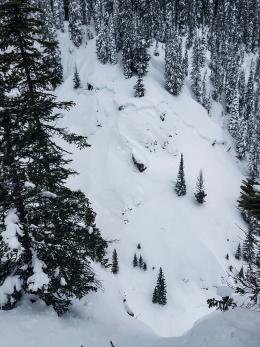
Large wind slabs that linger from the recent storm are possible to trigger near ridgelines and near the edges or base of cliffs (photo, photo). Moderate wind today will form small, fresh slabs near ridgelines that are easy to trigger, but pose minimal threat.
Avalanches are easy to trigger on weak facets where the snowpack is relatively shallow, and avalanche danger today is CONSIDERABLE.

It has been two days since the mountains received any new snow, winds are light to moderate, and the snowpack has had time to adjust to the recent storm. Near Bozeman and Big Sky the snowpack is 3-6 feet deep, and the recent storm dropped 2-3 feet of snow equal to 2-3” of SWE. On Friday, a skier was caught and injured in Truman Gulch on the west side of the Bridger Range (video, photo). The slide broke 2 feet deep on old, weak faceted snow. This instability is not widespread near Bozeman and Big Sky, but this avalanche shows that large avalanches are possible on some slopes. Carefully evaluate the snowpack before riding in steep terrain.
Moderate wind today will drift snow into small, fresh slabs near ridgelines that are easy to trigger. These small slabs pose little hazard unless they push you through trees, rocks, or over cliffs. Assess the terrain for consequences of being caught in even a small slide.
Today, the avalanche danger is rated MODERATE.
If you get out and have any avalanche or snowpack observations to share, drop a line via our website, email (mtavalanche@gmail.com), phone (406-587-6984), or Instagram (#gnfacobs).
Upcoming Avalanche Education and Events
BOZEMAN
Jan. 3, Avalanche Awareness, 6-7 p.m. at REI Bozeman
Jan. 12 and 13, Companion Rescue Clinic, Info and Register
Jan. 17, 18 and 20 or 21, Introduction to Avalanches w/ Field Day, Info and Register Here
Jan. 24, 25 and 27, Advanced Avalanche Workshop w. Field Day, Info and Register Here
Feb. 9 and 10, Companion Rescue Clinic, Info and Register
WEST YELLOWSTONE
Jan. 6, Avalanche Awareness, 7-8 p.m. at West Yellowstone Holiday Inn Conference Center
BIG TIMBER
Jan. 11, Avalanche Awareness, 6-7 p.m. at Sweet Grass County High School
BUTTE
Jan. 13, Rescue Clinic, 10 a.m. at Homestake Lodge
Dillon
Jan. 16, Avalanche Awareness, 6:30-8 p.m. at U.M. Western Library
COOKE CITY
Every Friday and Saturday, Current Conditions Update and Avalanche Rescue, Friday 6:30-7:30 p.m. at The Antler's Lodge in January. Saturday anytime between 10-2 @ Lulu Pass road.
Saturday's Avalanche Warning is only a day expired. Clear skies and fresh snow will make for great riding conditions today, but avalanches are still easy to trigger in the southern Ranges. Give steep slopes time to adjust to the recent heavy load, and enjoy low angle powder.