Good Morning. This is Doug Chabot with the Gallatin National Forest Avalanche Advisory issued on Wednesday, January 10th at 7:00 a.m. Today’s advisory is sponsored by Montana State Parks and Gallatin County Search and Rescue. This advisory does not apply to operating ski areas.
AVALANCHE WARNING
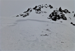
The Gallatin National Forest Avalanche Center is issuing a Backcountry Avalanche Warning for the Lionhead area outside West Yellowstone. Over a foot of heavy, dense snow has fallen onto a weak and unstable snowpack. Dangerous avalanche conditions exist on all slopes and the backcountry has a HIGH avalanche danger. Natural and human triggered avalanches are likely. Avalanche terrain and avalanche runout zones should be avoided.
At 5 a.m. Cooke City, Lionhead and the Yellowstone Club have 10-12” of new snow, while other areas have 6-7”, except Hyalite, which is has 2”. Another 3-6” will fall before the storm dissipates mid-morning. Mountain temperatures are in the mid to high 20’s, but below freezing (rain) in some valleys. Winds are averaging 20 mph with gusts of 30-40 mph out of the SW-W. Winds will decrease and shift westerly when the storm ends.

Avalanche Warning
The Lionhead area outside West Yellowstone received a foot of dense snow measuring 1.2” of snow water equivalent (SWE) in the last 12 hours. This is a heavy and rapid load that fell onto a weak and unstable snowpack. Two days ago skiers reported widespread collapsing and cracking, and yesterday Eric and I got poor test results in our snowpits (video, photo). Today’s snowfall has created dangerous avalanche conditions on all slopes for all users: skiers, snowmobilers, snow shoers, the avalanches do not care. People will easily trigger avalanches from the bottom of slopes on flat terrain. You do not need to be on the slope to trigger it. Many people have died in similar conditions, so to be safe, give all slopes a wide berth. The avalanche danger is rated HIGH and traveling in the backcountry is serious and risky.
This morning it is still snowing and the winds are blowing SW-W at the ridgelines. I am unclear on the exact amount of snow that has fallen because above freezing temperatures at some lower elevation SNOTEL sites are recording lots of water, but not much snow. For example, Brackett Creek in the Bridger Range has 1.3” of SWE but reading only 5” of snow. I can only assume the higher elevations have a lot more snow and elevated avalanche danger.
Today is a day to be conservative. Most avalanches occur during and immediately after a storm, and today is no exception. An inch or more of SWE in 12 hours is a lot of weight and the snowpack will struggle to handle it. Some avalanches will occur at the interface of yesterday’s snow surface, others may break 2-4’ deep on a layer of facets. My advice is to be wary of avalanche terrain and be especially mindful traveling underneath ridgelines where wind-loaded slopes could avalanche naturally. The avalanche danger is rated HIGH on all wind-loaded slopes and CONSIDERABLE on all other terrain.

The SNOTEL at Shower Falls in Hyalite is showing 2” of new snow (.2” SWE) with wind gusting to 40 mph out of the west on Flanders Mountain. The avalanche concern is with this new wind-blown snow since these drifts will be easy to trigger. The underlying snowpack is generally stable and although higher elevations may have 4+” of new snow I do not expect avalanches to break into older layers. For today, the avalanche danger is rated CONSIDERABLE on all wind-loaded terrain and MODERATE on all other slopes.
If you get out and have any avalanche or snowpack observations to share, drop a line via our website, email (mtavalanche@gmail.com), phone (406-587-6984), or Instagram (#gnfacobs).
Upcoming Avalanche Education and Events
BOZEMAN
Jan. 12 and 13, Companion Rescue Clinic, Info and Register
Jan. 15, Avalanche Awareness, 6-7 p.m. at Yellowstone Motorsports
Jan. 17, 18 and 20 or 21, Introduction to Avalanches w/ Field Day, Info and Register Here
Jan. 24, 25 and 27, Advanced Avalanche Workshop w. Field Day, Info and Register Here
Feb. 9 and 10, Companion Rescue Clinic, Info and Register
WEST YELLOWSTONE
Jan. 20, Avalanche Awareness, 7-8 p.m. at West Yellowstone Holiday Inn Conference Center
BIG TIMBER
Jan. 11, Avalanche Awareness, 6-7 p.m. at Sweet Grass County High School
BUTTE
Jan. 13, Rescue Clinic, 10 a.m. at Homestake Lodge
Dillon
Jan. 16, Avalanche Awareness, 6:30-8 p.m. at U.M. Western Library
COOKE CITY
Every Friday and Saturday, Current Conditions Update and Avalanche Rescue, Friday 6:30-7:30 p.m. at The Antler's Lodge in January. Saturday anytime between 10-2 @ Round Lake.
Here is a powerful and moving interview with Lesley Martin about her 105 minute burial in Frenchman Creek, Idaho on February 16, 2014, which killed her husband, George. Video: https://vimeo.com/channels/mountainoutlaw/245046506