Good Morning. This is Eric Knoff with the Gallatin National Forest Avalanche Advisory issued on Thursday, January 11th at 7:00 a.m. Today’s advisory is sponsored by Mystery Ranch and Montana Ale Works. This advisory does not apply to operating ski areas.
Since yesterday morning, most mountain locations picked up 6-10” of new snow. Snow tapered off overnight and currently no snow is falling in the advisory area. At 5 a.m. temperatures range from the single digits to mid-teens F and winds are blowing 15-30 mph out of the W-SW. Today, temps will warm into the mid to upper 20’s F and winds will increase with gust upwards of 40 mph. Snow develops during the afternoon hours and continues overnight. The mountains south of Bozeman will pick up 6-8” by tomorrow morning while the northern ranges will see 4-6”.

A snowmobiler from Idaho Falls is missing and presumed dead near Reas Peak on the Caribou-Targhee National Forest in the Centennial Range. His snowmobile was found partially buried in avalanche debris but he is unaccounted for. The rescue will continue today. Read a short clip from the East Idaho News here. We will update this post as more information becomes available.
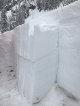
Although the Centennial Range is out of our forecast area, it has a similar snowpack structure to the Lionhead area and mountains around West Yellowstone. The southern mountains have received a heavy amount of snow over the past 36 hours and the snowpack remains under a tremendous amount of stress. Facets buried 2-4’ deep are the primary concern and slides failing on this layer will be large and dangerous (video, photo, photo). It will be possible to trigger entire slopes from the bottom or from a distance and travel in avalanche terrain is not recommend.
As more snow and wind impact the area today, very dangerous avalanched conditions exist. Natural and human triggered avalanches will be likely on wind loaded slopes which have a HIGH avalanche danger. Human triggered avalanches are likely on non-wind loaded slopes which have a CONSIDERABLE avalanche danger.

Over the past day and a half, the mountains around Bozeman, Big Sky and Cooke City picked up 12 to 16” of snow totaling 1 to 1.5” of SWE. The snowpack in these areas is stronger than the mountains around West Yellowstone and was able to handle the recent load better. Yesterday, I skied in Beehive Basin near Big Sky and did not observe any signs of instability or recent avalanche activity. We found the new snow well bonded to the old surface and reluctant to move.
However, the Big Sky Ski Patrol actively triggered fresh winds slabs during control work yesterday morning. This problem seemed to be confined to terrain at or above treeline. Today, wind loaded slopes will be the primary avalanche concern. With more snow and wind in the forecast, wind slabs will grow in size and distribution as the day progresses. Watch for signs of instability such as cracking and collapsing and avoid steep slopes with wind drifted snow.
While most avalanches will stay confined within the storm snow, there is the possibility for slides to fail on facets buried 2-4’ deep. This instability is not widespread, but should be looked for and assessed before skiing or riding steeper slopes.
Today, human triggered avalanches are likely on wind loaded slopes which have a CONSIDERABLE avalanche danger. Non-wind loaded slopes have a MODERATE avalanche danger.
If you get out and have any avalanche or snowpack observations to share, drop a line via our website, email (mtavalanche@gmail.com), phone (406-587-6984), or Instagram (#gnfacobs).
King and Queen of the Ridge
King and Queen of the Ridge, Saturday, February 3rd. A Hike and Ski/Ride-a-Thon fundraising event to support the Friends of the Gallatin National Forest Avalanche Center. Sign up and start collecting pledges HERE.
Upcoming Avalanche Education and Events
BOZEMAN
Jan. 12 and 13, Companion Rescue Clinic, Info and Register
Jan. 15, Avalanche Awareness, 6-7 p.m. at Yellowstone Motorsports
Jan. 17, 18 and 20 or 21, Introduction to Avalanches w/ Field Day, Info and Register Here
Jan. 22, MAP Brewing Pint Night, 4-8 p.m. MAP donates 50 cents of every pint sold to the Friends of the Avalanche Center.
Jan. 24, 25 and 27, Advanced Avalanche Workshop w. Field Day, Info and Register Here
Feb. 9 and 10, Companion Rescue Clinic, Info and Register
WEST YELLOWSTONE
Jan. 20, Avalanche Awareness, 7-8 p.m. at West Yellowstone Holiday Inn Conference Center
BIG TIMBER
Jan. 11, Avalanche Awareness, 6-7 p.m. at Sweet Grass County High School
BUTTE
Jan. 13, Rescue Clinic, 10 a.m. at Homestake Lodge
Dillon
Jan. 16, Avalanche Awareness, 6:30-8 p.m. at U.M. Western Library
COOKE CITY
Every Friday and Saturday, Current Conditions Update and Avalanche Rescue, Friday 6:30-7:30 p.m. at The Antler's Lodge in January. Saturday anytime between 10-2 @ Round Lake.
Watch the new Dashboard Talks, Episode 3: Down in a Hole. You should dig snowpits and perform stability tests, but how many is enough? Well that depends... Doug and Eric discuss the relationship between your objectives and pit digging.