Good Morning. This is Eric Knoff with the Gallatin National Forest Avalanche Advisory issued on Friday, January 12th at 7:00 a.m. Today’s advisory is sponsored by The Knoff Group Real Estate @ Pure West and Bridger Bowl. This advisory does not apply to operating ski areas.
AVALANCHE WARNING
The Gallatin National Forest Avalanche Center is issuing a Backcountry Avalanche Warning for the Lionhead area outside West Yellowstone. Heavy snow has fallen onto a weak and unstable snowpack. Dangerous avalanche conditions exist and the avalanche danger is rated HIGH on all slopes. Natural and human triggered avalanches are likely. Avalanche terrain and avalanche runout zones should be avoided.
At 5 a.m. the mountains around West Yellowstone and Cooke City have 8-10” of new snow, while the mountains around Bozeman and Big Sky have 4-6”. Snow showers continue to linger in the mountains, but additional accumulation is not expected today. Currently, temps range from the teens to mid-20”s F and winds are blowing 20-40 out of the west. Today, skies will remain mostly cloudy and temps will warm into the mid to upper 20’s. Winds will decrease as the day progresses, but will continue to blow 10-25 mph out of the west. A weak ridge of high pressure builds over the region this evening producing generally dry conditions for the weekend.

Avalanche Warning
The Lionhead area outside of West Yellowstone picked up 8-10” of heavy snow overnight totaling .9” of SWE. This puts the three day total at over two feet of snow totaling 2.3” of SWE. The snowpack structure in this area is very weak and will be unable to support this heavy load (video, photo). Yesterday, a snowmobiler reported widespread cracking and collapsing while riding in this area (photo). People will easily trigger avalanches from the bottom of slopes on flat terrain. Today, natural and human triggered avalanches are likely and the avalanche danger is rated HIGH on all slopes.

The southern Madison and Gallatin Ranges and mountains around Cooke City have picked up 1.5 to 2’ of snow over the past three days totaling 1.5 to 2” of SWE. Fortunately, the snowpack in these areas is a bit stronger than the Lionhead area. Yesterday, Doug skied at Bacon Rind in the southern Madison Range and was pleasantly surprised by the strength of the snowpack (photo, video). Skiers outside of Cooke City also noted the snowpack is handling the recent load surprisingly well.
With that said, facets buried 2-4’ deep remain a concern. This layer is stronger than it was a few weeks ago, but could easily become more reactive with the additional weight of new and wind-blown snow. Since the loading event just ended a few hours ago, I would be extra cautious when traveling in avalanche terrain today. Wind loaded slope will be the most prone to producing avalanches, but non-wind loaded slopes also hold the potential to produce large slides.
For this reason, the avalanche danger is rated CONSIDERABLE on all slopes.
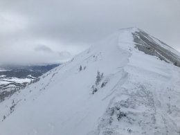
The mountains near Bozeman and Big Sky have a stronger snowpack than the southern ranges. These areas also picked up less snow over the past 24 hours. Today, the primary concern in the mountains around Bozeman and Big Sky will be wind slabs. The combination of 4-6” of new snow and strong westerly winds will form dense slabs below ridgelines and on the leeward side of crossloaded terrain features. Yesterday, natural avalanches were observed on Saddle Peak south of Bridger Bowl (photo). These slides were the direct result of heavy wind loading. Today, fresh wind slabs will be touchy to human triggers and pose the greatest threat in steeper high consequence terrain.
There’s still the possibility for slides to break on facets buried 2-4’ deep. It has been a while since slides have failed on this layer, but it can’t be entire ruled out. This problem seems to be more confined to areas with a shallow snowpack. Keep this in mind when traveling on mid to low elevations slopes or areas where the snowpack depth is highly variable.
Today, the avalanche danger is rated CONSIDERABLE on wind loaded slopes and MODERATE on non-wind loaded slopes.
If you get out and have any avalanche or snowpack observations to share, drop a line via our website, email (mtavalanche@gmail.com), phone (406-587-6984), or Instagram (#gnfacobs).
King and Queen of the Ridge
King and Queen of the Ridge, Saturday, February 3rd. A Hike and Ski/Ride-a-Thon fundraising event to support the Friends of the Gallatin National Forest Avalanche Center. Sign up and start collecting pledges HERE.
Upcoming Avalanche Education and Events
BOZEMAN
Jan. 12 and 13, Companion Rescue Clinic, Info and Register
Jan. 15, Avalanche Awareness, 6-7 p.m. at Yellowstone Motorsports
Jan. 17, 18 and 20 or 21, Introduction to Avalanches w/ Field Day, Info and Register Here
Jan. 22, MAP Brewing Pint Night, 4-8 p.m. MAP donates 50 cents of every pint sold to the Friends of the Avalanche Center.
Jan. 24, 25 and 27, Advanced Avalanche Workshop w. Field Day, Info and Register Here
Feb. 9 and 10, Companion Rescue Clinic, Info and Register
WEST YELLOWSTONE
Jan. 20, Avalanche Awareness, 7-8 p.m. at West Yellowstone Holiday Inn Conference Center
BIG TIMBER
Jan. 11, Avalanche Awareness, 6-7 p.m. at Sweet Grass County High School
BUTTE
Jan. 13, Rescue Clinic, 10 a.m. at Homestake Lodge
Dillon
Jan. 16, Avalanche Awareness, 6:30-8 p.m. at U.M. Western Library
COOKE CITY
Every Friday and Saturday, Current Conditions Update and Avalanche Rescue, Friday 6:30-7:30 p.m. at The Antler's Lodge in January. Saturday anytime between 10-2 @ Round Lake.
Watch the new Dashboard Talks, Episode 3: Down in a Hole. You should dig snowpits and perform stability tests, but how many is enough? Well that depends... Doug and Eric discuss the relationship between your objectives and pit digging.