Good Morning. This is Alex Marienthal with the Gallatin National Forest Avalanche Advisory issued on Sunday, February 4th at 6:50 a.m. Today’s advisory is sponsored by Bridger Bowl and the hikers in yesterday’s King and Queen of the Ridge. The King and Queen were Sam Hennessey with 27 hikes and Nikki Kimball with 25. The Bridger Brigade team raised the most money for the Friends of the Avalanche Center. Thank you to all participants for a record turnout. This advisory does not apply to operating ski areas.
Since yesterday morning the mountains near Cooke City got 9” of new snow, and 1-2” fell elsewhere. Temperatures this morning are teens to high 20s F. Wind overnight was west-northwest at 25-30 mph with gusts over 60 mph. Today, temperatures will be high 20s to low 30s F with west-northwest wind at 25-40 mph. Light snow showers are expected throughout the day with heavier snowfall tonight. By tomorrow morning the mountains will get 4-6” of new snow with more than 12” likely near Cooke City.

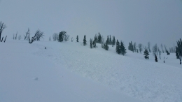
The mountains near Cooke City have 2 feet of new snow equal to 2” of snow water equivalent (SWE) since Friday. Strong westerly winds drifted this snow into slabs 2-4 feet deep that will break naturally and be easy to trigger. These wind slabs are located below cornices along ridgelines, and lower on slopes along cross-loaded terrain and below cliffs (photo). Avoid travel on steep, wind-loaded slopes and minimize time in flatter terrain below. These avalanches could run far and have the power to break trees, similar to recent slides I saw on Thursday (video, photo). Yesterday, a skier triggered an 18” deep, 150’ wide avalanche on a wind loaded slope (photo), and similar or larger slides are likely today.
On non-wind loaded slopes avalanches are easy to trigger within the recent storm snow, and could break deeper and wider on a weak layer of surface hoar buried 3-4 feet deep (photo). Be extra cautious of all steep slopes, and practice conservative route finding and decision making. The safest bet is lower angle slopes sheltered from the wind, and not exposed to steep, wind-loaded terrain above. Avalanche danger is HIGH on wind loaded slopes and CONSIDERABLE on other steep slopes.

In the mountains near West Yellowstone and the southern Madison and Gallatin ranges, strong wind over the past 24 hours drifted recent snow into fresh wind slabs that are possible to trigger. Be cautious of wind loaded slopes along ridgelines, on cross-loaded terrain features, or along the bottoms of cliffs. On non-wind loaded slopes, avalanches are possible to trigger on a layer of surface hoar buried 1-2’ deep (photo, video), or on weak facets near the ground. These weak layers are not present or unstable on every slope. Dig a hole and assess these layers before riding steep slopes. Today, avalanches are possible to trigger and avalanche danger is MODERATE.
The mountains near Bozeman and Big Sky have 5-7” of new snow since Friday. Strong winds drifted this snow into small, fresh slabs that are possible to trigger. Yesterday, skiers in Hyalite, Beehive, and the northern Bridger Range reported small natural and skier triggered wind slabs. Be cautious of wind loaded slopes near ridgelines and at the base of cliffs. Avoid riding above terrain traps like cliffs or dense trees to minimize the consequences of being caught in a slide. On non-wind loaded slopes the snowpack is generally stable (video). Avalanche danger is MODERATE on wind loaded slopes and LOW elsewhere.
If you get out and have any avalanche or snowpack observations to share, drop a line via our website, email (mtavalanche@gmail.com), phone (406-587-6984), or Instagram (#gnfacobs).
Upcoming Avalanche Education and Events
BOZEMAN
Feb. 6th, Sidecountry specific avalanche awareness for family and friends. 6-8 p.m. @ Beall Park
Feb. 7th, Woman’s specific avalanche awareness, 6-7:30 p.m. @ REI in Bozeman
Feb. 7th, Avalanche awareness, 6-7:00 p.m. @ Roskie Hall MSU
Feb. 9 and 10, Companion Rescue Clinic, Info and Register
Feb. 28th, Know Before You Go avalanche awareness, 7:00 p.m. @ Procrastinator Theater, MSU
March 2nd, Avalanche Awareness, 6-7:00 p.m. Bozeman Split Fest
March 7th, Avalanche Awareness, 6-7:30 p.m. @ REI
PHILLIPSBURG
Feb. 8th, Avalanche Awareness, 6:30-8:30 p.m. @ the new Fire Hall
DILLON
Feb. 24th and 25th, Snowmobile intro to avalanches w/ field course. More info: https://msuextension.org/conference/.
WEST YELLOWSTONE
Feb. 10th, Avalanche Awareness, 7-8 p.m. at West Yellowstone Holiday Inn Conference Center
COOKE CITY
Every Friday and Saturday, Current Conditions Update and Avalanche Rescue, Friday 6:30-7:30 p.m. at The Soda Butte Lodge in February. Saturday anytime between 10-2 @ Round Lake.
Here’s a blog post Doug wrote about the uncertainty regarding the Cooke City snowpack right now.