Good Morning. This is Doug Chabot with the Gallatin National Forest Avalanche Advisory issued on Wednesday, February 7th at 7:15 a.m. Today’s advisory is sponsored by Grizzly Outfitters in partnership with the Friends of the Avalanche Center. This advisory does not apply to operating ski areas.
Since yesterday morning 3-4” fell in the mountains around Bozeman, Big Sky, Cooke City and 1-2” outside West Yellowstone. Under cloudy skies, west winds are averaging 25-30 mph with gusts of 55 mph in the north and 15-30 mph in the south. By tomorrow morning expect 2-4” in the mountains around Bozeman and Big Sky, and 4-8” around West Yellowstone and Cooke City. Temperatures will reach the low 20’s this afternoon with strong westerly winds.

Cooke City
Yesterday a large avalanche was triggered by a cornice on east Woody Ridge south of town. The wind-loaded slope broke up to 10’ deep at the ridgeline (photo). The mountains have gotten over 4’ of snow in the last 5 days with wind loading slopes even more (photo). The slide on Woody was large and destructive and it is still possible for similar avalanches to occur. Wind loads are found near ridges, and not just on east-facing slopes from west winds: they will be found on many aspects underneath cornices and along ridges where winds cross-loaded and drifted snow into gullies. On slopes without a wind load it’s possible to trigger a slide within the new snow or on a weak layer buried underneath it. For today, the avalanche danger is rated CONSIDERABLE on wind-loaded terrain and MODERATE elsewhere.
Bridger Range Northern Madison Range Northern Gallatin Range
In the Bridger Range about 2” of snow water equivalent fell north of Bridger Bowl since Sunday night which has settled to 10” of snow depth. Yesterday, Eric and Gabrielle (our intern) rode and skied into the bowl below Naya Nuki and measured the water content and found relatively good stability which is outlined in their video. West winds are gusting into the 50s and wind-loaded slopes are the main avalanche concern. There has been snowfall in the northern mountains every day for the last 8 days (weather log) and today’s winds have drifted this snow and increased the avalanche danger. On non-wind-loaded slopes the stability is good, but with all the steady snowfall avalanches are still possible. For today, the avalanche danger is rated CONSIDERABLE on wind-loaded slopes and MODERATE on all others.

Southern Madison Range Southern Gallatin Range Lionhead area near West Yellowstone
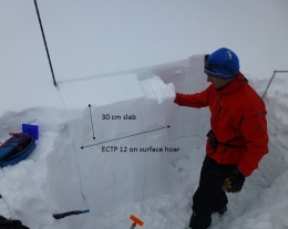
The southern mountains, including the West Yellowstone area, have a couple weak layers that are problematic. The first is a layer of surface hoar buried 1-2’ deep. It is not easy to spot in a snowpit wall, nor is it widespread. The second is sugary facets near the ground that is getting more stubborn to trigger. Both of these layers broke in our stability tests on Sunday when Alex and I skied near Hebgen Lake (video, snowpit), so we decided to adjust our intended descent to a more conservative line. For today, the avalanche danger is MODERATE since avalanches are still possible.
If you get out and have any avalanche or snowpack observations to share, drop a line via our website, email (mtavalanche@gmail.com), phone (406-587-6984), or Instagram (#gnfacobs).
White Heat Tracks Project seeks your input
The aim of the White Heat Project is to generate new and usable knowledge on risk-taking behavior, and on factors behind decision errors in avalanche terrain in particular. The White Heat Tracks project is an extension to the previous "SkiTracks" project, and is a collaboration between a group of researchers at UiT The Arctic University of Norway, in Tromsø; Montana State University, in Bozeman, USA; and Umeå University, in Umeå, Sweden. We are asking people to complete a decision-making survey: (https://montana.qualtrics.com/jfe/form/SV_74aRQuWMj0wbJHv) and if they have time and energy, also submit GPX tracks of their backcountry trips to "tracks@montana.edu
More information can be found here:
http://www.montana.edu/snowscience/tracks.html
And here: http://www.montana.edu/news/17430
Upcoming Avalanche Education and Events
BOZEMAN
TONIGHT! Feb. 7th, Woman’s specific avalanche awareness, 6-7:30 p.m. @ REI in Bozeman
TONIGHT! Feb. 7th, Avalanche awareness, 6-7:00 p.m. @ Roskie Hall MSU
Feb. 9 and 10, Companion Rescue Clinic, Info and Register
Feb. 28th, Know Before You Go avalanche awareness, 7:00 p.m. @ Procrastinator Theater, MSU
March 2nd and 3rd, SheJumps Companion Rescue Clinic, Info and Register HERE
March 2nd, Avalanche Awareness, 6-7:00 p.m. Bozeman Split Fest
March 7th, Avalanche Awareness, 6-7:30 p.m. @ REI
PHILLIPSBURG
TOMORROW! Feb. 8th, Avalanche Awareness, 6:30-8:30 p.m. @ the new Fire Hall
DILLON
Feb. 24th and 25th, Snowmobile intro to avalanches w/ field course. More info: https://msuextension.org/conference/.
WEST YELLOWSTONE
Feb. 10th, Avalanche Awareness, 7-8 p.m. at West Yellowstone Holiday Inn Conference Center
COOKE CITY
Every Friday and Saturday, Current Conditions Update and Avalanche Rescue, Friday 6:30-7:30 p.m. at The Soda Butte Lodge in February. Saturday anytime between 10-2 @ Round Lake.
In Dashboard Talk: Episode 5 Doug and Eric discuss being safe while gathering snow stability data.