Good Morning. This is Eric Knoff with the Gallatin National Forest Avalanche Advisory issued on Thursday, February 8th at 7:15 a.m. Today’s advisory is sponsored by Highline Partners and Montana State Parks. This advisory does not apply to operating ski areas.
AVALANCHE WARNING
The Gallatin National Forest Avalanche Center is issuing a Backcountry Avalanche Warning for the mountains near Cooke City. Heavy snow and strong wind is creating very dangerous avalanche conditions. The avalanche danger is rated HIGH on all slopes. Natural and human triggered avalanches are likely today. Avalanche terrain and avalanche runout zones should be avoided.
Since yesterday morning the mountains around Cooke City picked up close to a foot of new snow. The Bridger Range picked up 6-8” while Hyalite and Big Sky received 2-4”. The mountains around West Yellowstone squeezed out 1-2”. This morning it’s still snowing around Cooke City while the rest of advisory area remains dry. Temps range from the 20’s to low 30’s F and winds are blowing 15-30 mph out the W-SW with ridgetop gusts around Big Sky breaking 40 mph. Today, snow will continue around Cooke City where an additional 4-6” will fall by this evening. The rest of the advisory are could see 1-2” by later today. Snow increases tonight and much of the advisory area will see 4-6” by morning. The exception is the mountains around West Yellowstone which will see 1-3”.

Avalanche Warning
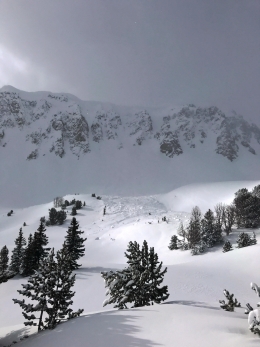
It has snowed eleven out of the past twelve days around Cooke City and winds have been moderate to strong out of the west (weather log). The relentless combo of snow and wind has pushed many slopes past their breaking point. A large and destructive natural avalanche off Woody Ridge on Tuesday is a prime example of what’s possible (photo). A foot of snow overnight and more today will only make conditions more unstable. Until the snowpack gets a breather, the best option will be to avoid avalanche terrain including avalanche runout zones (photo).
Today, natural and human triggered avalanches are likely and the avalanche danger is rated HIGH on all slopes.

Bracket Creek Snotel site in the northern Bridgers has picked up over 3” of snow water equivalent over the past four days. What’s unusual is Bridge Bowl has picked up roughly half that amount. The bottom line is – the sheer volume and weight of the new snow is putting a tremendous amount of stress on the snowpack. Wind loaded slopes will be the most prone to avalanches, but non-wind slopes remain suspect. We know the Bridger Range has a generally strong snowpack (video), but 3” of SWE in four days is enough expose any weakness. I wouldn’t be surprised if large natural avalanches occur, mainly in the northern part of the range. With more snow and wind on the way, the snowpack will remain on edge.
For this reason, the avalanche danger is rated CONSIDERABLE on all slopes.
Hyalite and Big Sky have received enough snow and wind to keep the avalanche danger elevated, mainly on wind loaded slopes. Overnight, winds blew 20-40 mph out of the west-southwest, which likely formed dense slabs in leeward terrain. Warm temps will keep wind slabs stubborn today, but they still can’t be trusted. These conditions also facilitate rapid cornice growth. Watch out for and avoid slopes beneath large cornices and give them a wide distance along the ridgelines.
Today, dangerous avalanche conditions exist on wind loaded slopes which have a CONSIDERABLE avalanche danger. Non-wind loaded slopes have a MODERATE avalanche danger.

The southern mountains haven’t received as much snow as the northern ranges. Carrot Basin Snotel site in the southern Madison Range is showing .4” of SWE over the past three days while Madison Plateau near West Yellowstone is showing .1” of SWE. Although snow amounts are less, buried surface hoar two feet deep and moderate to strong winds out of the west will present a few different problems today.
Watch out for wind loaded slopes near the ridgelines and avoid areas around large cornices. Also keep an eye out for surface hoar buried two feet deep. Yesterday, my partner and I rode in the Taylor Fork and got this layer to propagate consistently in stability tests (video). Doug and Alex also got unstable results on this layer near Hebgen Lake earlier in the week (video).
Wind loaded slopes and buried weak layers make human triggered avalanches possible and the avalanche danger is rate MODERATE.
If you get out and have any avalanche or snowpack observations to share, drop a line via our website, email (mtavalanche@gmail.com), phone (406-587-6984), or Instagram (#gnfacobs).
White Heat Tracks Project seeks your input
The aim of the White Heat Project is to generate new and usable knowledge on risk-taking behavior, and on factors behind decision errors in avalanche terrain in particular. The White Heat Tracks project is an extension to the previous "SkiTracks" project, and is a collaboration between a group of researchers at UiT The Arctic University of Norway, in Tromsø; Montana State University, in Bozeman, USA; and Umeå University, in Umeå, Sweden. We are asking people to complete a decision-making survey: (https://montana.qualtrics.com/jfe/form/SV_74aRQuWMj0wbJHv) and if they have time and energy, also submit GPX tracks of their backcountry trips to "tracks@montana.edu
More information can be found here:
http://www.montana.edu/snowscience/tracks.html
And here: http://www.montana.edu/news/17430
Upcoming Avalanche Education and Events
BOZEMAN
Feb. 9 and 10, Companion Rescue Clinic, Info and Register
Feb. 28th, Know Before You Go avalanche awareness, 7:00 p.m. @ Procrastinator Theater, MSU
March 2nd and 3rd, SheJumps Companion Rescue Clinic, Info and Register HERE
March 2nd, Avalanche Awareness, 6-7:00 p.m. Bozeman Split Fest
March 7th, Avalanche Awareness, 6-7:30 p.m. @ REI
PHILLIPSBURG
TONIGHT! Feb. 8th, Avalanche Awareness, 6:30-8:30 p.m. @ the new Fire Hall
DILLON
Feb. 24th and 25th, Snowmobile intro to avalanches w/ field course. More info: https://msuextension.org/conference/.
WEST YELLOWSTONE
Feb. 10th, Avalanche Awareness, 7-8 p.m. at West Yellowstone Holiday Inn Conference Center
COOKE CITY
Every Friday and Saturday, Current Conditions Update and Avalanche Rescue, Friday 6:30-7:30 p.m. at The Soda Butte Lodge in February. Saturday anytime between 10-2 @ Round Lake.
In Dashboard Talk: Episode 5 Doug and Eric discuss being safe while gathering snow stability data.